
1965 Puget Sound earthquake
 Olympia Seattle | |
| UTC time | 1965-04-29 15:28:45 |
|---|---|
| ISC event | 858143 |
| USGS-ANSS | ComCat |
| Local date | April 29, 1965 |
| Local time | 08:28:45 PDT |
| Magnitude | 6.7 Mw[1] |
| Depth | 59 km (37 mi)[2] |
| Epicenter | 47°24′N 122°18′W / 47.4°N 122.3°W |
| Type | Dip-slip |
| Areas affected | Puget Sound region Washington United States |
| Total damage | $12.5–28 million[2] |
| Max. intensity | MMI VIII (Severe) |
| Peak acceleration | 0.204 g at Olympia |
| Aftershocks | None |
| Casualties | 7 dead |
The 1965 Puget Sound earthquake occurred at 08:28 AM PDT (15:28 UTC) on April 29 within the Puget Sound region of Washington state. It had a magnitude of 6.7 on the moment magnitude scale and a maximum perceived intensity of VIII (Severe) on the Mercalli intensity scale. It caused the deaths of seven people and about $12.5–28 million in damage.[2][3] There were no recorded aftershocks.[4]
Tectonic setting[edit]
The western part of Washington State lies above the Cascadia subduction zone, where the Juan de Fuca Plate is being subducted beneath the North American Plate. The seismicity of this region consists of rare great megathrust earthquakes, like the 1700 Cascadia earthquake and more common earthquakes originating from within the subducting slab. These events relate to normal faulting, associated with the bending of the slab, possibly related to a phase change below about 40 km from basalt/gabbro to eclogite.[5]
Earthquake[edit]
The earthquake had an estimated magnitude of 6.6 Ms, 6.5 mb and 6.7 Mw.[1][2] At 10–20 seconds the duration of strong ground motion was relatively short.[6] The earthquake's focal mechanism indicates that it resulted from normal faulting within the Juan de Fuca slab. There were no recorded aftershocks, similar to observations from the 1949 Olympia and 2001 Nisqually earthquakes and a characteristic of such intraslab events.[5]
Intensity[edit]
The pattern of shaking intensity was somewhat variable, with a large region with an intensity of VII (Very strong) containing localized areas of intensity VIII (Severe).[3] These variations generally relate closely to the underlying geology, with higher intensities recorded where there was either artificial fill or alluvium, although there were some exceptions.[4] The observed pattern of intensities was very similar to those from the 1949 Olympia and 2001 Nisqually earthquakes.[1]
Damage[edit]
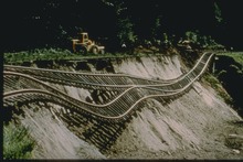
Three people were killed by falling debris in the Duwamish valley floor area of Seattle,[6] and four others died from heart attacks.[7] There was minor damage recorded over a large area, including fallen chimneys and cracked mortar. The two Boeing plants at Renton and Seattle, both built on artificial fill and mudflats, suffered major damage.[4] The State Capitol building in Olympia suffered cracking to the dome and supporting buttresses, leaving it in a condition where a major aftershock could have caused complete collapse.[8] Single-story unreinforced brick buildings performed the worst in the earthquake with wood-framed structures generally performing very well.[3] Major highways had relatively little damage, with some sections of U.S. Route 101 sinking 1 to 2 feet (0.30 to 0.61 m). The Tacoma Narrows Bridge was closed for 30 minutes as a precaution but reopened with only damage to light fixtures and weather seals on cables.[9]
Ground acceleration[edit]
A peak ground acceleration of 0.204g was measured at Olympia.[4]
Aftermath[edit]
The damage and deaths in the 1965 earthquake helped bring about the installation of the Pacific Northwest Seismic Network in 1969.[10]
See also[edit]
References[edit]
- ^ a b c Dewey, J.W.; Hopper, M.G.; Wald, D.J.; Quitoriano V. & Adams E.R. (2002). Intensity Distribution and Isoseismal Maps for the Nisqually, Washington, Earthquake of 28 February 2001 (PDF). Open-File Report. Vol. 02–346. United States Geological Survey. p. 15.
- ^ a b c d National Geophysical Data Center / World Data Service (NGDC/WDS): NCEI/WDS Global Significant Earthquake Database. NOAA National Centers for Environmental Information. "Significant Earthquake Information". doi:10.7289/V5TD9V7K. Retrieved March 22, 2024.
- ^ a b c United States Geological Survey (October 21, 2009). "Puget Sound area, Washington 1965 04 29 15:28:43.7 UTC Magnitude 6.5 Intensity VIII". Historic Earthquakes. Retrieved January 8, 2012.
- ^ a b c d Oakeshott, G.B. (July 1965). "The Seattle Earthquake" (PDF). Mineral Information Service. 18 (7): 140–141. Archived from the original (PDF) on March 12, 2020. Retrieved January 8, 2012.
- ^ a b Wong, I.G. (2005). "Low Potential for Large Intraslab Earthquakes in the Central Cascadia Subduction Zone" (PDF). Bulletin of the Seismological Society of America. 95 (5): 1880–1902. Bibcode:2005BuSSA..95.1880W. doi:10.1785/0120040132. Archived from the original (PDF) on March 2, 2012. Retrieved January 8, 2012.
- ^ a b Mullineaux, D.R.; Bonilla, M.G.; Schlocker, J. (1967). "Relation of building damage to geology in Seattle, Washington during the April 1965 earthquake". Geological Survey Research 1967. United States Geological Survey Professional paper. Vol. 575-D. United States Government Printing Office. pp. 183–191. Retrieved January 8, 2012.
- ^ Cascadia Region Earthquake Workshop (2008). "Cascadia Deep Earthquakes" (PDF). Open File Report 2008-1. Washington Division of Geology and Earth Resources. p. 8. Archived from the original (PDF) on March 2, 2012. Retrieved January 8, 2012.
- ^ David Postman (March 4, 2001). "Is Capitol dome at risk? Huge stone columns knocked out of line". The Seattle Times. Archived from the original on December 9, 2012. Retrieved January 8, 2012.
- ^ "All The Fear A Word Can Make—Earthquake!". Washington Highway News. Vol. 12, no. 4. Washington State Department of Highways. May 1965. p. 14. Retrieved August 17, 2022 – via WSDOT Library Digital Collections.
- ^ United States Geological Survey (July 27, 2011). "ANSS – Advanced National Seismic System Pacific Northwest Region". Retrieved January 8, 2012.
External links[edit]
- The International Seismological Centre has a bibliography and/or authoritative data for this event.