
Al-Rihaniyya
Al-Rihaniyya
Rihaniya, -al[1] | |
|---|---|
| Etymology: "Sweet basil"[2][3] | |
.jpg) 1870s map 1870s map .jpg) 1940s map 1940s map.jpg) modern map modern map .jpg) 1940s with modern overlay map 1940s with modern overlay mapA series of historical maps of the area around Al-Rihaniyya (click the buttons) | |
 Al-Rihaniyya Location within Mandatory Palestine | |
| Coordinates: 32°37′12″N 35°05′13″E / 32.62000°N 35.08694°E | |
| Palestine grid | 158/225 |
| Geopolitical entity | Mandatory Palestine |
| Subdistrict | Haifa |
| Date of depopulation | Not known[1] |
| Population (1945) | |
| • Total | 240[4][5] |
| Current Localities | Ramat HaShofet[2] Ein HaEmek[2] |
Al-Rihaniyya was a Palestinian Arab village in the Haifa Subdistrict. It was depopulated during the 1947–1948 Civil War in Mandatory Palestine on 30 April 1948 as part of the battle of Mishmar HaEmek. It was located 25 km southeast of Haifa and 3 km northwest of Wadi al-Mileh.
History[edit]
In 1882, the PEF's Survey of Western Palestine described Kh. Rihaneh as a ruined modern village, with watch-towers in ruins, and with two springs.[6]
A population list from about 1887 showed that Rihaneh had about 190 inhabitants; all Muslims.[7]
Al-Rihaniyya had an elementary school for boys founded in 1888, but it was closed during the British Mandate period.[2]
British Mandate era[edit]
In the 1922 census of Palestine, conducted by the British Mandate authorities, Al Rehaniyeh had a population of 266 Muslims,[8] increasing in the 1931 census to 293 Muslim, in a total of 55 houses.[9]
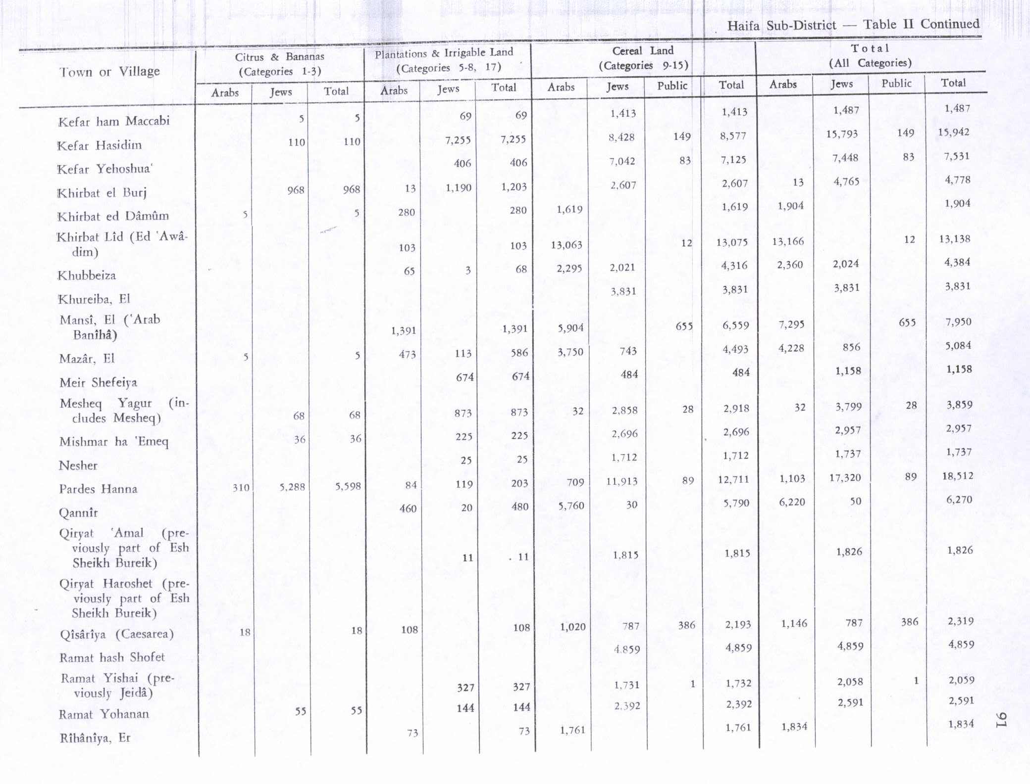
In the 1945 statistics, the village had a population of 240 Muslims,[4] and the village's lands spanned 1,930 dunams.[5] Of this, 1,761 dunums of land were used for cereals; 73 dunums were irrigated or used for orchards,[10] while 46 dunams were built-up (urban) land.[11]
1948, aftermath[edit]
On 5 April 1948, after fighting broke out in the area, the Haganah General Staff instructed the Golani Brigade that they should tell four Arab villages that they were no longer safe, and should evacuate. Among the villages were Abu Shusha, Daliyat al Ruha and Rihaniya.[12] According to Ben Gurion, on 8 or 9 April, a delegation from Mishmar HaEmek had told him that it was "imperative to expel the Arabs [in the area] and to burn the villages".[12]
On 14 April, The New York Times reported that Al-Rihaniyya was occupied, together with Daliyat al Ruha and Al-Butaymat. However Khalidi believes that the actual depopulation only happened two weeks later, during Passover Clearing.[2]
Surviving villagers told Rosemarie Esber that they decided to leave Al-Rihaniyya on 30 April, as "we did not have guns to defend it". They took refugee in Umm az-Zinat, but when the Haganah attacked it (according to the villagers: unprovoked) they fled "with nothing but our clothes on", to Ijzim. They stayed at Ijzim for several months, until it also was attacked by Zionist forces, who "kicked everybody out". Esbers informants ended up in Umm al-Fahm.[13]
Following the war the area was incorporated into the State of Israel, with the village's lands taken over by kibbutz Ramat HaShofet and the moshav of Ein HaEmek.[2]
In 1992 the village site was described: "The rubble of the houses lies in piles that are covered with dirt, bushes, and thorns. The village cemetery (now covered with cactuses) and a well are visible at the bottom of a hill north of the site. Large sections of the adjacent land are used for agriculture; to the south there is an avocado orchard."[14]
References[edit]
- ^ a b Morris, 2004, p. xviii, village #163. Gives both date and cause of depopulation as "Not known".
- ^ a b c d e f Khalidi, 1992, p. 185
- ^ Palmer, 1881, p. 149
- ^ a b Department of Statistics, 1945, p. 14
- ^ a b Government of Palestine, Department of Statistics. Village Statistics, April, 1945. Quoted in Hadawi, 1970, p. 49
- ^ Conder and Kitchener, 1882, SWP II, p. 62
- ^ Schumacher, 1888, p. 179
- ^ Barron, 1923, Table XI, Sub-district of Haifa, p. 34
- ^ Mills, 1932, p. 95
- ^ Government of Palestine, Department of Statistics. Village Statistics, April, 1945. Quoted in Hadawi, 1970, p. 91
- ^ Government of Palestine, Department of Statistics. Village Statistics, April, 1945. Quoted in Hadawi, 1970, p. 141
- ^ a b Morris, 2004, p. 241
- ^ Esber, 2008 , p. 261
- ^ Khalidi, 1992, p. 186
Bibliography[edit]
- Barron, J. B., ed. (1923). Palestine: Report and General Abstracts of the Census of 1922. Government of Palestine.
- Conder, C.R.; Kitchener, H.H. (1882). The Survey of Western Palestine: Memoirs of the Topography, Orography, Hydrography, and Archaeology. Vol. 2. London: Committee of the Palestine Exploration Fund.
- Department of Statistics (1945). Village Statistics, April, 1945. Government of Palestine.
- Esber, R. (2008). Under the Cover of War, The Zionist Expulsions of the Palestinians. Arabicus Books & Media. ISBN 978-0981513171.
- Hadawi, S. (1970). Village Statistics of 1945: A Classification of Land and Area ownership in Palestine. Palestine Liberation Organization Research Center. Archived from the original on 2018-12-08. Retrieved 2009-08-18.
- Khalidi, W. (1992). All That Remains: The Palestinian Villages Occupied and Depopulated by Israel in 1948. Washington D.C.: Institute for Palestine Studies. ISBN 0-88728-224-5.
- Mills, E., ed. (1932). Census of Palestine 1931. Population of Villages, Towns and Administrative Areas. Jerusalem: Government of Palestine.
- Morris, B. (2004). The Birth of the Palestinian Refugee Problem Revisited. Cambridge University Press. ISBN 978-0-521-00967-6.
- Palmer, E.H. (1881). The Survey of Western Palestine: Arabic and English Name Lists Collected During the Survey by Lieutenants Conder and Kitchener, R. E. Transliterated and Explained by E.H. Palmer. Committee of the Palestine Exploration Fund.
- Schumacher, G. (1888). "Population list of the Liwa of Akka". Quarterly Statement - Palestine Exploration Fund. 20: 169–191.
External links[edit]
- Welcome To al-Rihaniyya
- al-Rihaniyya, Zochrot
- Survey of Western Palestine, Map 8: IAA, Wikimedia commons
