
Amur-Nyzhniodniprovskyi District
Amur-Nyzhniodniprovskyi District
Амур-Нижньодніпровський район | |
|---|---|
 Coat of arms | |
| Coordinates: 48°31′16″N 34°58′42″E / 48.52111°N 34.97833°E | |
| Country | |
| Municipality | Dnipro Municipality |
| Established | 1918[1] |
| Area | |
| • Total | 71.626 km2 (27.655 sq mi) |
| Population | |
| • Total | 160,123 |
| • Density | 2,200/km2 (5,800/sq mi) |
| Time zone | UTC+2 (EET) |
| • Summer (DST) | UTC+3 (EEST) |
| Postal code | 70403 |
| Area code | +380 562 |
| KOATUU | 1210136300[2] |
| Website | andrada |
|

|
Amur-Nyzhniodniprovskyi District (Ukrainian: Амур-Нижньодніпровський район; sometimes abbreviated as "AND") is an urban district[3] of the city of Dnipro, in southern Ukraine.[4][5] It is located on the city's north and on the left-bank of Dnieper River along with the city's Industrialnyi and Samarskyi districts.
Its name is derived from a small settlement of Amur and the Nyzhniodniprovsk railway station. The first village located on what is now the Amur-Nyzhniodniprovskyi District was founded in the late 16th century, making the area one of the oldest inhabited parts of Dnipro.[1]
History[edit]
According to historical findings on the current territory of the Amur-Nyzhniodniprovskyi District there was a village called Kamianka that was founded in 1596.[1] Kamianka is considered to be one of the oldest settlements in Left-bank Ukraine.[1] In 1757 the village Berezanivka was founded by the Zaporozhian Cossack Berezan.[1] The territory contained the settlement of Manuylivka (the Ukrainian SSR changed the name to Vorontsovka in 1922) which was named after the Cossack settler Manuil.[1]
Until 1786 all three villages belonged to belonged to the Samara province (palanka) of Zaporizhian Sich.[1] After the liquidation of Zaporizhian Sich by the Russian government of Catherine the Great in 1775, the region was admitted into the newly formed Novomoskovsk county of Yekaterinoslav Governorate.[1] The territory on the left bank of Dnieper across Yekaterinoslav at interfluvial region between Dnieper and Samara was known locally as Zadniprovia (Trans-Dnieper region).
The village of Amur emerged in 1875 and contained various factories.[1] To the east of Amur there was a village Baraf which was merged with Amur to form an industrial small city named Amur-Nyzhniodniprovskyi (Nyzhniodniprovskyi meaning "Lower Dnieper").[1] After a railway was laid in the area in 1895/1897 the area became heavy industrial.[1] In September 1917 all settlements of Zadniprovia were organized into a district of Zadniprovskyi Raion.[1] On 25 January 1918 the district was renamed into Amur-Nyzhniodniprovsk.[1]
In World War II the area saw heavy fighting during the June 1941 phase of Operation Barbarossa.[1]
In 1969 the district was split in half and at its eastern and northern portions was created the Industrialnyi District.[1] From the late 1970s until the mid 1980s the district was greatly expanded.[1]
In the night of 22-23 February 2024 a Russian attack with a Shahed drone (as part of the Russian missile attacks on Dnipro of the Russian invasion of Ukraine) hit a high-rise residential building in the district, killing two people.[6][7]
Population[edit]
Language[edit]
Distribution of the population by native language according to the 2001 census:[8]
| Language | Number | Percentage |
|---|---|---|
| Ukrainian | 84 283 | 52.64% |
| Russian | 74 570 | 46.57% |
| Other[a] | 1 270 | 0.79% |
| Total | 160 123 | 100.00% |
| a Those who did not indicate their native language or indicated a language that was native to less than 1% of the local population. |
Neighborhoods[edit]
- Amur
- Nyzhniodniprovsk
- Manuilivka
- Sakhalin
- Sultanivka
- Sonyachny
- Kalynovskyi
- Borzhom
- Kamianka
- Lomivka
- Livoberezhnyi
- Berezanivka
Gallery[edit]
-
 A panoramic view of the Amur-Nyzhniodniprovskyi District
 -
![The Amur-Nyzhniodniprovskyi District's Slobozhanskyi Avenue [uk; ru]](//upload.wikimedia.org/wikipedia/commons/thumb/a/ac/%D0%9C%D0%B0%D0%B3%D0%B0%D0%B7%D0%B8%D0%BD_%D0%9E%D0%BA%D0%B5%D0%B0%D0%BD.jpg/120px-%D0%9C%D0%B0%D0%B3%D0%B0%D0%B7%D0%B8%D0%BD_%D0%9E%D0%BA%D0%B5%D0%B0%D0%BD.jpg) The Amur-Nyzhniodniprovskyi District's Slobozhanskyi Avenue
The Amur-Nyzhniodniprovskyi District's Slobozhanskyi Avenue -
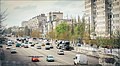 The Amur-Nyzhniodniprovskyi District's Slobozhanskyi Avenue
 -
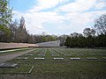 Soviet military cemetery
.jpg)
![The Amur-Nyzhniodniprovskyi District's Slobozhanskyi Avenue [uk; ru]](https://www.qudswiki.org/?query=File:%D0%9C%D0%B0%D0%B3%D0%B0%D0%B7%D0%B8%D0%BD_%D0%9E%D0%BA%D0%B5%D0%B0%D0%BD.jpg)


References[edit]
- ^ a b c d e f g h i j k l m n o p "Amur-Nyzhnodniprovskyi Raion". Official Internet-portal (in Ukrainian). Dnipro City Council. Archived from the original on 14 April 2019. Retrieved 17 August 2020.
- ^ "Amur-Nyzhnodniprovskyi District Council". Informational portal of the self-government in Ukraine (in Ukrainian). Rada.info. Retrieved 5 February 2015.
- ^ (in Ukrainian) In Dnipro 655 officials and employees of the city hall were fired in 5 minutes, Ukrayinska Pravda (10 February 2021)
- ^ "Amur-Nyzhnodniprovskyi Raion, Dnipropetrovsk Oblast, City of Dnipropetrovsk". Regions of Ukraine and their Structure (in Ukrainian). Verkhovna Rada of Ukraine. Archived from the original on 4 March 2016. Retrieved 2 February 2015.
- ^ (in Ukrainian) The Dubynskys' group played 49 million to patch holes after repairing heating networks, Ukrayinska Pravda (31 January 2020)
- ^ "Man's body retrieved from rubble of house in Dnipro hit by drone – photo". Ukrainska Pravda. 23 February 2023. Retrieved 23 February 2023.
"Death toll from Russian attack on Dnipro rises to two, woman's body found". Ukrainska Pravda. 23 February 2023. Retrieved 23 February 2023. - ^ "18 apartments of the house, where the Russian hit « Shahed», will be temporarily relocated: the city compensates the owners for the rent". Informator (in Ukrainian). 23 February 2024. Retrieved 23 February 2024.
Stas Rudenko (21 June 2023). "Smooth remains: 36 streets have been renamed in Dnieper, one of them - again". Informator (in Ukrainian). Retrieved 23 February 2024. - ^ "Рідні мови в об'єднаних територіальних громадах України" (in Ukrainian).
External links[edit]
| Districts | |||||
|---|---|---|---|---|---|
| Neighborhoods |
| ||||
| |||||