File:1947 ROC claim line in Ladakh.jpg

Page contents not supported in other languages.
This is a file from the Wikimedia Commons
From Wikipedia, the free encyclopedia

Original file(644 × 619 pixels, file size: 172 KB, MIME type: image/jpeg)

Summary

Description
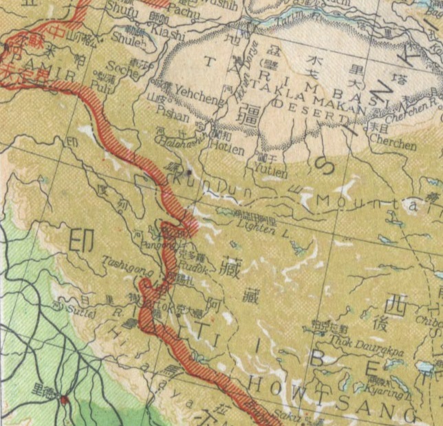
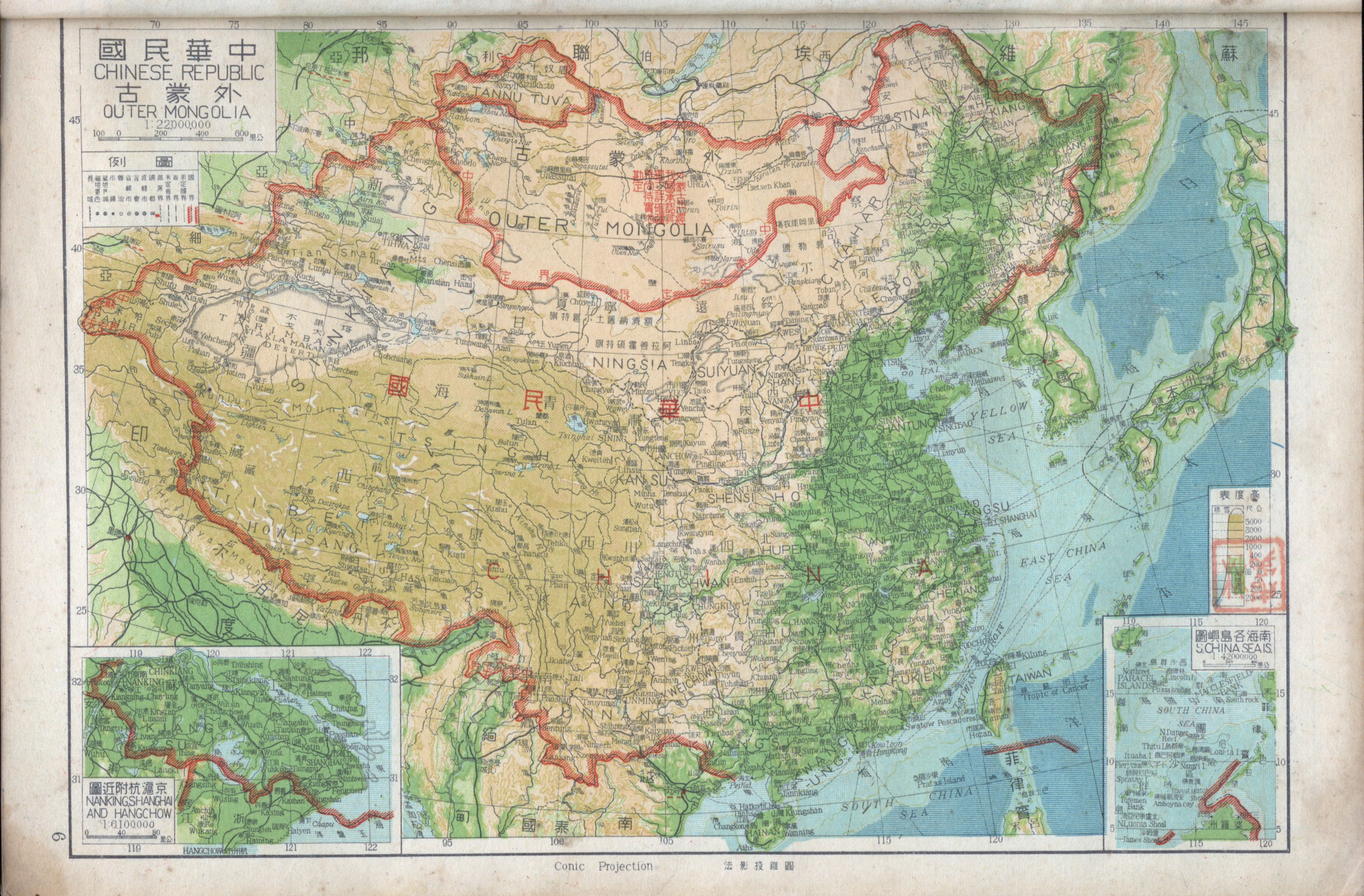
English: This extract from a 1947 map of the w:Republic of China (1912–1949) shows the border claimed against the Ladakh region of India. Though the map is of low resolution, it is possible to conclude that: See Karackattu, Joe Thomas (2020). "The Corrosive Compromise of the Sino-Indian Border Management Framework: From Doklam to Galwan". Asian Affairs 51 (3): 590–604. DOI:10.1080/03068374.2020.1804726. ISSN 0306-8374.
Date
Source https://www.nansha.org.cn/maps/3/1947_ROC_Map.jpg
Author Republic of China
Other versions
image extraction process
This file has been extracted from another file
: 1947 Zhonghua Minguo Quantu.png
original file

Licensing

Public domain
This image is now in the public domain in China because its term of copyright has expired.

According to copyright laws of the People's Republic of China (with legal jurisdiction in the mainland only, excluding Hong Kong and Macao), amended November 11, 2020, Works of legal persons or organizations without legal personality, or service works, or audiovisual works, enter the public domain 50 years after they were first published, or if unpublished 50 years from creation. For photography works of natural persons whose copyright protection period expires before June 1, 2021 belong to the public domain. All other works of natural persons enter the public domain 50 years after the death of the creator.
According to copyright laws of Republic of China (currently with jurisdiction in Taiwan, Penghu, Kinmen, Matsu, etc.), all photographs and cinematographic works, and all works whose copyright holder is a juristic person, enter the public domain 50 years after they were first published, or if unpublished 50 years from creation, and all other applicable works enter the public domain 50 years after the death of the creator.

Important note: Works of foreign (non-U.S.) origin must be out of copyright or freely licensed in both their home country and the United States in order to be accepted on Commons. Works of Chinese origin that have entered the public domain in the U.S. due to certain circumstances (such as publication in noncompliance with U.S. copyright formalities) may have had their U.S. copyright restored under the Uruguay Round Agreements Act (URAA) if the work was under copyright in its country of origin on the date that the URAA took effect in that country. (For the People's Republic of China, the URAA took effect on January 1, 1996. For the Republic of China (ROC), the URAA took effect on January 1, 2002.[1])
To uploader: Please provide where the image was first published and who created it or held its copyright.

You must also include a United States public domain tag to indicate why this work is in the public domain in the United States. Note that this work might not be in the public domain in countries that do not apply the rule of the shorter term and have copyright terms longer than life of the author plus 50 years. In particular, Mexico is 100 years, Jamaica is 95 years, Colombia is 80 years, Guatemala and Samoa are 75 years, Switzerland and the United States are 70 years, and Venezuela is 60 years.


čeština  Deutsch  English  português  română  slovenščina  Tagalog  Tiếng Việt  македонски  русский  മലയാളം  ไทย  한국어  日本語  简体中文‎  繁體中文  +/−


Captions

1947 Republic of China claim line in Ladakh

image/jpeg

9fe49bcc0daa16915a382e64ca66b8a5f42b8cf3

176,621 byte

619 pixel

644 pixel

File history

Click on a date/time to view the file as it appeared at that time.

Date/TimeThumbnailDimensionsUserComment
current16:54, 31 January 2021Thumbnail for version as of 16:54, 31 January 2021644 × 619 (172 KB)Kautilya3Uploaded a work by Republic of China from https://www.nansha.org.cn/maps/3/1947_ROC_Map.jpg with UploadWizard

Global file usage

Metadata