
File:Argentina Misiones location map.svg

Size of this PNG preview of this SVG file: 499 × 600 pixels. Other resolutions: 200 × 240 pixels | 399 × 480 pixels | 639 × 768 pixels | 852 × 1,024 pixels | 1,704 × 2,048 pixels | 520 × 625 pixels.
Original file (SVG file, nominally 520 × 625 pixels, file size: 233 KB)
| This is a file from the Wikimedia Commons. Information from its description page there is shown below. Commons is a freely licensed media file repository. You can help. |
Karai Neêry Duarte
Summary
| Description |
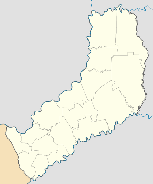
Deutsch: Positionskarte von Misiones (Argentinien) English: Location map of Misiones province (Argentina) Español: Mapa de localización de la Provincia de Misiones.
Equirectangular projection, N/S stretching 112 %. Geographic limits of the map:
|
| Date | (UTC) |
| Source |
This file was derived from: |
| Author |
|
| Other versions |
|

Licensing
This file is licensed under the Creative Commons Attribution-Share Alike 3.0 Unported license.
- You are free:
- to share – to copy, distribute and transmit the work
- to remix – to adapt the work
- Under the following conditions:
- attribution – You must give appropriate credit, provide a link to the license, and indicate if changes were made. You may do so in any reasonable manner, but not in any way that suggests the licensor endorses you or your use.
- share alike – If you remix, transform, or build upon the material, you must distribute your contributions under the same or compatible license as the original.
Original upload log
This image is a derivative work of the following images:
- File:Argentina_location_map.svg licensed with Cc-by-sa-3.0, GFDL
- File:Map_of_Misiones_Province.svg licensed with Cc-by-sa-3.0,2.5,2.0,1.0, GFDL
Uploaded with derivativeFX
File history
Click on a date/time to view the file as it appeared at that time.
| Date/Time | Thumbnail | Dimensions | User | Comment | |
|---|---|---|---|---|---|
| current | 22:19, 28 November 2022 | | 520 × 625 (233 KB) | GrandEscogriffe | more correct north-south stretching |
| 17:06, 7 November 2022 |  | 520 × 650 (237 KB) | Milenioscuro | Reverted to version as of 19:21, 3 May 2018 (UTC) usese los estilos predefinidos para el mapa | |
| 12:38, 7 November 2022 |  | 800 × 600 (367 KB) | CarlosBrys | Pozo Azul y Bernardo de Irigoyen redefinieron sus limites. Se suma Fracrán a los municipios | |
| 19:21, 3 May 2018 |  | 520 × 650 (237 KB) | Milenioscuro | actualizo | |
| 19:08, 3 May 2018 |  | 520 × 650 (232 KB) | Milenioscuro | Reverted to version as of 08:53, 10 September 2017 (UTC) | |
| 12:59, 3 May 2018 |  | 800 × 882 (540 KB) | CarlosBrys | Con la creación del municipio de Pozo Azul se modificaron los departamentos de San Pedro, Eldorado y General Manuel Belgrano | |
| 08:53, 10 September 2017 |  | 520 × 650 (232 KB) | Milenioscuro | capas | |
| 22:58, 9 July 2013 |  | 520 × 650 (370 KB) | Milenioscuro | == {{int:filedesc}} == {{Information |Description={{de|Positionskarte von Salta (Argentinien)}}{{en|Location map of Salta province (Argentina)}}{{es|1=Mapa de localización de la Provincia de Salta.}} Equirectangul... |
File usage
The following pages on the English Wikipedia use this file (pages on other projects are not listed):
- Alba Posse
- Apóstoles
- Aristóbulo del Valle, Misiones
- Arroyo del Medio, Misiones
- Azara, Misiones
- Bernardo de Irigoyen, Misiones
- Campo Grande, Misiones
- Campo Ramón
- Campo Viera
- Capioví
- Caraguatay, Misiones
- Caá Yarí
- Cerro Azul, Misiones
- Cerro Corá, Misiones
- Colonia Alberdi
- Colonia Aurora
- Colonia Delicia
- Colonia Polana
- Colonia Victoria
- Comandante Andresito
- Concepción de la Sierra
- Corpus, Misiones
- Dos Arroyos
- Dos Hermanas, Argentina
- Dos de Mayo, Misiones
- El Alcázar, Misiones
- El Soberbio
- Eldorado, Misiones
- Fachinal, Misiones
- Florentino Ameghino, Misiones
- Garuhapé
- Garuhapé-Mi
- Isla de San Martín (Argentina)
- Itacaruaré
- Leandro N. Alem, Misiones
- Loreto, Misiones
- Los Helechos
- Mojón Grande
- Montecarlo, Misiones
- Mártires, Misiones
- Nueve de Julio, Misiones
- Oberá
- Olegario Víctor Andrade, Misiones
- Panambí
- Posadas, Misiones
- Profundidad, Misiones
- Puerto Esperanza, Misiones
- Puerto Iguazú
- Puerto Leoni
- Puerto Libertad
- Puerto Piray
- Puerto Rico, Argentina
- Ruiz de Montoya
- San Antonio, Misiones
- San Ignacio, Argentina
- San Javier, Misiones
- San José, Misiones
- San Martín, Misiones
- San Pedro, Misiones
- San Vicente, Misiones
- Santa Ana, Misiones
- Santa María, Misiones
- Santiago de Liniers, Misiones
- Santo Pipó
- Tres Capones
- Veinticinco de Mayo, Misiones
- Villa Salto Encantado
- Module:Location map/data/Argentina Misiones Province
- Module:Location map/data/Argentina Misiones Province/doc
Global file usage
The following other wikis use this file:
- Usage on de.wikipedia.org
- Usage on eo.wikipedia.org
- Usage on es.wikipedia.org
- Posadas
- Oberá
- Puerto Iguazú
- Bernardo de Irigoyen (Misiones)
- Alba Posse
- Aeropuerto Internacional de Puerto Iguazú
- Jardín América (Misiones)
- Puerto Esperanza (Argentina)
- Garuhapé
- 25 de Mayo (Misiones)
- 9 de Julio (Misiones)
- Almafuerte (Misiones)
- Aristóbulo del Valle (Misiones)
- Arroyo del Medio (Misiones)
- Azara (Argentina)
- Colonia Aurora
- Dos de Mayo (Misiones)
- Campo Grande (Misiones)
- Eldorado (Misiones)
- Puerto Libertad (Misiones)
- Puerto Rico (Argentina)
- Leandro N. Alem (Misiones)
- San Javier (Misiones)
- Concepción de la Sierra
- Montecarlo (Misiones)
- San Ignacio (Misiones)
- Santa Ana (Misiones)
- El Soberbio
- San Pedro (Misiones)
- Garupá
- Fachinal (Misiones)
- San José (Misiones)
- Tres Capones
- Bonpland (Misiones)
- Candelaria (Misiones)
- Cerro Corá (Misiones)
- Loreto (Misiones)
- Mártires (Misiones)
View more global usage of this file.