
File:Bar'an temple 1986-1.jpg

Size of this preview: 800 × 490 pixels. Other resolutions: 320 × 196 pixels | 640 × 392 pixels | 1,024 × 627 pixels | 1,280 × 783 pixels | 3,162 × 1,935 pixels.
Original file (3,162 × 1,935 pixels, file size: 1.86 MB, MIME type: image/jpeg)
| This is a file from the Wikimedia Commons. Information from its description page there is shown below. Commons is a freely licensed media file repository. You can help. |
Summary
| Description |
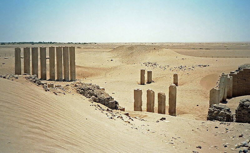
English: Ruins with columns, of Mahram Bilqis or Awwam Temple in 1986 near Ma'rib, Yemen
Français : Ruines du Mahram Bilqis ou temple d'Awam en 1986 près de Marib, Yémen العربية: معبد برآن بالقرب من أوام في عام 1986م |
| Date | |
| Source | Own work |
| Author | Bernard Gagnon |
| Camera location | | View this and other nearby images on: OpenStreetMap |
|---|
Licensing
I, the copyright holder of this work, hereby publish it under the following licenses:

|
Permission is granted to copy, distribute and/or modify this document under the terms of the GNU Free Documentation License, Version 1.2 or any later version published by the Free Software Foundation; with no Invariant Sections, no Front-Cover Texts, and no Back-Cover Texts. A copy of the license is included in the section entitled GNU Free Documentation License. |
This file is licensed under the Creative Commons Attribution-Share Alike 3.0 Unported, 2.5 Generic, 2.0 Generic and 1.0 Generic license.
- You are free:
- to share – to copy, distribute and transmit the work
- to remix – to adapt the work
- Under the following conditions:
- attribution – You must give appropriate credit, provide a link to the license, and indicate if changes were made. You may do so in any reasonable manner, but not in any way that suggests the licensor endorses you or your use.
- share alike – If you remix, transform, or build upon the material, you must distribute your contributions under the same or compatible license as the original.
You may select the license of your choice.
File history
Click on a date/time to view the file as it appeared at that time.
| Date/Time | Thumbnail | Dimensions | User | Comment | |
|---|---|---|---|---|---|
| current | 18:30, 10 February 2012 | | 3,162 × 1,935 (1.86 MB) | Bgag | better version |
| 00:34, 4 July 2010 |  | 3,158 × 2,071 (1.41 MB) | Bgag | tilt corrected | |
| 19:52, 3 July 2010 |  | 3,335 × 2,096 (2.04 MB) | H005 | Denoised | |
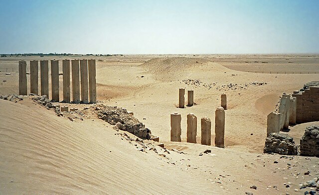
| 18:02, 1 January 2009 |  | 3,335 × 2,096 (2.92 MB) | Bgag | {{Information |Description={{en|1=Bar'an temple ruins in 1986 near Ma'rib, Yemen}} {{fr|1=Ruines du temple Bar'an en 1986 près de Marib, Yémen}} |Source=travail personnel (own work) |Author=Bernard Gagnon |Date=1986-08-18 |Permission= |oth |
File usage
The following pages on the English Wikipedia use this file (pages on other projects are not listed):
Global file usage
The following other wikis use this file:
- Usage on ar.wikipedia.org
- Usage on arz.wikipedia.org
- Usage on ca.wikipedia.org
- Usage on de.wikipedia.org
- Usage on es.wikipedia.org
- Usage on fi.wikipedia.org
- Usage on fr.wikipedia.org
- Usage on he.wikipedia.org
- Usage on it.wikipedia.org
- Usage on ja.wikipedia.org
- Usage on lt.wikipedia.org
- Usage on mt.wikipedia.org
- Usage on oc.wikipedia.org
- Usage on pt.wikipedia.org
- Usage on ru.wikipedia.org
- Usage on www.wikidata.org