
File:Detailed Afroasiatic map.svg

Size of this PNG preview of this SVG file: 800 × 503 pixels. Other resolutions: 320 × 201 pixels | 640 × 402 pixels | 1,024 × 644 pixels | 1,280 × 805 pixels | 2,560 × 1,609 pixels | 1,750 × 1,100 pixels.
Original file (SVG file, nominally 1,750 × 1,100 pixels, file size: 471 KB)
| This is a file from the Wikimedia Commons. Information from its description page there is shown below. Commons is a freely licensed media file repository. You can help. |
Summary
| Description |
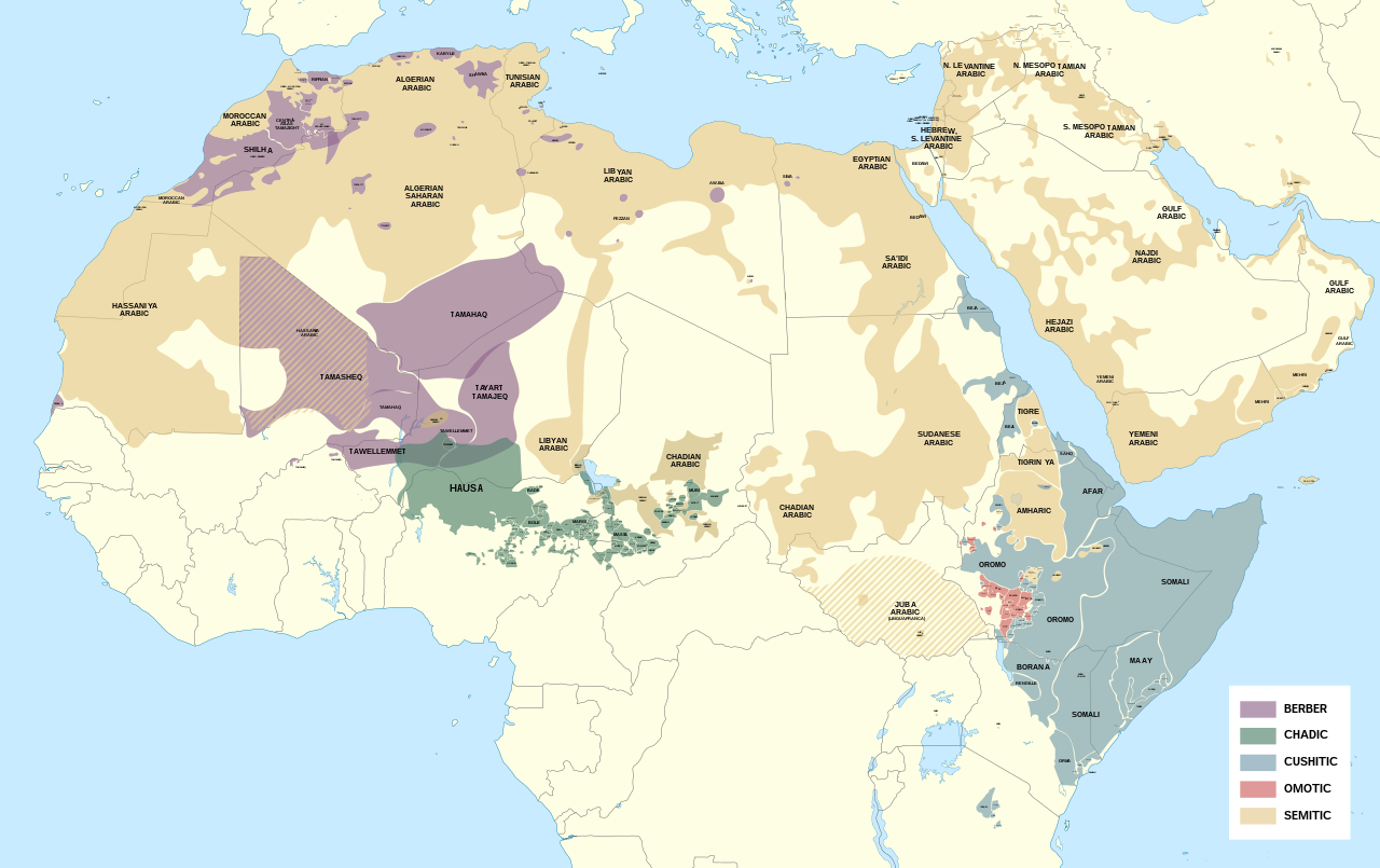
English: Detailed map of Afroasiatic languages in Africa and the Middle East.
This file was derived from: Africa map blank.svg Sources (Wikipedia): External sources:
|
| Date | |
| Source | Own work |
| Author | Noahedits |
![[1]](https://i.pinimg.com/originals/62/b9/94/62b994c3798bc258992de42c46e186fd.png)
![[2]](http://languages.y-bai.com/img/language_map/irq.png)
![[3]](https://i.pinimg.com/564x/8f/52/24/8f522431ee622097dc2550d9ff80480c.jpg)
![[4]](https://i.pinimg.com/originals/d7/88/71/d7887182da05cf42771989eb93960e99.png)
![[5]](https://www.ethnologue.com/sites/default/files/styles/original/public/maps/20/KE_rgb.png?itok=yGwj_XnA)
![[7]](https://www.ethnologue.com/17/sites/default/files/styles/original/public/maps/17/NG_01_rgb/index.png?itok=n1EYvDsI)
![[8]](https://www.ethnologue.com/18/sites/default/files/styles/original/public/maps/18/NG_07_rgb.png?itok=a23BiwQy)
![[9]](https://www.researchgate.net/profile/Adeiza_Isiaka/publication/317208410/figure/fig1/AS:536272059416576@1504868630079/An-index-map-for-some-Nigerian-languages-Ebira-302-is-mainly-spoken-around.png)
![[10]](https://www.researchgate.net/profile/Scott_Maceachern/publication/236160990/figure/fig2/AS:299342981287937@1448380336585/Languages-of-northern-Cameroon-Map-is-the-property-of-SIL-International-and-was-accessed.png)
![[11]](https://asmarttranslatorsreunion.files.wordpress.com/2015/11/om_rgb.png?w=584&h=889)
![[12]](https://1.bp.blogspot.com/-BeNgqhpZtGo/U3LO9MGkfOI/AAAAAAAAIqw/C4np8aWpWdQ/s1600/YE_rgb.png)
![[14]](https://i.pinimg.com/originals/89/42/66/894266f083206db69405d21bc93811a5.png)
![[16]](https://static.cambridge.org/binary/version/id/urn:cambridge.org:id:binary:20190522054803538-0373:9781108283991:41798map10_1.png?pub-status=live)
Licensing
I, the copyright holder of this work, hereby publish it under the following license:
This file is licensed under the Creative Commons Attribution-Share Alike 4.0 International license.
- You are free:
- to share – to copy, distribute and transmit the work
- to remix – to adapt the work
- Under the following conditions:
- attribution – You must give appropriate credit, provide a link to the license, and indicate if changes were made. You may do so in any reasonable manner, but not in any way that suggests the licensor endorses you or your use.
- share alike – If you remix, transform, or build upon the material, you must distribute your contributions under the same or compatible license as the original.
File history
Click on a date/time to view the file as it appeared at that time.
| Date/Time | Thumbnail | Dimensions | User | Comment | |
|---|---|---|---|---|---|
| current | 17:35, 13 May 2022 | | 1,750 × 1,100 (471 KB) | Noahedits | Removing Somaliland (not recognized by the international community) |
| 00:54, 19 October 2021 |  | 1,750 × 1,100 (549 KB) | Gebagebo | Added Somaliland | |
| 19:19, 16 May 2020 |  | 1,750 × 1,100 (471 KB) | Noahedits | Fixed error in Lake Victoria, cleaned up stray lines | |
| 17:33, 23 April 2020 |  | 512 × 322 (484 KB) | Noahedits | Adjusted location of Borana and Burji | |
| 21:04, 1 April 2020 |  | 512 × 322 (447 KB) | Noahedits | Detail in central Arabian peninsula | |
| 22:02, 7 February 2020 |  | 512 × 325 (491 KB) | Noahedits | Cleaned up northern Iraq/Syira, fixed misidentification of Beja | |
| 06:06, 7 February 2020 |  | 512 × 325 (480 KB) | Noahedits | Title, legend, slight clean up | |
| 05:41, 7 February 2020 |  | 512 × 325 (479 KB) | Noahedits | User created page with UploadWizard |
File usage
The following pages on the English Wikipedia use this file (pages on other projects are not listed):
Global file usage
The following other wikis use this file:
- Usage on ar.wikipedia.org
- Usage on el.wikipedia.org
- Usage on es.wikipedia.org
- Usage on fa.wikipedia.org
- Usage on fy.wikipedia.org
- Usage on gl.wikipedia.org
- Usage on he.wikipedia.org
- Usage on ie.wikipedia.org
- Usage on it.wikipedia.org
- Usage on ja.wikipedia.org
- Usage on lij.wikipedia.org
- Usage on mzn.wikipedia.org
- Usage on ne.wikipedia.org
- Usage on sat.wikipedia.org
- Usage on simple.wikipedia.org
- Usage on si.wikipedia.org
- Usage on sr.wikipedia.org
- Usage on sv.wikipedia.org
- Usage on tr.wikipedia.org