
File:Europe under Nazi domination.png

Size of this preview: 654 × 600 pixels. Other resolutions: 262 × 240 pixels | 523 × 480 pixels | 837 × 768 pixels | 1,088 × 998 pixels.
Original file (1,088 × 998 pixels, file size: 187 KB, MIME type: image/png)
| This is a file from the Wikimedia Commons. Information from its description page there is shown below. Commons is a freely licensed media file repository. You can help. |

|
File:World War II in Europe, 1942.svg is a vector version of this file. It should be used in place of this PNG file.
File:Europe under Nazi domination.png → File:World War II in Europe, 1942.svg
For more information, see Help:SVG. |
 |
Summary
| Description |
Русский: Европа в разгаре военных завоеваний Оси Второй мировой войны в 1941–1942
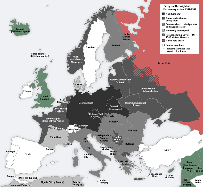
English: Europe at the height of the WWII Axis military conquests in 1941–1942.
中文:1941至42年二戰期間,軸心國的軍事佔領達至高峰時的歐洲。 |
| Date | |
| Source | Own work |
| Author | Morgan Hauser, derived from File:Second world war europe 1943-1945 map en.png and File:Second world war europe 1941-1942 map en.png by users Jarry1250 and ArmadniGeneral, respectively. |
| Other versions |
[]
|


Licensing
I, the copyright holder of this work, hereby publish it under the following license:
This file is licensed under the Creative Commons Attribution-Share Alike 3.0 Unported license.
- You are free:
- to share – to copy, distribute and transmit the work
- to remix – to adapt the work
- Under the following conditions:
- attribution – You must give appropriate credit, provide a link to the license, and indicate if changes were made. You may do so in any reasonable manner, but not in any way that suggests the licensor endorses you or your use.
- share alike – If you remix, transform, or build upon the material, you must distribute your contributions under the same or compatible license as the original.
File history
Click on a date/time to view the file as it appeared at that time.
| Date/Time | Thumbnail | Dimensions | User | Comment | |
|---|---|---|---|---|---|
| current | 11:43, 23 January 2015 | | 1,088 × 998 (187 KB) | DIREKTOR | Fixed error in Thrace: Germany occupied a strip of Greek territory at the border with Turkey. |
| 10:54, 22 January 2015 |  | 1,088 × 998 (187 KB) | DIREKTOR | Fixed error at Crete. | |
| 09:30, 22 January 2015 |  | 1,088 × 998 (187 KB) | DIREKTOR | Added brackets "(Under Military Admin.)", and capitalized "Z" in "zone". | |
| 00:10, 22 January 2015 |  | 1,088 × 998 (187 KB) | DIREKTOR | Restored Vichy France label. | |
| 21:46, 21 January 2015 |  | 1,088 × 998 (187 KB) | DIREKTOR | Small label fix. | |
| 21:42, 21 January 2015 |  | 1,088 × 998 (187 KB) | DIREKTOR | "Reichskommissariat Niederlande" -> "RK Niederlande" | |
| 21:41, 21 January 2015 |  | 1,088 × 998 (188 KB) | DIREKTOR | Further fixes and modifications: the Netherlands were not a Nazi co-belligerent: replaced "Netherlands" with "Reichskommissariat Niederlande"; Denmark was not formally occupied by 1941-42; introduced uniform labels for territories under military occupa... | |
| 16:30, 11 October 2014 |  | 1,088 × 998 (187 KB) | DIREKTOR | "Norway" -> "Reichskommissariat Norwegen" | |
| 15:14, 11 October 2014 |  | 1,088 × 998 (186 KB) | DIREKTOR | "Greece" replaced with "Italian military admin." + fixed caption in accordance with previous modification. | |
| 14:57, 11 October 2014 |  | 1,088 × 998 (186 KB) | DIREKTOR | Modified to depict German-occupied territory differently than that by other Axis countries + brightened Vichy France, given the period. |
File usage
The following pages on the English Wikipedia use this file (pages on other projects are not listed):
Global file usage
The following other wikis use this file:
- Usage on ar.wikipedia.org
- Usage on ku.wikipedia.org
- Usage on la.wikipedia.org
- Usage on mk.wikipedia.org
- Usage on pt.wikipedia.org
- Usage on vi.wikipedia.org