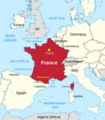
File:France and its region.png

Page contents not supported in other languages.
This is a file from the Wikimedia Commons
From Wikipedia, the free encyclopedia

Original file(794 × 909 pixels, file size: 326 KB, MIME type: image/png)

Summary

Description
English: France and its neighbors
Date
Source Modified File:France in European Union (-rivers -mini map).svg
Author Thinker78, based on map by TUBS
Permission
(Reusing this file)
Thinker78 (based on map by TUBS), the copyright holder of this work, hereby publishes it under the following license:
w:en:Creative Commons
attribution
This file is licensed under the Creative Commons Attribution 4.0 International license.
Attribution: Thinker78 (based on map by TUBS)
You are free:
  • to share – to copy, distribute and transmit the work
  • to remix – to adapt the work
Under the following conditions:
  • attribution – You must give appropriate credit, provide a link to the license, and indicate if changes were made. You may do so in any reasonable manner, but not in any way that suggests the licensor endorses you or your use.
Other versions
w:en:Creative Commons
attribution share alike
This file is licensed under the Creative Commons Attribution-Share Alike 3.0 Unported license.
Attribution: TUBS
You are free:
  • to share – to copy, distribute and transmit the work
  • to remix – to adapt the work
Under the following conditions:
  • attribution – You must give appropriate credit, provide a link to the license, and indicate if changes were made. You may do so in any reasonable manner, but not in any way that suggests the licensor endorses you or your use.
  • share alike – If you remix, transform, or build upon the material, you must distribute your contributions under the same or compatible license as the original.
I'd greatly appreciate, that you attribute this media file to Wikimedia Commons, if used outside Wikipedia or Commons. For use in publications such as books, newspapers, blogs, websites, please insert here the following line:
{{published|author= |date= |url= |title= |org= }}
and fill the applicable fields. (Example). License terms given above still apply.

বাংলা  Deutsch  Deutsch (Sie-Form)  Ελληνικά  English  español  français  Ἀρχαία ἑλληνικὴ  Bahasa Indonesia  日本語  македонски  Nederlands  português  русский  Türkçe  简体中文  繁體中文  +/−

Camera location47° 00′ 00″ N, 2° 00′ 00″ E Kartographer map based on OpenStreetMap.View this and other nearby images on: OpenStreetMapinfo

Made with w:LibreOffice Draw

Licensing

Thinker78 (based on map by TUBS), the copyright holder of this work, hereby publishes it under the following license:
w:en:Creative Commons
attribution
This file is licensed under the Creative Commons Attribution 4.0 International license.
Attribution: Thinker78 (based on map by TUBS)
You are free:
  • to share – to copy, distribute and transmit the work
  • to remix – to adapt the work
Under the following conditions:
  • attribution – You must give appropriate credit, provide a link to the license, and indicate if changes were made. You may do so in any reasonable manner, but not in any way that suggests the licensor endorses you or your use.

Captions

France and its surrounding region

13 May 2023

image/png

File history

Click on a date/time to view the file as it appeared at that time.

Date/TimeThumbnailDimensionsUserComment
current02:50, 11 April 2024Thumbnail for version as of 02:50, 11 April 2024794 × 909 (326 KB)Thinker78added locations, improved format
02:33, 5 September 2023Thumbnail for version as of 02:33, 5 September 2023712 × 831 (231 KB)Thinker78Added places names (Corsica, Sardinia, Gulf of Lion, Catalonia)
07:36, 13 May 2023Thumbnail for version as of 07:36, 13 May 2023650 × 805 (197 KB)Thinker78Uploaded a work by Thinker78, TUBS from File:France in European Union (-rivers -mini map).svg with UploadWizard
The following pages on the English Wikipedia use this file (pages on other projects are not listed):

Global file usage

The following other wikis use this file: