
File:Kiev on 1804 map.jpg
No higher resolution available.
Kiev_on_1804_map.jpg (272 × 208 pixels, file size: 21 KB, MIME type: image/jpeg)
| Description |
|
|---|---|
| Source |
|
| Date |
c. 1804 |
| Author |
Cary, John, ca. 1754-1835 |
| Permission (Reusing this file) |
See below.
|
| This file is in the public domain because its copyright has expired in the United States and those countries with a copyright term of no more than the life of the author plus 100 years.
|
| The uploader or another editor requests that a local copy of this file be kept. This image or media file may be available on the Wikimedia Commons as File:Kiev on 1804 map.jpg. While the license of this file may be compliant with the Wikimedia Commons, an editor has requested that the local copy be kept too. This file does not meet CSD F8 and should not be tagged as a Commons duplicate. If you desire to nominate it for deletion, notify the tagging editor. |
File history
Click on a date/time to view the file as it appeared at that time.
| Date/Time | Thumbnail | Dimensions | User | Comment | |
|---|---|---|---|---|---|
| current | 04:59, 27 May 2007 | | 272 × 208 (21 KB) | Irpen (talk | contribs) | |
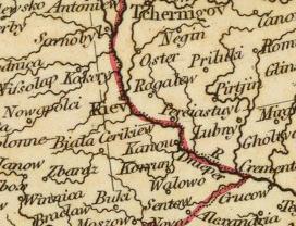
| 06:43, 26 May 2007 |  | 1,189 × 852 (1.01 MB) | Irpen (talk | contribs) | *A fragment of the old map. *Original full title of the map: A new map of Europe, from the latest authorities. By John Cary, engraver, 1804. London: Published by J. Cary, Engraver & Map-seller, No. 181, Strand, Novr. 28, 1804. *Author: [[John Cary|Cary, |
You cannot overwrite this file.
File usage
The following file is a duplicate of this file (more details):
- File:1804ம் ஆண்டு நில வரைபடத்தில் கீவ்.jpg from Commons
The following pages on the English Wikipedia use this file (pages on other projects are not listed):