
File:Museum Of Tolerance.png
Size of this preview: 547 × 599 pixels. Other resolutions: 219 × 240 pixels | 606 × 664 pixels.
Original file (606 × 664 pixels, file size: 995 KB, MIME type: image/png)
| This is a file from the Wikimedia Commons. Information from its description page there is shown below. Commons is a freely licensed media file repository. You can help. |
Summary
| Description |
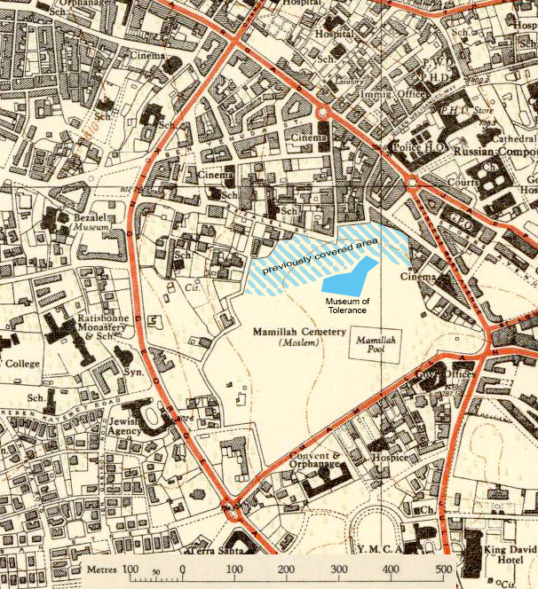
English: The base map was published by the Survey of Palestine in 1946. The solid blue shape is the Museum of Tolerance, whose construction began in 2007. The hatched blue area and some of the solid blue area was already covered by buildings or paving before 2006. |
| Date | |
| Source |
Survey of Palestine map 1946 Survey of Israel aerial photo 2022 (for accurate location only) |
| Author | Survey of Palestine |
Licensing
This work created by the United Kingdom Government is in the public domain.
This is because it is one of the following:
HMSO has declared that the expiry of Crown Copyrights applies worldwide (ref: HMSO Email Reply)
|
 |
File history
Click on a date/time to view the file as it appeared at that time.
| Date/Time | Thumbnail | Dimensions | User | Comment | |
|---|---|---|---|---|---|
| current | 03:40, 9 January 2023 | | 606 × 664 (995 KB) | Zero0000 | Uploaded a work by Survey of Palestine from Survey of Palestine map 1946 Survey of Israel aerial photo 2022 (for accurate location only) with UploadWizard |
File usage
The following pages on the English Wikipedia use this file (pages on other projects are not listed):