
File:Population Density by Pakistani District - 2017 Census.svg

Original file (SVG file, nominally 3,200 × 2,000 pixels, file size: 2.43 MB)
| This is a file from the Wikimedia Commons. Information from its description page there is shown below. Commons is a freely licensed media file repository. You can help. |
Summary
| Description |
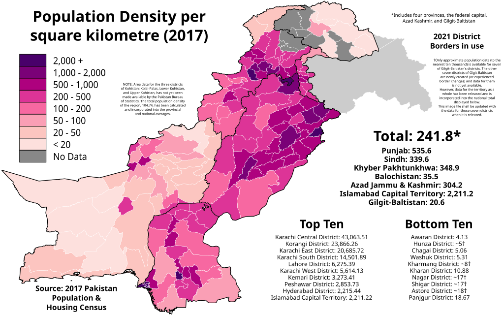
English: The map above shows the population density (per square kilometre) of each Pakistani district according to the final official results of the 2017 Pakistan Population & Housing Census. The data can be found here for the four provinces and ICT, here for Azad Kashmir, and here for Gilgit-Baltistan.
NOTE: Only approximate data (to the nearest ten thousand) is available for seven of Gilgit-Baltistan's districts. The other seven districts of Gilgit-Baltistan are newly created (or experienced border changes) and data for them is not yet available. However, data for the territory as a whole has been released and is incorporated into the national total displayed below. This image file shall be updated with the data for those seven districts when it is released. NOTE: Area data for the three districts of Kohistan: Kolai-Palas, Lower Kohistan, and Upper Kohistan, has not yet been made available by the Pakistan Bureau of Statistics. The total population density of the region, 104.74, has been calculated and incorporated into the provincial and national averages. Legend 2,000+
1,000 - 1,500
500 - 1,000
200 - 500
100 - 200
50 - 100
20 - 50
< 20 |
| Date | |
| Source |
This file was derived from: Blank Districts of Pakistan.svg: |
| Author | Abbasi786786 |
Licensing
- You are free:
- to share – to copy, distribute and transmit the work
- to remix – to adapt the work
- Under the following conditions:
- attribution – You must give appropriate credit, provide a link to the license, and indicate if changes were made. You may do so in any reasonable manner, but not in any way that suggests the licensor endorses you or your use.
- share alike – If you remix, transform, or build upon the material, you must distribute your contributions under the same or compatible license as the original.
File history
Click on a date/time to view the file as it appeared at that time.
| Date/Time | Thumbnail | Dimensions | User | Comment | |
|---|---|---|---|---|---|
| current | 15:42, 20 March 2022 | | 3,200 × 2,000 (2.43 MB) | Abbasi786786 | Fix typo |
| 00:06, 5 August 2021 |  | 3,200 × 2,000 (2.43 MB) | Abbasi786786 | Added Gilgit-Baltistan Data, Improved Template | |
| 18:26, 7 June 2021 |  | 3,200 × 2,000 (1.54 MB) | Abbasi786786 | Uploaded own work with UploadWizard |
File usage
Global file usage
The following other wikis use this file:
- Usage on ko.wikipedia.org