
File:West Asia Köppen Map.png
Size of this preview: 502 × 599 pixels. Other resolutions: 201 × 240 pixels | 402 × 480 pixels | 990 × 1,182 pixels.
Original file (990 × 1,182 pixels, file size: 511 KB, MIME type: image/png)
| This is a file from the Wikimedia Commons. Information from its description page there is shown below. Commons is a freely licensed media file repository. You can help. |
| Peel, M. C. and Finlayson, B. L. and McMahon, T. A. (2007). "Updated world map of the Köppen-Geiger climate classification". Hydrol. Earth Syst. Sci. 11: 1633-1644. ISSN 1027-5606. |
Legend
Summary
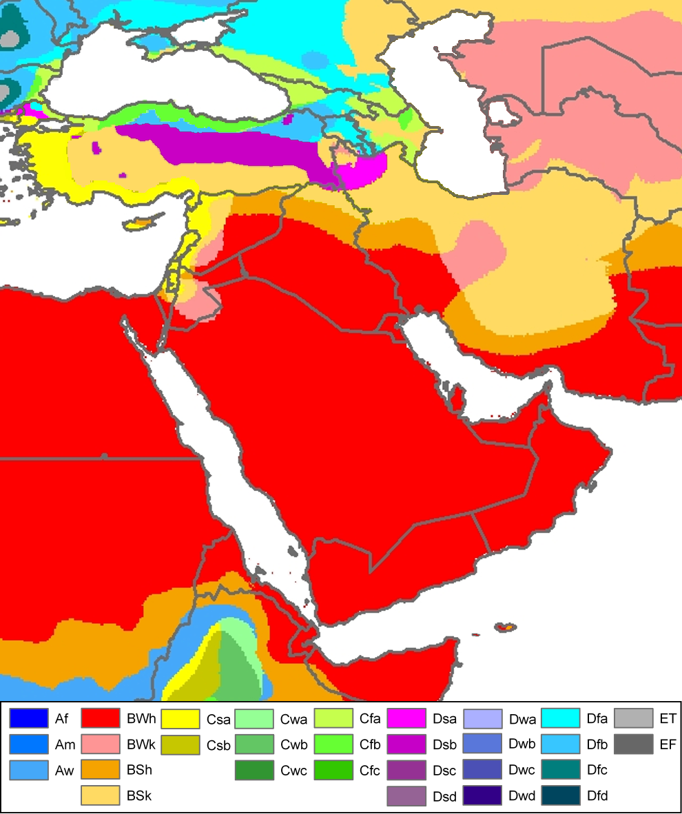
| Description | Climate map of (South)west-Asia and adjacent areas (from the "Updated world map of the Köppen-Geiger climate classification"). |
| Date | |
| Source | Hydrology and Earth System Sciences: "Updated world map of the Köppen-Geiger climate classification" (Supplement) - Original file was a JPG-file, this file is has been converted to a PNG-file, without extra modifications, by me (Jeroen). |
| Author |
Peel, M. C., Finlayson, B. L., and McMahon, T. A. (University of Melbourne) |
| Permission (Reusing this file) |

|
This meteorology image could be re-created using vector graphics as an SVG file. This has several advantages; see Commons:Media for cleanup for more information. If an SVG form of this image is available, please upload it and afterwards replace this template with
{{vector version available|new image name}}.
It is recommended to name the SVG file “West Asia Köppen Map.svg”—then the template Vector version available (or Vva) does not need the new image name parameter. |
Related maps
User Jeroenvrp made for these continents and areas a cropped and resized version:
- Africa Köppen Map.png
- Asia Köppen Map.png
- Australia-Oceania Köppen Map.png
- Europe Köppen Map.png
- North America Köppen Map.png
- Russia Köppen Map.png
- South America Köppen Map.png
- West Asia Köppen Map.png.
User LordToran made from the same data these maps:
- Klimagürtel-der-erde-eisklima.png
- Klimagürtel-der-erde-gemäßigte-zone.png
- Klimagürtel-der-erde-polargebiete.png
- Klimagürtel-der-erde-subtropen.png
- Klimagürtel-der-erde-tropen.png
- Klimagürtel-der-erde-tundra.png
- Klimagürtel-der-erde-warmgemäßigte-zone.png
- Klimagürtel-der-erde.png
- Klimagürtel-der-erde.svg
- Klimate-humidität.png
- Köppen-geiger-hessd-2007.svg
- Köppen-vereinfacht.svg
- Trockenklimate.png
Licensing
This file is licensed under the Creative Commons Attribution-Share Alike 3.0 Unported license.
- You are free:
- to share – to copy, distribute and transmit the work
- to remix – to adapt the work
- Under the following conditions:
- attribution – You must give appropriate credit, provide a link to the license, and indicate if changes were made. You may do so in any reasonable manner, but not in any way that suggests the licensor endorses you or your use.
- share alike – If you remix, transform, or build upon the material, you must distribute your contributions under the same or compatible license as the original.
File history
Click on a date/time to view the file as it appeared at that time.
| Date/Time | Thumbnail | Dimensions | User | Comment | |
|---|---|---|---|---|---|
| current | 12:57, 21 November 2016 | | 990 × 1,182 (511 KB) | Pandakekok9 | Transparent |
| 12:23, 13 March 2011 |  | 990 × 1,182 (543 KB) | Maphobbyist | Painted the Caspian Sea as white as it should have been, because the Köppen system is based on the concept that climate types are correlated with the natural vegetation. Thus with Köppen, climate zone boundaries have been selected with vegetation distri | |
| 23:01, 12 October 2007 |  | 990 × 1,182 (507 KB) | Jeroen | Citation: '''Peel, M. C., Finlayson, B. L., and McMahon, T. A.: Updated world map of the Köppen-Geiger climate classification, Hydrol. Earth Syst. Sci., 11, 1633-1644, 2007.''' {{Information |Description= Climate map of North-America (from the "[[:Ima |
File usage
The following pages on the English Wikipedia use this file (pages on other projects are not listed):
Global file usage
The following other wikis use this file:
- Usage on af.wikipedia.org
- Usage on ar.wikipedia.org
- Usage on de.wikipedia.org
- Usage on eo.wikipedia.org
- Usage on es.wikipedia.org
- Usage on es.wikibooks.org
- Usage on eu.wikipedia.org
- Usage on fy.wikipedia.org
- Usage on ha.wikipedia.org
- Usage on hy.wikipedia.org
- Usage on it.wikipedia.org
- Usage on ja.wikipedia.org
- Usage on ja.wikibooks.org
- Usage on nl.wikipedia.org
- Usage on nn.wikipedia.org
- Usage on oc.wikipedia.org
- Usage on ro.wikipedia.org
- Usage on sl.wikipedia.org
- Usage on sr.wikipedia.org
- Usage on te.wikipedia.org
- Usage on th.wikipedia.org
- Usage on uk.wikipedia.org
- Usage on vi.wikipedia.org