
I'billin
I'billin
| |
|---|---|
| Hebrew transcription(s) | |
| • ISO 259 | ʔiˁblin |
 | |
 Coat of arms | |
 I'billin  I'billin | |
| Coordinates: 32°49′21″N 35°11′32″E / 32.82250°N 35.19222°E | |
| Grid position | 168/247 PAL |
| Country | |
| District | Northern |
| Area | |
| • Total | 18,000 dunams (18 km2 or 7 sq mi) |
| Population (2022)[1] | |
| • Total | 13,843 |
| • Density | 770/km2 (2,000/sq mi) |
I'billin (Arabic: إعبلين, Hebrew: אִעְבְּלִין)[2] is a local council in the Northern District of Israel, near Shefa-'Amr.[3] 'Ibillin was granted municipal status in 1960. The municipality's area is 18,000 dunams. In 2022 its population was 13,843, all of whom are Arab Israelis with a mixed population of Muslims and Christians.[4]
History[edit]
Archaeological excavations in the centre of the village has indicated a continuous inhabitation from the 9th century BCE during the Iron Age, to the 14th century CE during the Mamluk period.[5]
Roman period[edit]
Archaeological evidence indicates that this was a Jewish settlement in ancient times, and findings include ritual baths and hiding complexes used during the First Jewish–Roman War.[5] I'billin has been identified with the Jewish town of Evlayim or Abelim, which is attested in various Talmudic sources from the third century CE.[5][6][7]
A notable discovery in I'billin is a synagogue lintel dating back to the fourth to sixth centuries CE. This artifact, repurposed as a step on the street leading to the village church, bears a text that can be translated to, "Remembered for the good is Baruch the Alexandrian(?) or son of Nehorai(?) who here supported (contributed) and made this gate. Amen. Peace."[7]
Fatimid period[edit]
Nasir Khusraw visited the place in 1047 CE: "From Damum we passed south to another village, called A'bilin, where there is the tomb of Hud - peace be upon him! - which I visited. Within the enclosure here is a mulberry tree, and there is likewise the tomb of the prophet Uzair - peace be upon him! - which I also visited."[8]
Ottoman period[edit]
18th century[edit]
In 1760, a traveller between Acre and Nazareth noted "the castle of Abelin, on a beautiful eminence; and a town close to it, which is governed by Joseph Omar, brother of the chief of Acre", by the latter meaning Zahir al-Umar.[9] The castle, still standing in the town, is probably from the eighteenth century.[10]
In 1799, I'billin was marked Obellin on Jacotin's map surveyed during Napoleon's invasion.[11]
19th century[edit]

In 1848, William F. Lynch, head of the American expedition to the River Jordan, met there Aqil Agha, and made him their guide.[12] Aqil Agha built a fortress[dubious ] in Ibillin.[13] He is buried in the village, as is the family of Dhaher el-Omar.
The population in 1859 was stated by British consul Edward Thomas Rogers to have been 800 souls, and the tillage fifty feddans.[14]
In 1875, the French explorer Victor Guérin visited the village. He estimated the population at 600, divided equally between Moslems and "Greek Christians", the latter subdivided into Melkite and Greek Orthodox Christians. He noted that the latter had a church dedicated to St. George.[15]
In 1881, the PEF's Survey of Western Palestine (SWP) described it as "A village on high ground with gardens beneath it on the south, and a spring ('Ain 'Afieh) about half a mile to the south. There is a minaret to the mosque which is a conspicuous object." According to an Arabic inscription on the mosque, the construction of the mosque and the remains of a fortification in the village are credited to Yusef el-Omar, a Zaydani family member and brother of the 18th century ruler of the Galilee, Zahir al-Umar. According to the SWP, "The houses in the village are principally of stone; wells occur south of the hill, with olives near them. Some of the inhabitants are Greek Christians."[14]
A population list from about 1887 showed that Abelin had about 745 inhabitants; 400 Greek Catholic Christians, 70 Catholic Christians, 30 Latin Christians and 245 Muslims.[16]
British Mandate[edit]
In the 1922 census of Palestine conducted by the British Mandate authorities, I'billin had 528 Christians and 289 Muslims, a total population of 817.[17] Of the Christians, 410 were Orthodox, 111 Melkite and 7 Anglican.[18] In the 1931 census 'Arab El Hujeirat was counted together with I'billin, and the census found 663 Christians and 453 Muslims, a total 1116 persons, in 192 houses.[19]
In the 1945 statistics the population of I'billin was 1,660; 1,060 Christians and 600 Muslims,[20] who owned 18,632 dunams of land according to an official land and population survey.[21] 2,367 dunams were plantations and irrigable land, 8,628 used for cereals,[22] while 95 dunams were built-up (urban) land.[23]
Israel[edit]
I'billin was captured by the Israeli army during the first phase of Operation Dekel, 8–14 July 1948.[24] Most of the Muslim population were expelled and replaced by Christians from neighbouring villages.[25] The town was regularly searched for people who were not registered in the November 1948 census. On 8 January 1949 villagers from I'billin were amongst a group of 128 men, women and children, who were expelled into the West Bank at 'Ara.[26] The town remained under martial law until 1966.
.jpg)
Religious communities[edit]

The village is of special importance to Catholics as the birthplace of Mariam Baouardy or Bawardi (1846-1878), who was beatified by Pope John Paul II in 1983[27] and canonized by Pope Francis in 2015.[28] Saint Mariam Bawardi is considered as one of the two first Palestinian saints, the other being Marie-Alphonsine Danil Ghattas.
Education[edit]

In 1965 Abuna Elias Chacour, an Arab Christian from Kafr Bir'im, later Archbishop of Galilee, established a school open to all local children, regardless of religious affiliation. This developed into the Mar Elias Educational Institutions, an educational complex consisting of a kindergarten, elementary school, junior high school, high school. And formerly used to include a college and a university. The educational complex is located on Jabal al-Ghoul (Hill of Demons), on property belonging to the Melkite Church. The hill has been renamed Jabal al-Nour (Hill of Light).[29]
"Mar Elias University" was established in 2003, claiming to be the first Arab university in Israel, though it is not officially holding a University status. It is recognized by the Council for Higher Education in Israel as a campus and operates as a branch of the University of Indianapolis in the United States.[29] But the Israeli government ordered its closure hence it was turned into Mar Elias High School, part of the Mar Elias Educational Institutions.
Economy[edit]
Ibillin historically depended on agriculture, especially the growth of sheets and vegetables (most notably cucumbers). Ibillin is also one of only municipalities in Israel that are allowed to raise pigs and to house pig farms on its land[30] and it exports to multiple Arab Christian and Russian restaurants and factories all throughout Israel who sell pork products (most notably the Russian "Marcel Brothers - אחים מרסל" company based in Haifa).
Ibillin also relies on tourism to the Daoud Courtyard Open Air Museum, where one can visit the house of Saint Mariam Bawardi.
Notable businesses in Ibillin:
- Naser Recycling (Arabic: شركة ناصر لإعادة تدوير النفايات "Naser Company for Waste Recycling", Hebrew: נאסר מיחזור), the only privately owned waste management company in Israel. Based in Ibillin, it owns and operates a waste handling complex (located in Ibillin) that includes a municipal solid waste separation plant, a compost plant, a landfill and an electricity generator powered by methane gas.
- Mar Elias Educational Institutions (Arabic: مؤسسات مار الياس التعليميّة): educational complex consisting of a kindergarten, elementary school, junior high school, high school. The Institution is owned by Abuna Elias Chacour.
- Daoud Courtyard (Arabic: متحف دار داود, Hebrew: חצר דאוד): One of the last heritage complexes in the Galilee villages. The complex is 120 years old[31] and includes the house of Saint Mariam Bawardi, the Daoud family house and garden (one of the first and oldest buildings still standing in Ibillin built during the British Mandate of Palestine), and a Palestinian olive oil press.
- Shaheen Honey (Arabic: عسل شاهين).
Notable people[edit]
- Aqil Agha (c. 1820–1870), Galilean strongman
- Mariam Baouardy (1846–1878), Catholic saint
- Elias Chacour (born 1939) Former Archbishop of the Melkite Catholic Church for Akko, Haifa, Nazareth, and all Galilee
- Shawqi Habib (1929–2018), (ar:شوقي_حبيب) Chemistry Teacher, Writer, Poet, First Arab to graduate from the Technion Israel Institute of Technology
- Saleh Saleem (born 1953), former politician
- Miriam Toukan (born 1982), singer
Gallery[edit]
-
 A panoramic view of the house of Saint Mariam Bawardi of Ibillin
 -
 The Old Town Mosque of Ibillin in the old town.
 -
 Old Church of Ibillin.
 -
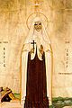 Saint Mariam Baouardy (Mary of Jesus Crucified).


See also[edit]
References[edit]
- ^ "Regional Statistics". Israel Central Bureau of Statistics. Retrieved 21 March 2024.
- ^ From a personal name, according to Palmer, 1881, p. 105
- ^ Kashti, Or (2008-09-08). "Mar Elias schools: Investing in excellence". Haaretz.com. Retrieved 2013-04-25.
- ^ אעבלין 2014
- ^ a b c Abu Raya, 2012, ‘Ibillin Preliminary Report
- ^ Avi-Yonah, Michael (1976). "Gazetteer of Roman Palestine". Qedem. 5: 25. ISSN 0333-5844.
- ^ a b "XC. Abelim (mod. Iʾbillin)", Volume 5/Part 1 Galilaea and Northern Regions: 5876-6924, De Gruyter, pp. 678–680, 2023-03-20, doi:10.1515/9783110715774-098/html, ISBN 978-3-11-071577-4, retrieved 2024-02-07
- ^ Nasir Khusraw quoted in Le Strange, 1890, p. 382.
- ^ Mariti, 1792, p. 343
- ^ Pringle, 1997, p. 51
- ^ Karmon, 1960, p. 162 Archived 2019-12-22 at the Wayback Machine
- ^ Lynch, 1849, pp. 140-144
- ^ Jampoler, 2005, p. 120[dead link]
- ^ a b Conder and Kitchener, 1881, SWP I, p. 269
- ^ Guérin, 1880, pp. 420-421, as translated by Conder and Kitchener, 1881, SWP I, p. 270
- ^ Schumacher, 1888, p. 176
- ^ Barron, 1923, Table XI, Sub-District of Haifa, p. 33
- ^ Barron, 1923, Table XVI, p. 49
- ^ Mills, 1932, p. 91
- ^ Government of Palestine, Village Statistics 1945, p. 14
- ^ Government of Palestine, Department of Statistics. Village Statistics, April, 1945. Quoted in Hadawi, 1970, p. 48
- ^ Government of Palestine, Department of Statistics. Village Statistics, April, 1945. Quoted in Hadawi, 1970, p. 90
- ^ Government of Palestine, Department of Statistics. Village Statistics, April, 1945. Quoted in Hadawi, 1970, p. 140
- ^ Morris, 1987, p. 198
- ^ Pappe, 2006, p. 159
- ^ Morris, 1993, p. 145
- ^ "The Carmelite Web Site - O.Carm". Archived from the original on May 18, 2008. Retrieved 2008-11-15.
- ^ St. Mary of Jesus Crucified (OCD), Virgin (mf) Archived 2018-08-29 at the Wayback Machine, at the website of Order of the brothers of the Most Blessed Virgin Mary of Mt. Carmel. Accessed 2020-09-21.
- ^ a b "On campus at Ibillin". Mec.sahrat.net. Archived from the original on 2012-04-26. Retrieved 2013-04-25.
- ^ "Agriculture Ministry Seeking to Move All of Israel's Pig Farms to Country's South". Haaretz. Retrieved July 21, 2019.
- ^ "Daoud Courtyard homepage and about". Daoud Courtyard. Retrieved July 21, 2019.
Bibliography[edit]
- Abu Raya, Rafeh (2012-04-19). "'Ibillin Preliminary Report" (124). Hadashot Arkheologiyot – Excavations and Surveys in Israel.
{{cite journal}}: Cite journal requires|journal=(help) - Barron, J. B., ed. (1923). Palestine: Report and General Abstracts of the Census of 1922. Government of Palestine.
- Conder, C.R.; Kitchener, H.H. (1881). The Survey of Western Palestine: Memoirs of the Topography, Orography, Hydrography, and Archaeology. Vol. 1. London: Committee of the Palestine Exploration Fund.
- Department of Statistics (1945). Village Statistics, April, 1945. Government of Palestine.
- Guérin, V. (1880). Description Géographique Historique et Archéologique de la Palestine (in French). Vol. 3: Galilee, pt. 1. Paris: L'Imprimerie Nationale.
- Hadawi, S. (1970). Village Statistics of 1945: A Classification of Land and Area ownership in Palestine. Palestine Liberation Organization Research Center.
- Jampoler, Andrew C. A. (2005). Sailors in the Holy Land: The 1848 American Expedition to the Dead Sea and the Search for Sodom and Gomorrah. Naval Institute Press. p. 120. ISBN 9781591144137. Retrieved 27 December 2011.
- Karmon, Y. (1960). "An Analysis of Jacotin's Map of Palestine" (PDF). Israel Exploration Journal. 10 (3, 4): 155–173, 244–253. Archived from the original (PDF) on 2019-12-22. Retrieved 2015-03-23.
- Lynch, W.F. (1849). Narrative of the United States' Expedition to the River Jordan and the Dead Sea. London: Richard Bentley.
- Mariti, Giovanni (1792). Travels Through Cyprus, Syria, and Palestine; with a General History of the Levant. Vol. 1. Dublin: P. Byrne.
- Mills, E., ed. (1932). Census of Palestine 1931. Population of Villages, Towns and Administrative Areas. Jerusalem: Government of Palestine.
- Morris, B. (1993). Israel's Border Wars, 1949 - 1956. Arab Infiltration, Israeli Retaliation, and the Countdown to the Suez War. Oxford University Press. ISBN 0-19-827850-0.
- Morris, B. (1987). The Birth of the Palestinian refugee problem, 1947-1949. Cambridge University Press. ISBN 0-521-33028-9.
- Palmer, E.H. (1881). The Survey of Western Palestine: Arabic and English Name Lists Collected During the Survey by Lieutenants Conder and Kitchener, R. E. Transliterated and Explained by E.H. Palmer. Committee of the Palestine Exploration Fund.
- Pappé, I. (2006). The Ethnic Cleansing of Palestine. London and New York: Oneworld. ISBN 1-85168-467-0.
- Pringle, D. (1997). Secular buildings in the Crusader Kingdom of Jerusalem: an archaeological Gazetter. Cambridge University Press. ISBN 0521-46010-7.
- Schumacher, G. (1888). "Population list of the Liwa of Akka". Quarterly Statement - Palestine Exploration Fund. 20: 169–191.
- Strange, le, G. (1890). Palestine Under the Moslems: A Description of Syria and the Holy Land from A.D. 650 to 1500. Committee of the Palestine Exploration Fund., London,
External links[edit]
- Welcome To I'billin
- Survey of Western Palestine, Map 5: IAA, Wikimedia commons
- Local Council of Ibillin (Arabic)
- Pilgrims of Ibillin (organization in the USA)
- Daoud Courtyard, Ibillin Museum and location of the house of St. Mariam Baouardy.
| Cities | .svg) | ||||
|---|---|---|---|---|---|
| Local councils |
| ||||
| Regional councils |
| ||||