
Jerusalem corridor

The Jerusalem corridor (Hebrew: פרוזדור ירושלים, Prozdor Yerushalayim) is an area between Jerusalem and the Shephelah in Israel. Its northern border is the old road to Jerusalem; its southern border, the Elah Valley; and its western border, Sha'ar HaGai/Bab el-Wad and the road to Beit Shemesh. The largest towns in the Jerusalem corridor are Beit Shemesh, Mevasseret Zion, Abu Ghosh, Tzur Hadassah and Kiryat Ye'arim.
History[edit]

Historically, terrace farming had been practiced on the hills and in the narrow valleys and wadis of the area.[citation needed]
During the 1947-48 war, the Jerusalem corridor was the only route for bringing supplies to besieged Jerusalem.[citation needed] In the Battle of Latrun, Jewish forces attempted to capture the former British police fort at Latrun, where Jordanian forces were stationed.[citation needed] The so-called Burma Road was built as an alternative.[citation needed] In October 1948, Israeli troops brought the area under their control during Operation Ha-Har. The Arab inhabitants fled their villages during the war.[citation needed]
As of 1949, the mountainous, rocky region of the corridor was bare of trees.[citation needed] In the first decade of the State of Israel, a total of 35 agricultural settlements were established in the Jerusalem corridor by new immigrants from Yemen, Kurdistan, North Africa, Romania and Hungary.[citation needed] The JNF employed many of the newcomers in afforestation and land reclamation. Since then it has become one of the largest afforested regions in the country.[citation needed]
-
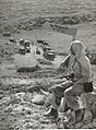 Burma Road convoy
 -
 Arab ambush on a Jewish convoy truck
 -
 Arab ambush on a Jewish convoy truck
 -
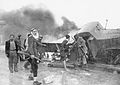
 Aftermath of Arab ambush on a Jewish convoy truck
 -
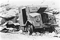
 1947–1949 Palestine war truck wreck. June 7, 1950, Jerusalem Corridor


Modern roads and railway in the area[edit]
Today, in addition to the Jerusalem – Tel Aviv highway (Highway 1), a number of additional routes lead to Jerusalem; route 443 covers the northern part of the corridor. Route 395 leads from Ein Kerem to the coast, via Ramat Raziel and Bet Shemesh, and continues south. Route 386 leads to the Ella Valley, via Bar Giora and Tzur Hadassa. A railway line is active in the corridor, next to the Sorek Stream, which is part of the historical Jaffa–Jerusalem railway.