
Kırşehir Province
Kırşehir Province
Kırşehir ili | |
|---|---|
 Kentpark in Kırşehir | |
 Location of the province within Turkey | |
| Country | Turkey |
| Seat | Kırşehir |
| Government | |
| • Governor | Hüdayar Mete Buhara |
| Area | 6,584 km2 (2,542 sq mi) |
| Population (2022)[1] | 244,519 |
| • Density | 37/km2 (96/sq mi) |
| Time zone | UTC+3 (TRT) |
| Area code | 0386 |
| Website | www |
Kırşehir Province (Turkish: Kırşehir ili) is a province in central Turkey, forming part of the Central Anatolia Region. Its area is 6,584 km2,[2] and its population is 244,519 (2022).[1] It stands on the North Anatolian Fault, and is currently in an earthquake warning zone. The average elevation is approximately 985 meters above sea level. The provincial capital is Kırşehir. The geographical centre of all land surfaces on Earth is at 39°00′N 34°00′E / 39.000°N 34.000°E, in Kırşehir Province, Turkey.[3]
Kırşehir Province was originally established in 1924. On 30 June 1954, the province of Kırşehir was demoted from a province to parts of other provinces of [citation needed] Nevşehir Province,Ankara Province and Yozgat Province the ruling Democrat Party government of Prime Minister Adnan Menderes, because the majority of the city's residents had voted for the Republican Nation Party led by opposition politician Osman Bölükbaşı in the 1954 Turkish general election on 2 May 1954. Three years later, on 1 July 1957, Kırşehir Province was re-established.
The provincial center Kırşehir is the 69th largest city by population in Turkey; its surface area corresponds to 0.84% of Turkey's land area, which makes it the 53rd largest city in the country by land area.[4]
Districts[edit]

Kırşehir province is divided into 7 districts (the capital district is in bold):
Places of Interest[edit]
- Üçayak Byzantine Church
- Kilise Kalıntıları, "Church ruins" in Demirli, Kaman.
Gallery[edit]
-
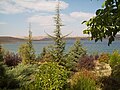 View of Lake Çoğun
 -
 Türbe of Yunus Emre in Ulupınar
 -
 The fields of Boztepe in Kırşehir Province
 -
 The ruins of the Üçayak Byzantine Church
 -
 The remains of a church in Demirli, Kaman.


See also[edit]
References[edit]
- ^ a b "Address-based population registration system (ADNKS) results dated 31 December 2022, Favorite Reports" (XLS). TÜİK. Retrieved 19 September 2023.
- ^ "İl ve İlçe Yüz ölçümleri". General Directorate of Mapping. Retrieved 19 September 2023.
- ^ Woods, Andrew J. (1973). The Center of the Earth. I.C.R. Technical Monographs. Vol. 3. London: I.C.R.
- ^ GLHN (2022-07-23). "Kırşehir". Ansiklopedika Viki (in Turkish). Archived from the original on 2022-10-13. Retrieved 2022-09-18.
External links[edit]
![]() Media related to Kırşehir Province at Wikimedia Commons
Media related to Kırşehir Province at Wikimedia Commons
- (in Turkish) Kırşehir governor's official website
- (in Turkish) Kırşehir municipality's official website
- (in English) Kırşehir weather forecast information
- Kırşehir tourist information
- Kırşehir information web pages
- Kırşehir Haber
39°19′26″N 34°07′45″E / 39.32389°N 34.12917°E


| International | |
|---|---|
| National | |
| Geographic | |
| Other | |
This geographical article about a location in Kırşehir Province, Turkey is a stub. You can help Wikipedia by expanding it. |