
Kfar Yehoshua
Kfar Yehoshua
כְּפַר יְהוֹשֻׁעַ | |
|---|---|
 | |
| Etymology: Joshua Village | |
 Kfar Yehoshua | |
| Coordinates: 32°41′1″N 35°9′14″E / 32.68361°N 35.15389°E | |
| Country | Israel |
| District | Northern |
| Council | Jezreel Valley |
| Affiliation | Moshavim Movement |
| Founded | 1927 |
| Population (2022)[1] | 1,251 |

Kfar Yehoshua (Hebrew: כְּפַר יְהוֹשֻׁעַ, lit. 'Joshua's Village') is a moshav in northern Israel. Located between Haifa and Nazareth, it falls under the jurisdiction of Jezreel Valley Regional Council. In 2022 it had a population of 1,251.[1]
History[edit]
Ottoman era[edit]
Near the village there is an archaeological site called Tell esh Shemmâm. During Ottoman era a Muslim village was found there. The meaning of the name is "Mound of the Melon/Colocynth".[2] Moshe Dayan mentioned it as an example of "there is not one place built in this country which did not have a former Arab population".[3]
In 1881, the PEF's Survey of Western Palestine (SWP) described Tel esh Shemmam as a small artificial mound.[4]
British Mandate era[edit]
In the 1922 census of Palestine conducted by the British authorities, Tal al-Shammam had 71 inhabitants; 70 Muslims and 1 Melkite Christian.[5][6] A nearby swamp called el-Matba'ah was believed to provide relief from rheumatism, nervous pains, and sterility.[7]
The area was acquired by the Jewish community as part of the Sursock Purchase. The moshav was founded in 1927,[8] based on an agreement reached in 1923 at a Histadrut committee meeting in Nahalal. In 1924, during the Shavuot holidays, the council met in order to clarify the ideological goal of combining the idea of the kibbutz and the moshav. In 1924, a contract for the purchase of land in the western Jezreel Valley was signed under the auspices of Yehoshua Hankin.[9] A tract of 8,000 dunams was purchased for 25,000 Egyptian pounds from the heirs of the Twsiny family (partners of the Sursocks). The village at the time was the home of 50 families.[10] In January 1927, the committee voted to name the village for Hankin. On March 3, 1927, the wooden hut of the former tenants of the railway station in Tel Shamam was brought to the hill of the village and the first families took up residence there.[9]
Kfar Yehoshua was one of 140 agricultural settlements designed by the German-Jewish architect Richard Kauffmann.[11]
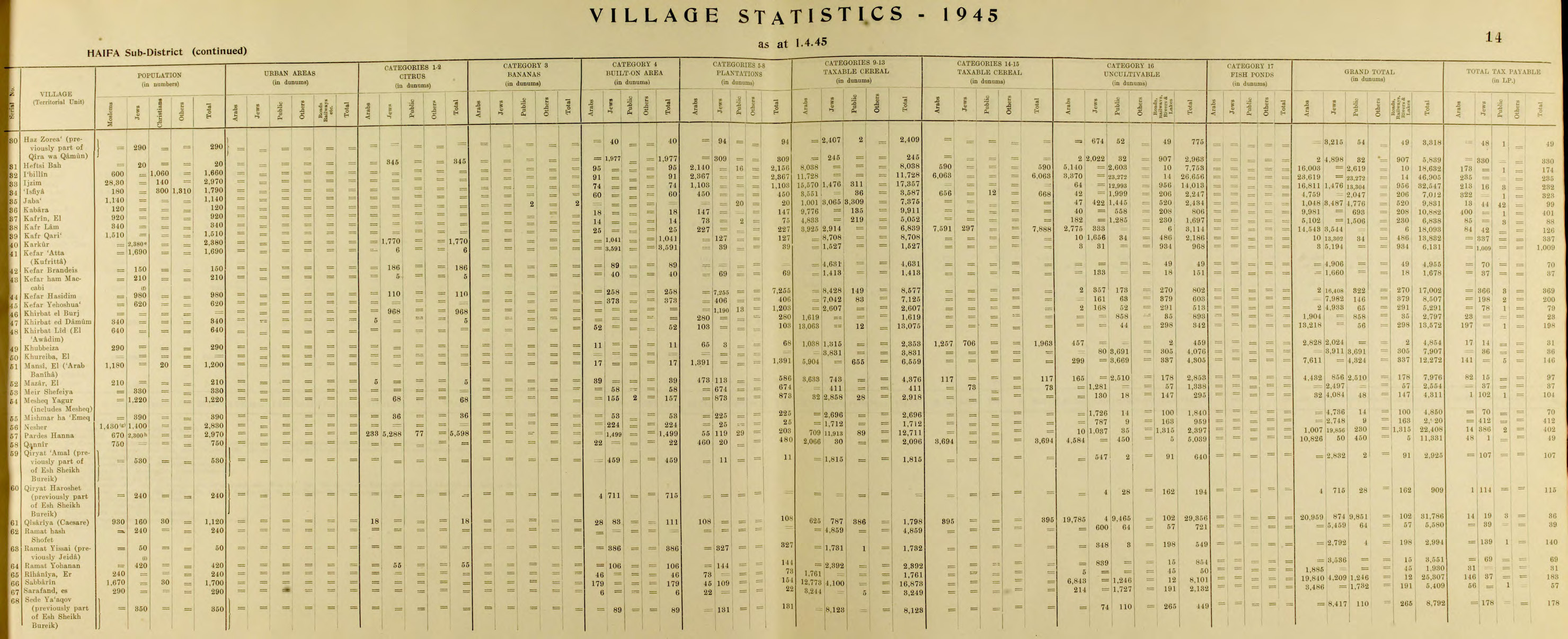
In the 1931 census Kfar Yehoshua had a population of 277; 32 Muslim and 245 Jews, in a total of 53 inhabited houses.[12] In the 1945 statistics, the population was 620, all Jewish.[13][14]
-
 Kfar Yehoshus 1929
 -
 Kfar Yehoshua 1939
 -
 Kfar Yehoshua 1946 station in foreground
 -
 Kfar Yehoshua railway station 1930


Landmarks[edit]
A train station in Kfar Yehoshua operated for close to fifty years on the Jezreel Valley Railway, from the beginning of the 20th century to 1948. Seven stone buildings from this period have been restored by the Society for Preservation of Israel Heritage Sites,[dubious ] and original railroad tracks have been returned to the site.[15]
Notable people[edit]
References[edit]
- ^ a b "Regional Statistics". Israel Central Bureau of Statistics. Retrieved 21 March 2024.
- ^ Palmer, 1881, p. 117
- ^ cited in Rogan and Shlaim, 2001, p. 207
- ^ Conder and Kitchener, 1881, SWP I, p. 353
- ^ Barron, 1923, Table XI, Sub-district of Haifa, p. 33
- ^ Barron, 1923, Table XVI, p. 49
- ^ Tewfik Canaan (1927). Mohammedan Saints and Sanctuaries in Palestine. Jerusalem: Ariel Publishing House. p. 111.
- ^ Levy, Eyal (3 February 2012). בכפר יהושע המומים מההתאבדות של כוכב הריאליטי [Kfar Yehoshua residents stunned by suicide of reality star]. Nrg Maariv (in Hebrew). Retrieved 5 February 2012.
כפר יהושע הוקם ב-1927 ונמצא בעמק יזרעאל, שני קילומטרים דרומית לרמת ישי.
- ^ a b Roads Lead to Kfar Yehoshua, Elie Shamir[permanent dead link]
- ^ List of villages sold by Sursocks and their partners to the Zionists since the British occupation of Palestine. Palestine Commission on the Disturbances of August 1929, Exhibit No. 71, minutes of evidence page 1074.
- ^ Sonder, Ines (April 10, 2006). "He Planned Afula and Nahalal, but Who Remembers?". Haaretz. Retrieved August 4, 2019.
- ^ Mills, 1932, p. 98
- ^ Department of Statistics, 1945, p. 14
- ^ Government of Palestine, Department of Statistics. Village Statistics, April, 1945. Quoted in Hadawi, 1970, p. 48
- ^ Gilad, Moshe (August 15, 2012). "In the Footsteps of Israel's Founding Fathers". Haaretz. Retrieved August 4, 2018.
Bibliography[edit]
- Barron, J.B., ed. (1923). Palestine: Report and General Abstracts of the Census of 1922. Government of Palestine.
- Conder, C.R.; Kitchener, H.H. (1881). The Survey of Western Palestine: Memoirs of the Topography, Orography, Hydrography, and Archaeology. Vol. 1. London: Committee of the Palestine Exploration Fund.
- Department of Statistics (1945). Village Statistics, April, 1945. Government of Palestine.
- Hadawi, S. (1970). "Village Statistics of 1945: A Classification of Land and Area ownership in Palestine". Palestine Liberation Organization Research Center.
{{cite journal}}: Cite journal requires|journal=(help) (p.49) - Mills, E., ed. (1932). Census of Palestine 1931. Population of Villages, Towns and Administrative Areas. Jerusalem: Government of Palestine.
- Palmer, E.H. (1881). The Survey of Western Palestine: Arabic and English Name Lists Collected During the Survey by Lieutenants Conder and Kitchener, R. E. Transliterated and Explained by E.H. Palmer. Committee of the Palestine Exploration Fund.
- Rogan, E.; Shlaim, A. (2001). The War for Palestine: Rewriting the History of 1948. Cambridge University Press. ISBN 0-521-79476-5.
External links[edit]
- Survey of Western Palestine, Map 5: IAA, Wikimedia commons
- Kfar Yehoshua Collection on the Digital collections of Younes and Soraya Nazarian Library, University of Haifa
| International | |
|---|---|
| National | |