
Kutaisi
Kutaisi
ქუთაისი | |
|---|---|
-cropped.jpg) .jpg) .jpg) Top to bottom: Downtown Kutaisi & White Bridge as seen from Mt Gora, A downtown street, Bagrati Cathedral in 2014 | |
 Kutaisi Kutaisi (Imereti)  Kutaisi Kutaisi (Imereti) | |
| Coordinates: 42°15′0″N 42°42′0″E / 42.25000°N 42.70000°E | |
| Country | |
| Region (Mkhare) | Imereti |
| Established | 13th century BC[a][b] |
| Government | |
| • Type | Mayor–Council |
| • Body | Kutaisi City Assembly |
| • Mayor | Ioseb Khakhaleishvili (GD) [3] |
| Area | |
| • Total | 67.7 km2 (26.1 sq mi) |
| Elevation | 80 m (260 ft) |
| Population (2023 census)[4] | |
| • Total | 130,411 |
| • Estimate (2020) | 135,201 |
| • Density | 1,900/km2 (5,000/sq mi) |
| Population by ethnicity[5] | |
| • Georgians | 99.0 % |
| • Russians | 0.36 % |
| • Ukrainians | 0.10 % |
| • Armenians | 0.09 % |
| Time zone | UTC+4 (Georgian Time) |
| Postal code | 4600-4699 |
| Area code | (+995) 431 |
| Climate | Cfa |
| Website | kutaisi |
 | |


Kutaisi (/kuːˈtaɪsiː/ koo-TIE-see,[6] Georgian: ქუთაისი pronounced [kʰutʰaisi] ⓘ) is one of the oldest continuously inhabited cities in the world and the third-most populous city in Georgia after Tbilisi and Batumi. Situated 221 kilometres (137 miles) west of Tbilisi, on the Rioni River, it is the capital of the western region of Imereti.
Historically one of the major cities of Georgia, it served as political center of Colchis in the Middle Ages as capital of the Kingdom of Abkhazia[7] and Kingdom of Georgia and later as the capital of the Kingdom of Imereti. From October 2012 to December 2018, Kutaisi was the seat of the Parliament of Georgia as an effort to decentralise the Georgian government.
History[edit]
Archaeological evidence indicates that the city functioned as the capital of the Colchis in the sixth to fifth centuries BC.[8] It is believed that, in Argonautica, a Greek epic poem about Jason and the Argonauts and their journey to Colchis, author Apollonius Rhodius considered Kutaisi their final destination as well as the residence of King Aeëtes.

Later, it was the capital of the kingdom of Lazica until being occupied briefly by the Arabs. An Arab incursion into western Georgia was repelled by Abkhazians jointly with Lazic and Iberian allies in 736, towards c.786, Leon II won his full independence from Byzantine and transferred his capital to Kutaisi, thus unifying Lazica and Abasgia via a dynastic union. The latter led the unification of the Georgian monarchy in the 11th century.
From 1008 to 1122, Kutaisi served as the capital of the United Kingdom of Georgia, and, from the 15th century until 1810, it was the capital of the Imeretian Kingdom. In 1508, the city was conquered by Selim I, who was the son of Bayezid II, the sultan of the Ottoman Empire.
During the 17th century, Imeretian kings made many appeals to Russian Empire to help them in their struggle for independence from the Ottomans. All these appeals were ignored as Russia did not want to spoil relations with Turkey. Only in the reign of Catherine the Great, in 1768, were troops of general Gottlieb Heinrich Totleben sent to join the forces of King Heraclius II of Georgia, who hoped to reconquer the Ottoman-held southern Georgian lands, with Russian help. Totleben helped King Solomon I of Imereti to recover his capital, Kutaisi, on August 6, 1770.
.JPG)
Finally, the Russian-Turkish wars ended in 1810 with the annexation of the Imeretian Kingdom by the Russian Empire. The city was the administrative capital of the Kutais Uyezd and the larger Kutaisi Governorate, which included much of west Georgia.
In March 1879, the city was the site of a blood libel trial that attracted attention all over the Russian Empire. Nine Georgian Jews from Sachkhere were falsely accused of killing a Christian girl and using her blood for allegedly Jewish religious purposes.[9] The trial took place at the Kutaisi Circuit Court, which had been established in 1868 as one of several new courts in the Caucasus created by Tsar Alexander II.'s Judicial Reform. After a ten-day trial, with nearly 70 witnesses, the nine defendants were acquitted as the defence lawyers Petr Aleksandrov and Lev Kupernik convinced the judges that the accusations against the Jewish men were mostly based on false testimony.[9]
Kutaisi was a major industrial center before Georgia's independence on 9 April 1991. Independence was followed by the economic collapse of the country, and, as a result, many inhabitants of Kutaisi have had to work abroad. Small-scale trade prevails among the rest of the population.
In 2011, Mikheil Saakashvili, the president of Georgia, signed a constitutional amendment relocating the parliament to Kutaisi.[10] On 26 May 2012, Saakashvili inaugurated the new Parliament building in Kutaisi. This was done in an effort to decentralise power and shift some political control closer to Abkhazia, although it has been criticised as marginalising the legislature, and also for the demolition of a Soviet War Memorial formerly at the new building's location.[11] The subsequent government of the Georgian Dream passed a new constitution that moved the parliament back to Tbilisi, effective from January 2019.[12]
Culture[edit]
.jpg)

Landmarks[edit]
The landmark of the city is the ruined Bagrati Cathedral, built by Bagrat III, king of Georgia, in the early 11th century. The Gelati Monastery a few km east of the city, is a UNESCO World Heritage Site. One of the famous churches in Georgia is Motsameta monastery. It is named after two saints, brothers David and Constantine. They were the Dukes of Margveti, and were martyred by Arab invaders in the 8th century. Besides the churches, there are other places of note such as: Sataplia Cave, where one can observe footprints of dinosaurs; ruins of Geguti Palace, which was one of the residences of Georgian monarchs; "Okros Chardakhi" – Georgian Kings' Palace; the Pantheon, where many notable citizens are buried; The Kutaisi Synagogue which was built in 1885.
-
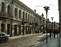 A street in central Kutaisi
 -
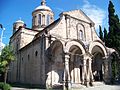 Church of Annunciation
 -
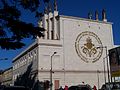
 Court of Appeals
 -
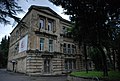
 Kutaisi Public School
 -
 Local synagogue built in 1886
 -
 Kutaisi State Opera
 -


.jpg)


Museums and other cultural institutions[edit]

- Kutaisi State Historical Museum
- Kutaisi Museum of Sport
- Kutaisi Museum of Martial Art
- Museum of Zakaria Paliashvili
- Kutaisi State Historical Archive
- Kutaisi State Scientific-Universal Library
- Akaki Tsereteli State University
- David Kakabadze Kutaisi Fine Art Gallery
Theatres and cinema[edit]
.jpg)
- Kutaisi Lado Meskhishvili State Academic Theatre
- Kutaisi Meliton Balanchivadze State Opera House
- Kutaisi Iakob Gogebashvili State Puppet Theatre
- Cinema and Entertaining Center "Suliko"
- Hermann-Wedekind-Jugendtheater
Education[edit]
Higher educational institutions in Kutaisi:
- Akaki Tsereteli State University
- Kutaisi International University
- Georgian State University of Subtropical Agriculture
- Kutaisi University (Unik)
Professional unions and public organizations[edit]
- Georgian Writers' Union
- Georgian Painters' Union
- Folk Palace
Media[edit]
Local newspapers include: Kutaisi, Imeretis Moabe, Akhali Gazeti, and Kutaisuri Versia. Other publications include Chveneburebi, a journal published by the Ministry of Diaspora Issues, and Gantiadi, a scientific journal.
TV: "Rioni"; Radio: "Dzveli Kalaki" (old City)
Also nearly all of Georgia's national-level newspapers, journals and television stations have their representatives in Kutaisi.
Geography[edit]

Kutaisi is located along both banks of the Rioni River. The city lies at an elevation of 125–300 metres (410–984 feet) above sea level. To the east and northeast, Kutaisi is bounded by the Northern Imereti Foothills, to the north by the Samgurali Range, and to the west and the south by the Colchis Plain.
Landscape[edit]
Kutaisi is surrounded by deciduous forests to the northeast and the northwest. The low-lying outskirts of the city have a largely agricultural landscape. The city center has many gardens and its streets are lined with high, leafy trees. In the springtime, when the snow starts to melt in the nearby mountains, the storming Rioni River in the middle of the city is heard far beyond its banks.
Climate[edit]
Kutaisi has a humid subtropical climate (Cfa) with a well-defined on-shore/monsoonal flow (characteristic of the Colchis Plain) during the autumn and winter months. The summers are generally hot, while the winters are wet and cool. The average annual temperature in the city is 14.8 °C (58.6 °F). January is the coldest month with an average temperature of 5.4 °C (41.7 °F) while August is the hottest month with an average temperature of 24.7 °C (76.5 °F). The absolute minimum recorded temperature is −17.0 °C (1.4 °F) and the absolute maximum is 43.1 °C (109.6 °F) recorded on 30 July 2000.[13]
Average annual precipitation is around 1,500 mm (59.06 in). Rain may fall in every season of the year. The city often experiences heavy, wet snowfall (snowfall of 30 cm / 12 in or more per single snowstorm is not uncommon) in the winter, but the snow cover usually does not last for more than a week. There are roughly 15.5 days a year with snow depth.[13] Kutaisi experiences powerful easterly winds in the summer which descend from the nearby mountains.
| Climate data for Kutaisi (normals 1991–2020 extremes 1981-2020) | |||||||||||||
|---|---|---|---|---|---|---|---|---|---|---|---|---|---|
| Month | Jan | Feb | Mar | Apr | May | Jun | Jul | Aug | Sep | Oct | Nov | Dec | Year |
| Record high °C (°F) | 21.4 (70.5) |
23.8 (74.8) |
29.0 (84.2) |
33.9 (93.0) |
37.6 (99.7) |
39.0 (102.2) |
43.1 (109.6) |
42.2 (108.0) |
40.0 (104.0) |
35.2 (95.4) |
28.6 (83.5) |
24.6 (76.3) |
43.1 (109.6) |
| Mean daily maximum °C (°F) | 9.7 (49.5) |
10.9 (51.6) |
14.7 (58.5) |
19.9 (67.8) |
24.5 (76.1) |
27.6 (81.7) |
29.4 (84.9) |
30.2 (86.4) |
27.0 (80.6) |
22.3 (72.1) |
16.0 (60.8) |
11.6 (52.9) |
20.3 (68.6) |
| Daily mean °C (°F) | 6.1 (43.0) |
6.5 (43.7) |
9.6 (49.3) |
13.9 (57.0) |
18.4 (65.1) |
22.0 (71.6) |
24.3 (75.7) |
24.8 (76.6) |
21.6 (70.9) |
17.3 (63.1) |
11.7 (53.1) |
8.0 (46.4) |
15.4 (59.6) |
| Mean daily minimum °C (°F) | 3.7 (38.7) |
3.6 (38.5) |
6.2 (43.2) |
9.7 (49.5) |
14.0 (57.2) |
17.8 (64.0) |
20.5 (68.9) |
20.7 (69.3) |
17.6 (63.7) |
13.8 (56.8) |
8.8 (47.8) |
5.5 (41.9) |
11.8 (53.3) |
| Record low °C (°F) | −9.2 (15.4) |
−9.8 (14.4) |
−5.3 (22.5) |
−2.1 (28.2) |
2.6 (36.7) |
8.5 (47.3) |
13.0 (55.4) |
12.1 (53.8) |
8.6 (47.5) |
3.0 (37.4) |
−1.0 (30.2) |
−6.7 (19.9) |
−9.8 (14.4) |
| Average precipitation mm (inches) | 138.2 (5.44) |
117.0 (4.61) |
133.8 (5.27) |
86.0 (3.39) |
84.7 (3.33) |
101.1 (3.98) |
86.4 (3.40) |
77.6 (3.06) |
116.5 (4.59) |
144.9 (5.70) |
129.2 (5.09) |
142.8 (5.62) |
1,358.2 (53.48) |
| Average precipitation days (≥ 1.0 mm) | 12.5 | 11.1 | 12.5 | 9.9 | 9.2 | 8.9 | 8.8 | 7.4 | 8.3 | 9.5 | 10.4 | 11.4 | 119.9 |
| Average relative humidity (%) | 70.2 | 70.5 | 70.4 | 69.2 | 70.9 | 73.3 | 75 | 74 | 71.5 | 70.2 | 69.3 | 69.2 | 71.1 |
| Source: NOAA NCEI[13] | |||||||||||||
| Climate data for Kutaisi (normals and extremes 1981–2010) | |||||||||||||
|---|---|---|---|---|---|---|---|---|---|---|---|---|---|
| Month | Jan | Feb | Mar | Apr | May | Jun | Jul | Aug | Sep | Oct | Nov | Dec | Year |
| Record high °C (°F) | 21.4 (70.5) |
22.8 (73.0) |
29.0 (84.2) |
33.9 (93.0) |
37.6 (99.7) |
39.0 (102.2) |
43.1 (109.6) |
42.0 (107.6) |
40.0 (104.0) |
35.2 (95.4) |
28.6 (83.5) |
24.6 (76.3) |
43.1 (109.6) |
| Mean daily maximum °C (°F) | 9.2 (48.6) |
10.1 (50.2) |
14.2 (57.6) |
19.9 (67.8) |
23.9 (75.0) |
26.9 (80.4) |
28.6 (83.5) |
29.3 (84.7) |
26.4 (79.5) |
21.8 (71.2) |
15.8 (60.4) |
11.4 (52.5) |
19.8 (67.6) |
| Daily mean °C (°F) | 5.6 (42.1) |
5.9 (42.6) |
9.0 (48.2) |
13.8 (56.8) |
17.8 (64.0) |
21.2 (70.2) |
23.6 (74.5) |
24.0 (75.2) |
20.9 (69.6) |
16.7 (62.1) |
11.4 (52.5) |
7.7 (45.9) |
14.8 (58.6) |
| Mean daily minimum °C (°F) | 3.2 (37.8) |
3.1 (37.6) |
5.6 (42.1) |
9.6 (49.3) |
13.4 (56.1) |
17.1 (62.8) |
19.9 (67.8) |
20.1 (68.2) |
16.9 (62.4) |
13.3 (55.9) |
8.5 (47.3) |
5.2 (41.4) |
11.3 (52.3) |
| Record low °C (°F) | −6.6 (20.1) |
−9.8 (14.4) |
−5.3 (22.5) |
−2.1 (28.2) |
2.6 (36.7) |
8.5 (47.3) |
13.0 (55.4) |
12.1 (53.8) |
8.7 (47.7) |
3.0 (37.4) |
−0.5 (31.1) |
−6.7 (19.9) |
−9.8 (14.4) |
| Average precipitation mm (inches) | 164.7 (6.48) |
121.4 (4.78) |
129.6 (5.10) |
88.0 (3.46) |
91.3 (3.59) |
110.0 (4.33) |
98.0 (3.86) |
96.6 (3.80) |
114.6 (4.51) |
148.4 (5.84) |
145.8 (5.74) |
152.5 (6.00) |
1,461 (57.52) |
| Average precipitation days (≥ 0.1 mm) | 11.7 | 13.8 | 13.8 | 13.3 | 12.1 | 11.9 | 13.6 | 11.6 | 10.8 | 10.3 | 11.8 | 14.5 | 149.2 |
| Average relative humidity (%) | 68 | 68 | 69 | 66 | 69 | 72 | 76 | 75 | 74 | 71 | 65 | 64 | 70 |
| Source 1: World Meteorological Organization[14] | |||||||||||||
| Source 2: Deutscher Wetterdienst (days with precipitation and humidity)[15] | |||||||||||||
Population[edit]

| Year | Georgians | Jews | Armenians | Russians | Others | Total | |||||
|---|---|---|---|---|---|---|---|---|---|---|---|
| 1886[16] | 15,200 | 67.1% | 2.788 | 12.3% | 2,320 | 10.2% | 1,526 | 6.7% | 22,643 | ||
| 1897[17][18] | 22,017 | 67.8% | 3,419 | 10.5% | 1,264 | 3.9% | 3,684 | 11.3% | 32,476 | ||
| 1916[19] | 33,843 | 58.2% | 10,479 | 18.0% | 1,845 | 3.2% | 10,975 | 18.9% | 1,009 | 1.7% | 58,151 |
| 1926[16][20] | 39,871 | 82.7% | 4,738 | 9.8% | 830 | 1.7% | 890 | 1.8% | 48,196 | ||
| 1939[16][21] | 59,612 | 76.9% | 6,986 | 4.7% | 977 | 1.3% | 8,753 | 11.3% | 77,515 | ||
| 1959[16][22] | 96,614 | 75.4% | 581 | 0.5% | 1,614 | 1.3% | 16,213 | 12.6% | 128,203 | ||
| 1970[23] | 160,937 | ||||||||||
| 1979[24] | 194,297 | ||||||||||
| 1989[25] | 234,870 | ||||||||||
| 2002[26] | 181,465 | 97.6% | 613 | 0.3% | 2,223 | 1.2% | 1,664 | 0.9% | 185,965 | ||
| 2014[27] | 146,153 | 99.00% | 60 | 0.04% | 127 | 0.09% | 533 | 0.36% | 762 | 0.52% | 147,635 |
| 2023[28] | 130,411 | ||||||||||
Administrative division[edit]

There are 13 administrative units in Kutaisi:
- Avtokarkhana
- Gamarjveba
- Gumati
- Vakisubani
- Kakhianouri
- Mukhnari
- Nikea
- Sapichkhia
- Sulkhan-Saba
- Ukimerioni
- City-museum
- Dzelkviani
- Zastava
Government[edit]
Mayor[edit]
.jpg)
The most recent mayoral election was held on 2 October 2021, with a runoff held on 30 October, and the results were as follows:
| Candidate | Party | First round | Second round | |||
|---|---|---|---|---|---|---|
| Votes | % | Votes | % | |||
| Khatia Dekanoidze | United National Movement | 28,325 | 43.33 | 32,703 | 48.36 | |
| Ioseb Khakhaleishvili | Georgian Dream | 27,093 | 41.45 | 34,925 | 51.64 | |
| Giorgi Goguadze | For Georgia | 5,698 | 8.72 | |||
| Andro Losaberidze | Strategy Aghmashenebeli | 3,276 | 5.01 | |||
| Irina Saghinadze | Free Georgia | 971 | 1.49 | |||
| Total | 65,363 | 100.00 | 67,628 | 100.00 | ||
| Valid votes | 65,363 | 95.51 | 67,628 | 96.58 | ||
| Invalid/blank votes | 3,074 | 4.49 | 2,396 | 3.42 | ||
| Total votes | 68,437 | 100.00 | 70,024 | 100.00 | ||
| Registered voters/turnout | 153,861 | 44.48 | 153,726 | 45.55 | ||
| Source: CEC, CEC | ||||||
List of elected mayors of Kutaisi [c]
- Ioseb Khakhaleishvili (GD) (2020–)
- Giorgi Chighvaria (GD) (2017–2020)
- Shota Murghulia (GD) (2014–2017)
City council[edit]

The Kutaisi city council (Sakrebulo) governs the city alongside the Mayor. The most recent city council election was held on October 2, 2021, and the results were as follows:
| Party | Lead candidate | Votes | % | +/- | Seats | +/- | ||
|---|---|---|---|---|---|---|---|---|
| Georgian Dream | Dimitri Mkheidze | 25,957 | 39.21 | 18 | ||||
| United National Movement | Giga Shushania | 24,893 | 37.60 | 14 | ||||
| For Georgia | Eleonora Archaia | 4,440 | 6.71 | New | 2 | New | ||
| Strategy Aghmashenebeli | Koba Guruli | 2,168 | 3.28 | 1 | ||||
| Lelo | Gia Gurgenidze | 1,339 | 2.02 | New | 0 | New | ||
| Labour Party | Samson Gugava | 1,130 | 1.71 | 0 | ||||
| Girchi - More Freedom | Dachi Dididze | 1,073 | 1.62 | New | 0 | New | ||
| For the People | Shota Chikovani | 820 | 1.24 | New | 0 | New | ||
| Alliance of Patriots | Nona Asatiani | 804 | 1.21 | 0 | ||||
| European Georgia | David Gogisvanidze | 733 | 1.11 | 0 | ||||
| Total | 68,486 | 100.0 | 35 | ±10 | ||||
| Electorate/voter turnout | 153,861 | 44.53 | ||||||
| Source: არჩევნების შედეგები | ||||||||
Economy[edit]

Kutaisi has traditionally been an important industrial center in Georgia, but after the collapse of the Soviet Union most of the old manufacturing lines either stopped working or had to greatly reduce their operations. Nevertheless, the city continues to be an important regional center for the greater Imereti area, acting as a commercial hub for the surrounding countryside. In recent years, the city has started attracting more investment from various multinational corporations.
The Auto Mechanical Plant, originally established in 1945, is located in Kutaisi.
There are two free industrial zones in Kutaisi: The Kutaisi free industrial zone (Kutaisi FIZ) and the Hualing free industrial zone (Hualing FIZ).[29] The Kutaisi FIZ was created in 2009 and was established on the initiative of Fresh Electric, an Egypt-based home appliances producer.[30] The Hualing FIZ operates since 2015, and specializes in wood and stone processing, furniture and mattress production and metal construction. Both of the free industrial zones offer multiple incentives to investors such as tax exemptions and reduced barriers for trade.[29]
In 2019, German solar panel manufacturer AE Solar opened a new, fully automated manufacturing line in Kutaisi. With a total output of 500 MW per year it is the largest solar panel factory under one roof in Europe.[31] During the same year Changan Automobile announced plans to construct an electric car factory in Kutaisi, with an annual production capacity of up to 40,000 vehicles. The company plans to export annually about 20,000 cars to the EU.[32] The factory plans to employ about 3,000 people.[33]
Sport[edit]
Kutaisi has a great tradition in sports, with many famous sports clubs. FC Torpedo Kutaisi has participated on the highest level of the Soviet Union football league. After Georgia achieved independence, it won many domestic and international titles. RC AIA Kutaisi won the Soviet Championship several times in rugby, and after independence, national championships and cups. The women's football club FC Martve takes part at the 2017–18 UEFA Women's Champions League qualifying round after becoming champion in the Georgia women's football championship in 2016.[34] Kutaisi also has an influential basketball club BC Kutaisi 2010, 2016 Champion of the Georgian Superliga, which plays its home games at the Kutaisi Sport Palas.
Transport[edit]
Airport[edit]
David the Builder Kutaisi International Airport (IATA: KUT, ICAO: UGKO) is an airport located 14 km (8.70 mi) west of Kutaisi. It is one of three international airports currently in operation in Georgia.
Railway[edit]
Kutaisi has two main railway stations, along with multiple smaller ones. Direct inter-city, as well as suburban railway services, are provided to Tbilisi (Central) and other major cities across the country. The rail operator on all lines is Georgian Railways.
Local celebrations[edit]

Kutaisoba is the most important holiday in Kutaisi. It is celebrated on 2 May. On this day the population of Kutaisi crowds into the central park, with their children and celebrate together.
Some people make masks and there are many kinds of performances. Also, children sell chamomiles. It is an old tradition, in the past ladies collected money for poor people, so today children also collect money for them.
On Kutaisoba one can see traditional Georgian dances and can hear folk music. Also, it is an old tradition to go to the forest, which is near Kutaisi. Families barbecue and play games. On this day, people wear traditional clothes, choxa. There is a tradition of writing lyrics that have been written by writers from Kutaisi, and then airplanes throw them from the sky. There is also a competition in different kinds of martial arts.
Notable people[edit]

- Aeëtes – King of Kingdom of Colchis
- Bagrat III – King of united Kingdom of Georgia in 975–1014
- George I – King of united Kingdom of Georgia in 1014–1027
- Bagrat IV – King of united Kingdom of Georgia in 1027–1072
- George II – King of united Kingdom of Georgia in 1072–1089
- David IV – King of united Kingdom of Georgia in 1089–1125
- Veriko Anjaparidze – Georgian actress
- Revaz Gabriadze – cinematographer, writer, director, production designer
- Niko Nikoladze (1843–1928) – Georgian public figure
- Meliton Balanchivadze (1862–1937) – Georgian composer
- Zakaria Paliashvili (1871–1933) – Georgian composer
- Iakob Nikoladze (1876–1951) – Georgian sculptor, designer of the previous state flag of Georgia.
- Władysław Raczkiewicz (1885–1947) – the first president of the Polish government-in-exile, 1939–1947
- Joseph Orbeli (1887–1961) – orientalist
- David Kakabadze (1889–1952) – Georgian painter
- Victor Dolidze (1890–1933) – Georgian composer
- Petre Otskheli (1907–1937) Georgian modernist set and costume designer
- Otar Korkia (1923–2005) – Georgian basketball player and coach (Olympic silver medalist)
- Dodo Chichinadze (1924–2009) – Georgian actress
- Revaz Dzodzuashvili (b. 1945) – Georgian football player, World Cup 1966 bronze medalist
- Zurab Sakandelidze (b. 1945) – Georgian basketball player, Olympic champion
- Mikheil Korkia (b. 1948) – Georgian basketball player, Olympic champion
- Meir Pichhadze (1955–2010) – Israeli painter, Kutaisi native
- Tengiz Sulakvelidze (b. 1956) – Georgian football player, played in 1982 FIFA World Cup, Euro 1988 silver medalist
- Ramaz Shengelia (1957–2012) – Georgian football player, played in 1982 FIFA World Cup
- Maia Chiburdanidze (b. 1961) – the seventh Women's World Chess Champion
- Besik Khamashuridze (b. 1977) – Georgian rugby player, won 53 caps, RC Aia Kutaisi player-coach
- David Khakhaleishvili (b. 1971) – Olympic champion in Wrestling
- Davit Aslanadze (b.1976) – Football player
- Katie Melua (b. 1984) – Georgian British singer and songwriter
- Roland Shalamberidze (b. 1958) – Georgian artist
- Nika Sichinava (b. 1994) – Georgian football player, played for Yunist Chernihiv and FC Inhulets Petrove.
International relations[edit]
Twin towns – sister cities[edit]

 Ashkelon, Israel
 Columbia, United States
 Dnipro, Ukraine
 Ganja, Azerbaijan
 Gomel, Belarus
 Karşıyaka, Turkey
- Kharkiv, Ukraine
 Laiwu (Jinan), China
- Lviv, Ukraine
- Mykolaiv, Ukraine
- Nanchang, China
 Newport, Wales, UK
 Poznań, Poland
- Sumy, Ukraine
 Szombathely, Hungary
 Ungheni, Moldova
 Valka, Latvia
- Zhytomyr, Ukraine
Cooperation agreements[edit]
Kutaisi has cooperation agreements with:[35]
See also[edit]
Explanatory notes[edit]
- ^ “Aia is the city of Colchis. It is located on the edge of the populated universe" (footnote to the book "Argonauts II" by Apollonius). “Aia – the city of Colchis, built by Aeetes at a distance of three hundred stadiums from the sea” (Stephanus of Byzantium, the Ethnica, summary).[1]
- ^ კოლხეთი ხშირად ეყოფოდა საქართველოს სამეფოს. მას საკუთარი მეფეებიც ჰყავდა, მაგალითად, ჰეტიუსი, რომელიც არგონავტთა ლაშქრობამდე მეფობდა აქ, და მისი ძე რეტა I, ვინც არგონავტები მიიღო (1292 ძვ. წ.)[2]
- ^ Prior to the 2014 Local self-governance reform, mayors were elected by the city assembly.
References[edit]
- ^ Toponymy as Documentary Material Confirming Historical and Cultural Kinship (Astionym “Kutaia/Kutaisi” and aspects of centuries-old relations between Greece and Georgia). IAI Academic Conference Proceedings, Venice, 27 March 2023. p.p. 23-26.
- ^ მიხეილ თამარაშვილი „ქართული ეკლესია დასაბამიდან დღემდე“. საქართველოს პარლამენტის ეროვნული ბიბლიოთეკა, წიგნადი ფონდი. გვერდი 86.
- ^ "The Mayor of Kutaisi: iosib khakhaleishvili". Kutasai Municipality. Archived from the original on 2020-12-31. Retrieved 2021-01-12.
- ^ "Population - National Statistics Office of Georgia". www.geostat.ge.
- ^ "Ethnic composition of Georgia 2014". mashke.org. Archived from the original on 2018-11-04.
- ^ ""Kutaisi", Dictionary.com". Archived from the original on 2018-04-16. Retrieved 2018-04-15.
- ^ Bondyrev, Igor V; Davitashvili, Zurab V; Singh, V. P (2015). The geography of Georgia: problems and perspectives. ISBN 978-3-319-05413-1. OCLC 912320815.
- ^ Gela Gamkrelidze. RESEARCHES IN IBERIA-COLCHOLOGY. Edited by David Braiind (Prof, of University of Exeter (UK)) // Olar LORDKIPANIDZE CENTRE OF ARCHAEOLOGY OF GEORGIAN NATIONAL MUSEUM. P. 43 "According to the data on archaeological excavations on the Gabashvili, Dateshidze and Ukimerioni hills in Kutaisi, an urban-type settlement of the 6-5 cent. BC was found to be concentrated"
- ^ a b Kirmse, Stefan B. (9 February 2024). "Russian imperial borderlands, Georgian Jews, and the struggle for 'justice' and 'legality': blood libel in Kutaisi, 1878–80". Central Asian Survey: 1–25. doi:10.1080/02634937.2024.2302581.
- ^ Relocation of Next Parliament to Kutaisi Endorsed, Civil Georgia, Tbilisi, 21 June 2011 Archived 13 September 2016 at the Wayback Machine.Retrieved: 24 November 2013.
- ^ "Georgia opens new parliament in Kutaisi, far from the capital". Washington Post. 26 May 2012. Archived from the original on 2018-12-11. Retrieved 26 May 2012.
- ^ "New Constitution of Georgia comes into play as the presidential inauguration is over". Agenda.ge. 17 December 2018. Archived from the original on 27 November 2020. Retrieved 4 January 2021.
- ^ a b c "World Meteorological Organization Climate Normals for 1991-2020: Georgia-Qutaisi" (CSV). NOAA. Retrieved 2023-12-29.
- ^ "World Meteorological Organization Climate Normals for 1981–2010". World Meteorological Organization. Archived from the original on 9 October 2021. Retrieved 9 October 2021.
- ^ "Klimatafel von Kutaisi / Georgien" (PDF). Baseline climate means (1961-1990) from stations all over the world (in German). Deutscher Wetterdienst. Archived (PDF) from the original on 21 December 2019. Retrieved 14 February 2016.
- ^ a b c d "население грузии". Archived from the original on February 8, 2008. Retrieved October 8, 2016.
- ^ "Демоскоп Weekly – Приложение. Справочник статистических показателей". Archived from the original on August 18, 2016. Retrieved October 8, 2016.
- ^ "Батумский округ 1897". Archived from the original on May 9, 2013. Retrieved October 8, 2016.
- ^ Кавказский календарь на 1917 год [Caucasian calendar for 1917] (in Russian) (72nd ed.). Tiflis: Tipografiya kantselyarii Ye.I.V. na Kavkaze, kazenny dom. 1917. pp. 198–205. Archived from the original on 4 November 2021.
- ^ Кутаисский Уезд (1926 г.). ethno-kavkaz.narod.ru. Archived from the original on 2020-09-24. Retrieved 2020-04-23.
- ^ Кутаисский Район (1939 г.). ethno-kavkaz.narod.ru. Archived from the original on 2020-02-16. Retrieved 2020-04-23.
- ^ Всесоюзная перепись населения 1959 г. Численность городского населения союзных республик (кроме РСФСР), их территориальных единиц, городских поселений и городских районов по полу [All-Union Population Census 1959 The size of the urban population of the Union republics (except for the RSFSR), their territorial units, urban settlements and urban areas by sex]. Demoscope Weekly (in Russian). Archived from the original on 2011-07-27. Retrieved 2020-04-23.
- ^ Всесоюзная перепись населения 1970 г. Численность городского населения союзных республик (кроме РСФСР), их территориальных единиц, городских поселений и городских районов по полу [1970 Soviet Union Population Census The size of the urban population of the union republics (except for the RSFSR), their territorial units, urban settlements and urban areas by sex]. Demoscope Weekly (in Russian). Archived from the original on 2011-03-09. Retrieved 2020-04-23.
- ^ Всесоюзная перепись населения 1979 г. Численность наличного населения союзных и автономных республик, автономных областей и округов, краев, областей, районов, городских поселений, сел-райцентров и сельских поселений с населением свыше 5000 человек (кроме РСФСР) [1979 All-UnionPopulation Census The number of available population of union and autonomous republics, autonomous regions and districts, territories, regions, districts, urban settlements, village-district centers and rural settlements with a population of over 5000 people (except for the RSFSR)]. Demoscope Weekly (in Russian). Archived from the original on 2020-04-26. Retrieved 2020-04-23.
- ^ "Всесоюзная перепись населения 1989 г. Численность городского населения союзных республик, их территориальных единиц, городских поселений и городских районов по полу" [All-Union Population Census 1989 d. The size of the urban population of the Union republics, their territorial units, urban settlements and urban areas by sex]. Demoscope Weekly (in Russian). Archived from the original on 2006-10-21. Retrieved 2020-04-23.
- ^ "Ethnic Groups by Major Administrative-territorial Units" (PDF). Archived from the original (PDF) on April 7, 2014. Retrieved October 8, 2015.
- ^ "2014 General Population Census Main Results" (PDF). National Statistics Office of Georgia (GEOSTAT). 28 April 2016. Archived (PDF) from the original on 2016-08-08. Retrieved 2020-04-23.
- ^ https://geostat.ge/media/53040/1-3-population-by-cities-and-boroughs.xlsx census spreadsheet
- ^ a b Free Zones in Georgia Archived 2020-10-19 at the Wayback Machine. Iven De Hoon. October 18, 2020
- ^ Egypt-based Company Plans Free Industrial Zone in Kutaisi Archived 2011-06-07 at the Wayback Machine. Civil Georgia. April 2, 2009
- ^ AE Solar, Our Story Archived 2020-10-19 at the Wayback Machine. AE Solar. October 18, 2020
- ^ New factory to produce electric cars in Georgia from 2020 Archived 2020-10-20 at the Wayback Machine. April 8, 2019
- ^ Kutaisi electric cars factory to produce first cars in August Archived 2020-10-19 at the Wayback Machine. January 24, 2020
- ^ "FC Martve". UEFA. Archived from the original on 2017-08-12. Retrieved 2017-08-10.
- ^ a b "Interrelations". kutaisi.gov.ge. Kutaisi. Archived from the original on 2020-02-13. Retrieved 2020-02-13.
External links[edit]
- Newport Kutaisi Twinning Association
- . Encyclopædia Britannica. Vol. 15 (11th ed.). 1911. p. 955.


| Autonomous Republic of Abkhazia | |
|---|---|
| Autonomous Republic of Adjara | |
| Guria | |
| Imereti | |
| Kakheti | |
| Mtskheta-Mtianeti | |
| Racha-Lechkhumi and Kvemo Svaneti | |
| Samegrelo-Zemo Svaneti | |
| Samtskhe-Javakheti | |
| Kvemo Kartli | |
| Shida Kartli | |
| International | |
|---|---|
| National | |
| Geographic | |
| Other | |