
Lafayette Township, New Jersey
Lafayette Township, New Jersey | |
|---|---|
 | |
 Map of Lafayette Township in Sussex County. Inset: Location of Sussex County highlighted in the State of New Jersey. | |
 Census Bureau map of Lafayette Township, New Jersey | |
 Lafayette Township Location in Sussex County  Lafayette Township Location in New Jersey  Lafayette Township Location in the United States | |
| Coordinates: 41°07′16″N 74°40′13″W / 41.121235°N 74.670297°W[1][2] | |
| Country | |
| State | |
| County | |
| Incorporated | April 14, 1845 |
| Named for | Gilbert du Motier, Marquis de Lafayette |
| Government | |
| • Type | Township |
| • Body | Township Committee |
| • Mayor | Richard Hughes (R, term ends December 31, 2023)[3][4] |
| • Administrator / Municipal clerk | AnnaRose Fedish[5] |
| Area | |
| • Total | 17.97 sq mi (46.54 km2) |
| • Land | 17.88 sq mi (46.32 km2) |
| • Water | 0.09 sq mi (0.23 km2) 0.48% |
| • Rank | 159th of 565 in state 13th of 24 in county[1] |
| Elevation | 535 ft (163 m) |
| Population | |
| • Total | 2,358 |
| • Estimate (2022)[9] | 2,385 |
| • Rank | 473rd of 565 in state 18th of 24 in county[10] |
| • Density | 131.9/sq mi (50.9/km2) |
| • Rank | 529th of 565 in state 21st of 24 in county[10] |
| Time zone | UTC−05:00 (Eastern (EST)) |
| • Summer (DST) | UTC−04:00 (Eastern (EDT)) |
| ZIP Code | |
| Area code(s) | 973[13] |
| FIPS code | 3403737440[1][14][15] |
| GNIS feature ID | 0882260[16] |
| Website | www |
Lafayette Township is a township located in the Skylands Region of Sussex County, in the U.S. state of New Jersey. As of the 2020 United States census, the township's population was 2,358,[8] a decrease of 180 (−7.1%) from the 2010 census count of 2,538,[17][18] which in turn reflected an increase of 238 (+10.3%) from the 2,300 counted in the 2000 census.[19] The township is crossed by Route 15 and Route 94.
History[edit]
Lafayette was formed as a Township based on an Act of the New Jersey Legislature on April 14, 1845, from part of Frankford Township and Newton Township (the latter now dissolved), based on the results of a referendum held that same day.[20] The township was the first in the country to be named for Gilbert du Motier, Marquis de Lafayette, the French general and statesman who served in the Continental Army during the American Revolutionary War.[21][22][23]
Historic district[edit]
Lafayette Village Historic District | |
 Lafayette Mill Complex | |
| Location | NJ 15, Morris Farm Road and Meadows Road |
|---|---|
| Area | 31.5 acres (12.7 ha) |
| NRHP reference No. | 13001024[24] |
| NJRHP No. | 4777[25] |
| Significant dates | |
| Added to NRHP | November 15, 2013 |
| Designated NJRHP | October 21, 2013 |
The Lafayette Village Historic District is a 31.5-acre (12.7 ha) historic district encompassing the village of Lafayette along NJ 15, Morris Farm Road and Meadows Road. It was added to the National Register of Historic Places on November 15, 2013 for its significance in architecture, exploration/settlement, industry, and transportation. The district includes 42 contributing buildings, a contributing structure, and three contributing sites.[26]
The Lafayette Foundry was built where Morris Farm Road crosses the Paulins Kill in 1836 by Alexander Boyles. There are no visible remains at the site. The Lafayette Mill Complex on Morris Farm Road includes a flour and gristmill, storehouse and distillery on the south side; a general store and playhouse on the north side. The Ludlum-Mabee House was built c. 1838 and is now used by Lafayette Center Preservation Foundation.[26][27]
-
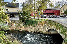 Stone arch bridge over the Paulins Kill
 -
 Lafayette Foundry information
 -
 Ludlum-Mabee House


Geography[edit]
According to the United States Census Bureau, the township had a total area of 17.97 square miles (46.54 km2), including 17.88 square miles (46.32 km2) of land and 0.09 square miles (0.23 km2) of water (0.48%).[1][2]
Unincorporated communities, localities and place names located partially or completely within the township include Branchville Junction, Harmonyvale, Hopkins Corner, Warbasse and Warbasse Junction.[28]
Lafayette Township borders the municipalities of Andover Township, Frankford Township, Hampton Township, Hardyston Township, Sparta Township and Wantage Township.[29][30]
Demographics[edit]
| Census | Pop. | Note | %± |
|---|---|---|---|
| 1850 | 928 | — | |
| 1860 | 919 | −1.0% | |
| 1870 | 884 | −3.8% | |
| 1880 | 781 | −11.7% | |
| 1890 | 742 | −5.0% | |
| 1900 | 717 | −3.4% | |
| 1910 | 683 | −4.7% | |
| 1920 | 634 | −7.2% | |
| 1930 | 735 | 15.9% | |
| 1940 | 803 | 9.3% | |
| 1950 | 836 | 4.1% | |
| 1960 | 1,100 | 31.6% | |
| 1970 | 1,202 | 9.3% | |
| 1980 | 1,614 | 34.3% | |
| 1990 | 1,902 | 17.8% | |
| 2000 | 2,300 | 20.9% | |
| 2010 | 2,538 | 10.3% | |
| 2020 | 2,358 | −7.1% | |
| 2022 (est.) | 2,385 | [9] | 1.1% |
| Population sources: 1850–1920[31] 1850–1870[32] 1850[33] 1870[34] 1880–1890[35] 1890–1910[36] 1910–1930[37] 1940–2000[38] 2000[39][40] 2010[17][18] 2020[8] | |||
2010 census[edit]
The 2010 United States census counted 2,538 people, 875 households, and 721 families in the township. The population density was 141.3 per square mile (54.6/km2). There were 919 housing units at an average density of 51.2 per square mile (19.8/km2). The racial makeup was 95.43% (2,422) White, 1.58% (40) Black or African American, 0.00% (0) Native American, 0.75% (19) Asian, 0.00% (0) Pacific Islander, 0.63% (16) from other races, and 1.62% (41) from two or more races. Hispanic or Latino of any race were 5.08% (129) of the population.[17]
Of the 875 households, 34.2% had children under the age of 18; 69.6% were married couples living together; 8.9% had a female householder with no husband present and 17.6% were non-families. Of all households, 13.1% were made up of individuals and 4.8% had someone living alone who was 65 years of age or older. The average household size was 2.85 and the average family size was 3.12.[17]
23.4% of the population were under the age of 18, 7.9% from 18 to 24, 20.8% from 25 to 44, 35.1% from 45 to 64, and 12.8% who were 65 years of age or older. The median age was 43.7 years. For every 100 females, the population had 95.4 males. For every 100 females ages 18 and older there were 97.5 males.[17]
The Census Bureau's 2006–2010 American Community Survey showed that (in 2010 inflation-adjusted dollars) median household income was $96,369 (with a margin of error of +/− $10,553) and the median family income was $98,750 (+/− $11,241). Males had a median income of $71,607 (+/− $22,034) versus $56,964 (+/− $13,270) for females. The per capita income for the borough was $34,364 (+/− $3,922). About 6.4% of families and 8.0% of the population were below the poverty line, including 12.7% of those under age 18 and none of those age 65 or over.[41]
2000 census[edit]
As of the 2000 United States census[14] there were 2,300 people, 771 households, and 647 families residing in the township. The population density was 127.6 inhabitants per square mile (49.3/km2). There were 799 housing units at an average density of 44.3 per square mile (17.1/km2). The racial makeup of the township was 97.04% White, 1.04% African American, 0.09% Native American, 0.78% Asian, 0.35% from other races, and 0.70% from two or more races. Hispanic or Latino of any race were 2.35% of the population.[39][40]
There were 771 households, out of which 38.1% had children under the age of 18 living with them, 73.4% were married couples living together, 7.5% had a female householder with no husband present, and 16.0% were non-families. 12.1% of all households were made up of individuals, and 3.6% had someone living alone who was 65 years of age or older. The average household size was 2.95 and the average family size was 3.20.[39][40]
In the township the population was spread out, with 27.4% under the age of 18, 5.3% from 18 to 24, 29.5% from 25 to 44, 28.6% from 45 to 64, and 9.3% who were 65 years of age or older. The median age was 39 years. For every 100 females, there were 100.7 males. For every 100 females age 18 and over, there were 97.7 males.[39][40]
The median income for a household in the township was $82,805, and the median income for a family was $87,650. Males had a median income of $61,307 versus $38,816 for females. The per capita income for the township was $30,491. About 1.2% of families and 3.7% of the population were below the poverty line, including 2.0% of those under age 18 and 2.3% of those age 65 or over.[39][40]
Government[edit]
Local government[edit]
Lafayette Township is governed under the Township form of New Jersey municipal government, one of 141 municipalities (of the 564) statewide that use this form, the second-most commonly used form of government in the state.[42] The Township Committee is comprised of five members, who are elected directly by the voters at-large in partisan elections to serve three-year terms of office on a staggered basis, with either one or two seats coming up for election each year as part of the November general election in a three-year cycle.[6][43] At an annual reorganization meeting, the Township Committee selects one of its members to serve as Mayor.
As of 2022[update], members of the Lafayette Township Committee are Mayor Kevin K. O'Leary (R, term on township committee ends December 31, 2024; term as mayor ends 2022), Deputy Mayor Richard Hughes (R, term on committee and as deputy mayor ends 2022), Richard Bruning (R, 2022), Gregory J. Corcoran (R, 2023) and Alan R. Henderson (R, 2023).[3][44][45][46][47]
Federal, state and county representation[edit]
Lafayette Township is located in the 5th Congressional District[48] and is part of New Jersey's 24th state legislative district.[49][50][51]
For the 118th United States Congress, New Jersey's 5th congressional district is represented by Josh Gottheimer (D, Wyckoff).[52][53] New Jersey is represented in the United States Senate by Democrats Cory Booker (Newark, term ends 2027)[54] and Bob Menendez (Englewood Cliffs, term ends 2025).[55][56]
For the 2024-2025 session, the 24th legislative district of the New Jersey Legislature is represented in the State Senate by Parker Space (R, Wantage Township) and in the General Assembly by Dawn Fantasia (R, Franklin) and Mike Inganamort (R, Chester Township).[57]
Sussex County is governed by a Board of County Commissioners whose five members are elected at-large in partisan elections on a staggered basis, with either one or two seats coming up for election each year. At an annual reorganization meeting held in the beginning of January, the board selects a Commissioner Director and Deputy Director from among its members, with day-to-day supervision of the operation of the county delegated to a County Administrator.[58] As of 2024[update], Sussex County's Commissioners are:
William Hayden (I, Branchville, 2025), Deputy Director Chris Carney (R, Frankford Township, 2024),[59] Earl Schick (R, Newton, 2024),[60] Director Jill Space (R, Wantage Township, 2025)[61] and Jack DeGroot (R, Sussex, 2026).[62][63]
Constitutional officers elected on a countywide basis are: Clerk Jeffrey M. Parrott (R, Wantage Township, 2026),[64] Sheriff Michael F. Strada (R, Hampton Township, 2025)[65] and Surrogate Gary R. Chiusano (R, Frankford Township, 2028).[66]
Politics[edit]
As of March 2011, there were a total of 1,738 registered voters in Lafayette Township, of which 228 (13.1% vs. 16.5% countywide) were registered as Democrats, 781 (44.9% vs. 39.3%) were registered as Republicans and 727 (41.8% vs. 44.1%) were registered as Unaffiliated. There were 2 voters registered as Libertarians or Greens.[67] Among the township's 2010 Census population, 68.5% (vs. 65.8% in Sussex County) were registered to vote, including 89.4% of those ages 18 and over (vs. 86.5% countywide).[67][68]
In the 2012 presidential election, Republican Mitt Romney received 867 votes (65.7% vs. 59.4% countywide), ahead of Democrat Barack Obama with 431 votes (32.7% vs. 38.2%) and other candidates with 18 votes (1.4% vs. 2.1%), among the 1,319 ballots cast by the township's 1,815 registered voters, for a turnout of 72.7% (vs. 68.3% in Sussex County).[69] In the 2008 presidential election, Republican John McCain received 921 votes (67.3% vs. 59.2% countywide), ahead of Democrat Barack Obama with 417 votes (30.5% vs. 38.7%) and other candidates with 18 votes (1.3% vs. 1.5%), among the 1,368 ballots cast by the township's 1,740 registered voters, for a turnout of 78.6% (vs. 76.9% in Sussex County).[70] In the 2004 presidential election, Republican George W. Bush received 883 votes (67.4% vs. 63.9% countywide), ahead of Democrat John Kerry with 404 votes (30.8% vs. 34.4%) and other candidates with 18 votes (1.4% vs. 1.3%), among the 1,311 ballots cast by the township's 1,583 registered voters, for a turnout of 82.8% (vs. 77.7% in the whole county).[71]
In the 2013 gubernatorial election, Republican Chris Christie received 76.5% of the vote (646 cast), ahead of Democrat Barbara Buono with 20.4% (172 votes), and other candidates with 3.1% (26 votes), among the 855 ballots cast by the township's 1,824 registered voters (11 ballots were spoiled), for a turnout of 46.9%.[72][73] In the 2009 gubernatorial election, Republican Chris Christie received 635 votes (66.2% vs. 63.3% countywide), ahead of Democrat Jon Corzine with 214 votes (22.3% vs. 25.7%), Independent Chris Daggett with 94 votes (9.8% vs. 9.1%) and other candidates with 14 votes (1.5% vs. 1.3%), among the 959 ballots cast by the township's 1,702 registered voters, yielding a 56.3% turnout (vs. 52.3% in the county).[74]
Education[edit]
Public school students in pre-kindergarten through eighth grade attend the Lafayette Township School District.[75][76] As of the 2022–23 school year, the district, comprised of one school, had an enrollment of 209 students and 23.9 classroom teachers (on an FTE basis), for a student–teacher ratio of 8.8:1.[77]
For ninth through twelfth grades, public school students attend High Point Regional High School, which also serves students from Branchville, Frankford Township, Montague Township, Sussex Borough and Wantage Township (where the school is located).[78][79][80] As of the 2022–23 school year, the high school had an enrollment of 817 students and 68.4 classroom teachers (on an FTE basis), for a student–teacher ratio of 11.9:1.[81] The district is governed by a nine-member board of education; seats on the board are allocated based on the population of the constituent municipalities, with one seat assigned to Lafayette Township.[82]
Transportation[edit]
_at_Morris_Farm_Road_in_Lafayette_Township,_Sussex_County,_New_Jersey.jpg)
As of May 2010[update], the township had a total of 46.27 miles (74.46 km) of roadways, of which 29.91 miles (48.14 km) were maintained by the municipality, 10.24 miles (16.48 km) by Sussex County and 6.12 miles (9.85 km) by the New Jersey Department of Transportation.[83]
The main highways serving Lafayette Township are New Jersey Route 15 and New Jersey Route 94. The two routes run concurrently in opposite directions for a short stretch in Lafayette Township.
Notable people[edit]
People who were born in, residents of, or otherwise closely associated with Lafayette Township include:
- Andy Albeck (1921–2010), movie executive who served as president and chief executive of United Artists and operated the award-winning Albeck Family Christmas Tree farm in Lafayette Township[84]
- Cleve Backster (1924–2013), interrogation specialist for the Central Intelligence Agency, best known for his 1960s experiments with plants using a polygraph which led to his theory of "primary perception" where he claimed that plants "feel pain" and have extrasensory perception[85]
- Bhikkhu Bodhi (born 1944), Theravada Buddhist monk, ordained in Sri Lanka, who was appointed the second president of the Buddhist Publication Society[86]
- Andrew J. Rogers (1828–1900), lawyer, teacher, clerk, police commissioner and Democratic Party politician who represented New Jersey's 4th congressional district in the United States House of Representatives from 1863 to 1867[87]
- Jay Nelson Tuck (1916–1985), journalist, television critic who served as president of The Newspaper Guild from 1950 to 1952[88]
References[edit]
- ^ a b c d e 2019 Census Gazetteer Files: New Jersey Places, United States Census Bureau. Accessed July 1, 2020.
- ^ a b US Gazetteer files: 2010, 2000, and 1990 , United States Census Bureau. Accessed September 4, 2014.
- ^ a b Township Committee, Lafayette Township. Accessed April 20, 2022. "Lafayette Township is governed by a Township Committee consisting of five elected members. The members serve staggered three-year terms. The Township Committee elects a Mayor who serves a one-year term. The Mayor serves as the Chair of the Committee and has powers vested in the mayor's office by general law."
- ^ 2023 New Jersey Mayors Directory, New Jersey Department of Community Affairs, updated February 8, 2023. Accessed February 10, 2023.
- ^ Administration, Lafayette Township. Accessed April 20, 2022.
- ^ a b 2012 New Jersey Legislative District Data Book, Rutgers University Edward J. Bloustein School of Planning and Public Policy, March 2013, p. 110.
- ^ U.S. Geological Survey Geographic Names Information System: Township of Lafayette, Geographic Names Information System. Accessed March 7, 2013.
- ^ a b c Total Population: Census 2010 - Census 2020 New Jersey Municipalities, New Jersey Department of Labor and Workforce Development. Accessed December 1, 2022.
- ^ a b Annual Estimates of the Resident Population for Minor Civil Divisions in New Jersey: April 1, 2020 to July 1, 2022, United States Census Bureau, released May 2023. Accessed May 18, 2023.
- ^ a b Population Density by County and Municipality: New Jersey, 2020 and 2021, New Jersey Department of Labor and Workforce Development. Accessed March 1, 2023.
- ^ Look Up a ZIP Code for Lafayette, NJ, United States Postal Service. Accessed February 21, 2013.
- ^ Zip Codes, State of New Jersey. Accessed September 14, 2013.
- ^ Area Code Lookup - NPA NXX for Sussex, NJ, Area-Codes.com. Accessed September 14, 2013.
- ^ a b U.S. Census website, United States Census Bureau. Accessed September 4, 2014.
- ^ Geographic Codes Lookup for New Jersey, Missouri Census Data Center. Accessed April 1, 2022.
- ^ US Board on Geographic Names, United States Geological Survey. Accessed September 4, 2014.
- ^ a b c d e DP-1 - Profile of General Population and Housing Characteristics: 2010 for Lafayette township, Sussex County, New Jersey Archived 2020-02-12 at archive.today, United States Census Bureau. Accessed February 21, 2013.
- ^ a b Profile of General Demographic Characteristics: 2010 for Lafayette township[permanent dead link], New Jersey Department of Labor and Workforce Development. Accessed February 21, 2013.
- ^ Table 7. Population for the Counties and Municipalities in New Jersey: 1990, 2000 and 2010, New Jersey Department of Labor and Workforce Development, February 2011. Accessed May 1, 2023.
- ^ Snyder, John P. The Story of New Jersey's Civil Boundaries: 1606-1968, Bureau of Geology and Topography; Trenton, New Jersey; 1969. p. 231. Accessed October 26, 2012.
- ^ History of Lafayette Township, NY-NJ-CT Botany Online. Accessed April 8, 2008.
- ^ Home Page, Lafayette Township. Accessed February 21, 2013. "Lafayette Township was incorporated in 1845 and is the first town in the United States to be named after the Marquis de LaFayette."
- ^ Hutchinson, Viola L. The Origin of New Jersey Place Names, New Jersey Public Library Commission, May 1945. Accessed September 2, 2015.
- ^ "National Register Information System – (#13001024)". National Register of Historic Places. National Park Service. November 2, 2013.
- ^ "New Jersey and National Registers of Historic Places - Sussex County" (PDF). New Jersey Department of Environmental Protection - Historic Preservation Office. September 28, 2021. p. 4.
- ^ a b Margulies, Michael; Carson, Chris (September 2013). "National Register of Historic Places Inventory/Nomination: Lafayette Village Historic District". National Park Service. With accompanying 45 photos.
- ^ "Welcome". Lafayette Center Preservation Foundation.
- ^ Locality Search, State of New Jersey. Accessed May 1, 2015.
- ^ Sussex County Map, Sussex County, New Jersey. Accessed February 25, 2020.
- ^ New Jersey Municipal Boundaries, New Jersey Department of Transportation. Accessed November 15, 2019.
- ^ Compendium of censuses 1726-1905: together with the tabulated returns of 1905, New Jersey Department of State, 1906. Accessed September 11, 2013.
- ^ Raum, John O. The History of New Jersey: From Its Earliest Settlement to the Present Time, Volume 1, p. 271, J. E. Potter and company, 1877. Accessed February 21, 2013. "Lafayette is the most central township in the county and contained in 1850, 928 inhabitants; in 1860, 919; and in 1870, 884."
- ^ Debow, James Dunwoody Brownson. The Seventh Census of the United States: 1850, p. 141. R. Armstrong, 1853. Accessed February 21, 2013.
- ^ Staff. A compendium of the ninth census, 1870, p. 260. United States Census Bureau, 1872. Accessed February 21, 2013.
- ^ Porter, Robert Percival. Preliminary Results as Contained in the Eleventh Census Bulletins: Volume III - 51 to 75, p. 97. United States Census Bureau, 1890. Accessed February 21, 2013.
- ^ Thirteenth Census of the United States, 1910: Population by Counties and Minor Civil Divisions, 1910, 1900, 1890, United States Census Bureau, p. 338. Accessed August 30, 2012.
- ^ Fifteenth Census of the United States : 1930 - Population Volume I, United States Census Bureau, p. 7194. Accessed February 21, 2013.
- ^ Table 6: New Jersey Resident Population by Municipality: 1940 - 2000, Workforce New Jersey Public Information Network, August 2001. Accessed May 1, 2023.
- ^ a b c d e Census 2000 Profiles of Demographic / Social / Economic / Housing Characteristics for Lafayette township, New Jersey Archived 2016-10-31 at the Wayback Machine, United States Census Bureau. Accessed October 31, 2016.
- ^ a b c d e DP-1: Profile of General Demographic Characteristics: 2000 - Census 2000 Summary File 1 (SF 1) 100-Percent Data for Lafayette township, Sussex County, New Jersey Archived 2020-02-12 at archive.today, United States Census Bureau. Accessed February 21, 2013.
- ^ DP03: Selected Economic Characteristics from the 2006-2010 American Community Survey 5-Year Estimates for Lafayette township, Sussex County, New Jersey Archived 2020-02-12 at archive.today, United States Census Bureau. Accessed January 1, 2013.
- ^ Inventory of Municipal Forms of Government in New Jersey, Rutgers University Center for Government Studies, July 1, 2011. Accessed June 1, 2023.
- ^ "Forms of Municipal Government in New Jersey", p. 7. Rutgers University Center for Government Studies. Accessed June 1, 2023.
- ^ 2022 Municipal Data Sheet, Lafayette Township. Accessed August 2, 2022.
- ^ Summary Results Report November 2, 2021 General Election Official Results, Sussex County, New Jersey, updated November 22, 2021. Accessed January 1, 2022.
- ^ Election Summary November 3, 2020 General Election Official Amended Results, Sussex County, New Jersey, updated December 10, 2020. Accessed January 1, 2021.
- ^ Sussex County, New Jersey General Election November 5, 2019, Official Results Summary Report, Sussex County, New Jersey, dated November 8, 2019. Accessed January 1, 2020.
- ^ Plan Components Report, New Jersey Redistricting Commission, December 23, 2011. Accessed February 1, 2020.
- ^ Municipalities Sorted by 2011-2020 Legislative District, New Jersey Department of State. Accessed February 1, 2020.
- ^ 2019 New Jersey Citizen's Guide to Government, New Jersey League of Women Voters. Accessed October 30, 2019.
- ^ Districts by Number for 2011-2020, New Jersey Legislature. Accessed January 6, 2013.
- ^ Directory of Representatives: New Jersey, United States House of Representatives. Accessed January 3, 2019.
- ^ Biography, Congressman Josh Gottheimer. Accessed January 3, 2019. "Josh now lives in Wyckoff, New Jersey with Marla, his wife who was a federal prosecutor, and their two young children, Ellie and Ben."
- ^ U.S. Sen. Cory Booker cruises past Republican challenger Rik Mehta in New Jersey, PhillyVoice. Accessed April 30, 2021. "He now owns a home and lives in Newark's Central Ward community."
- ^ Biography of Bob Menendez, United States Senate, January 26, 2015. "Menendez, who started his political career in Union City, moved in September from Paramus to one of Harrison's new apartment buildings near the town's PATH station.."
- ^ Home, sweet home: Bob Menendez back in Hudson County. nj.com. Accessed April 30, 2021. "Booker, Cory A. - (D - NJ) Class II; Menendez, Robert - (D - NJ) Class I"
- ^ Legislative Roster for District 24, New Jersey Legislature. Accessed January 18, 2024.
- ^ About County Government, Sussex County, New Jersey. Accessed May 1, 2022. "Sussex County is governed by five (5) Commissioners who are elected by the voters of Sussex County. Each serves on the county’s Board of County Commissioners for a term of three (3) years, after which time they can seek re‐election or retire.... The Commissioners are elected at‐large to serve three‐year staggered terms. The five Commissioners elect a director from among themselves to run their meetings and to serve as a spokesperson for the board."
- ^ Chris Carney, Sussex County, New Jersey. Accessed May 1, 2022.
- ^ Dawn Fantasia, Sussex County, New Jersey. Accessed May 1, 2022.
- ^ Jill Space, Sussex County, New Jersey. Accessed May 1, 2022.
- ^ Herbert Yardley, Sussex County, New Jersey. Accessed May 1, 2022.
- ^ Board of County Commissioners, Sussex County, New Jersey. Accessed May 1, 2022.
- ^ Contact Us, Sussex County Clerk. Accessed May 1, 2022.
- ^ Administration, Sussex County Sheriff's Office. Accessed May 1, 2022.
- ^ Home Page, Sussex County Surrogate. Accessed May 1, 2022.
- ^ a b Voter Registration Summary - Sussex, New Jersey Department of State Division of Elections, March 23, 2011. Accessed February 21, 2013.
- ^ GCT-P7: Selected Age Groups: 2010 - State -- County Subdivision; 2010 Census Summary File 1 for New Jersey Archived 2020-02-12 at archive.today, United States Census Bureau. Accessed February 21, 2013.
- ^ General Election November 6, 2012: District Report - Group Detail, Sussex County, New Jersey Clerk, run date November 30, 2012. Accessed May 10, 2017.
- ^ 2008 Presidential General Election Results: Sussex County, New Jersey Department of State Division of Elections, December 23, 2008. Accessed February 21, 2013.
- ^ 2004 Presidential Election: Sussex County, New Jersey Department of State Division of Elections, December 13, 2004. Accessed February 21, 2013.
- ^ "Governor - Sussex County" (PDF). New Jersey Department of Elections. January 29, 2014. Retrieved December 24, 2014.
- ^ "Number of Registered Voters and Ballots Cast - November 5, 2013 - General Election Results - Sussex County" (PDF). New Jersey Department of Elections. January 29, 2014. Retrieved December 24, 2014.
- ^ 2009 Governor: Sussex County Archived 2013-06-06 at the Wayback Machine, New Jersey Department of State Division of Elections, December 31, 2009. Accessed February 21, 2013.
- ^ District Bylaw 0110 - Identification, Lafayette Township School District. Accessed September 5, 2020. "Purpose: The Board of Education exists for the purpose of providing a thorough and efficient system of free public education in grades Pre-Kindergarten through eight in the Lafayette Township School District. Composition: The Lafayette Township School District is comprised of all the area within the municipal boundaries of Lafayette Township."
- ^ School Performance Reports for the Lafayette Township School District, New Jersey Department of Education. Accessed March 7, 2024.
- ^ District information for Lafayette Township School District, National Center for Education Statistics. Accessed February 1, 2024.
- ^ High Point Regional Board of Education Bylaw 0110 - Name and Classification, High Point Regional High School. Accessed March 7, 2024. "Composition -The High Point Regional High School District shall comprise all the area within the municipal boundaries of Branchville, Frankford, Lafayette, Sussex and Wantage for the purpose of providing a program of education in grades 9 through 12."
- ^ High Point Regional High School 2015 Report Card Narrative, New Jersey Department of Education. Accessed March 31, 2020. "High Point Regional High School is a comprehensive high school serving the diversified needs of the three surrounding K through 8 school districts of Lafayette, Frankford, Montague, and Sussex-Wantage."
- ^ "2022-23 School Profile", High Point Regional High School. Accessed March 7, 2024. "Located 63 miles northwest of Manhattan in bucolic Sussex County NJ, High Point serves students from six municipalities: Branchville, Lafayette, Frankford, Montague, Sussex, and Wantage."
- ^ School data for High Point Regional High School District, National Center for Education Statistics. Accessed February 1, 2024.
- ^ High Point Regional Board of Education Bylaw 0141 - Board Member Number and Term, High Point Regional High School. Accessed March 31, 2020. "The Board of Education shall consist of nine members, proportioned as follows: Wantage - four; Frankford - two; Sussex - one; Lafayette - one; Branchville - one. The term of a Board member shall be three years."
- ^ Sussex County Mileage by Municipality and Jurisdiction, New Jersey Department of Transportation, May 2010. Accessed July 24, 2014.
- ^ Staff. "Former United Artists head Andy Albeck dies at 89", Reuters, October 3, 2010. Accessed May 1, 2015. "Albeck left UA in 1981 and, with his wife, Lotte, nurtured his passion for the outdoors as a Christmas tree farmer on 200 acres in Lafayette, N.J. The Albeck Family Christmas Tree farm won four grand championship titles at the Flemington Fair for their blue spruce trees from 1984-87."
- ^ Matté, James Allen. Forensic Psychophysiology Using the Polygraph: Scientific Truth Verification, p. 39. J.A.M. Publications, 1996. ISBN 9780965579407. "Cleve Backster, born Grover Cleveland Backster Jr., on 27 February 1924 at Lafayette, New Jersey, received an appointment on 12 April 1948 as Plans Officer at the newly formed Central Intelligence Agency (CIA) whose near total operation was headquartered at 2430 E. Street, N. W. in Washington D. C...."
- ^ McLeod, Melvin, ed. The Best Buddhist Writing 2008, p. 333. Shambhala Publications, 2008. ISBN 9781590306154. Accessed May 10, 2017. "Bhikkhu Bodhi, an American Buddhist monk, was ordained in Sri Lanka in 1972.... He currently lives at Bodhi Monastery in Lafayette, New Jersey."
- ^ Rogers, Andrew Jackson, (1828 - 1900), Biographical Directory of the United States Congress. Accessed May 1, 2015.
- ^ Staff. "Jay Nelson Tuck, 69, A Reporter and Editor", The New York Times, November 25, 1985. Accessed May 1, 2015. "Jay Nelson Tuck, a journalist and former president of the Newspaper Guild of New York, died of lung cancer Friday at his home in Lafayette, N.J."
Further reading[edit]
- McCabe, Wayne T.; and Gordon, Kate. A Penny A View...An Album of Postcard Views...Lafayette, N.J. (Newton, NJ: Historic Preservation Alternatives, 1993).
External links[edit]
- Lafayette Township Official Website
- Sussex County webpage for Lafayette Township
- Lafayette Township School District
- School Performance Reports for the Lafayette Township School District, New Jersey Department of Education
- School Data for the Lafayette Township School District, National Center for Education Statistics
- High Point Regional High School
- Sensations Magazine – Three-time winner, national American Literary Magazine Awards, now based in and hosting events in Lafayette, NJ
- "The Lafayette Foundry". The Historical Marker Database.
Municipalities and communities of Sussex County, New Jersey, United States | ||
|---|---|---|
| Boroughs |  | |
| Town | ||
| Townships | ||
| CDPs | ||
| Other communities | ||
| Footnotes | ‡This populated place also has portions in an adjacent county or counties | |