
Lake Akan
| Lake Akan | |
|---|---|
| 阿寒湖 (Japanese) | |
 The view from Mount Oakan (July 2008) | |
 Lake Akan | |
| Location | Kushiro, Hokkaidō, Japan |
| Coordinates | 43°27′6″N 144°5′55″E / 43.45167°N 144.09861°E |
| Lake type | Dimictic |
| Primary outflows | Akan River |
| Catchment area | 148 km2 (57 sq mi) |
| Basin countries | Japan |
| Surface area | 13 km2 (3,200 acres) |
| Average depth | 17.8 m (58 ft) |
| Max. depth | 44.8 m (147 ft) |
| Water volume | 0.23 km3 (0.055 cu mi) |
| Shore length1 | 25.9 km (16.1 mi) |
| Surface elevation | 420 m (1,380 ft) |
| Frozen | December to April |
| Islands | 4: Ōjima, Kojima, Yaitai Island, Chūrui Island |
| Settlements | Kushiro |
| Official name | Akan-ko |
| Designated | 8 November 2005 |
| Reference no. | 1540[1] |
| 1 Shore length is not a well-defined measure. | |
Lake Akan (阿寒湖, Akan-ko) is a lake in Kushiro, Hokkaidō, Japan. It is located in Akan National Park and is a Ramsar Site.[2][3]
History[edit]
Volcanic activity formed the lake some 6,000 years ago, when a lava dam was formed. The lake used to have a clarity of 8–9 meters in the 1930s. Pollution from local hotspring resorts has decreased the transparency to 3–4 meters.[4]
Flora and fauna[edit]
The lake is famous for the marimo (Aegagropila linnaei), aggregations of algae that form into spherical shapes 2–30 cm in diameter. Other flora of the lake include the following:[4]
- Phragmites communis
- Nuphar sp.
- Potamogeton crispus
- Hydrilla verticillata
- Myriophyllum verticillatum
- Vallisneria gigantea
- Melosira italica
- Asterionella formosa
- Synedra
Kokanee salmon (Oncorhynchus nerka) are native to Lake Akan. Other fauna of the lake include the following:[4]
- Zooplankton:
- Bottom:
- Fish:
Climate[edit]
| Climate data for Lake Akan (1991−2020 normals, extremes 1977−present) | |||||||||||||
|---|---|---|---|---|---|---|---|---|---|---|---|---|---|
| Month | Jan | Feb | Mar | Apr | May | Jun | Jul | Aug | Sep | Oct | Nov | Dec | Year |
| Record high °C (°F) | 6.1 (43.0) |
10.8 (51.4) |
16.5 (61.7) |
28.3 (82.9) |
35.5 (95.9) |
34.5 (94.1) |
34.9 (94.8) |
33.9 (93.0) |
31.4 (88.5) |
24.5 (76.1) |
19.0 (66.2) |
11.8 (53.2) |
35.5 (95.9) |
| Mean daily maximum °C (°F) | −4.2 (24.4) |
−3.1 (26.4) |
1.4 (34.5) |
8.1 (46.6) |
15.1 (59.2) |
18.9 (66.0) |
22.3 (72.1) |
22.8 (73.0) |
19.0 (66.2) |
13.2 (55.8) |
5.8 (42.4) |
−1.4 (29.5) |
9.8 (49.7) |
| Daily mean °C (°F) | −10.0 (14.0) |
−9.4 (15.1) |
−4.2 (24.4) |
2.3 (36.1) |
8.5 (47.3) |
13.1 (55.6) |
17.1 (62.8) |
18.0 (64.4) |
14.0 (57.2) |
7.5 (45.5) |
0.7 (33.3) |
−6.5 (20.3) |
4.3 (39.7) |
| Mean daily minimum °C (°F) | −16.7 (1.9) |
−16.8 (1.8) |
−10.8 (12.6) |
−3.3 (26.1) |
2.3 (36.1) |
8.0 (46.4) |
12.9 (55.2) |
13.9 (57.0) |
9.3 (48.7) |
2.1 (35.8) |
−4.3 (24.3) |
−12.1 (10.2) |
−1.3 (29.7) |
| Record low °C (°F) | −30.2 (−22.4) |
−30.7 (−23.3) |
−26.6 (−15.9) |
−20.9 (−5.6) |
−7.5 (18.5) |
−3.3 (26.1) |
1.8 (35.2) |
3.2 (37.8) |
−1.2 (29.8) |
−7.6 (18.3) |
−17.3 (0.9) |
−26.9 (−16.4) |
−30.7 (−23.3) |
| Average precipitation mm (inches) | 63.2 (2.49) |
44.5 (1.75) |
70.2 (2.76) |
90.8 (3.57) |
105.7 (4.16) |
84.4 (3.32) |
103.2 (4.06) |
160.0 (6.30) |
165.7 (6.52) |
137.8 (5.43) |
85.2 (3.35) |
87.4 (3.44) |
1,197.9 (47.16) |
| Average snowfall cm (inches) | 132 (52) |
96 (38) |
105 (41) |
54 (21) |
3 (1.2) |
0 (0) |
0 (0) |
0 (0) |
0 (0) |
1 (0.4) |
31 (12) |
123 (48) |
548 (216) |
| Average precipitation days (≥ 1.0 mm) | 10.2 | 8.9 | 11.5 | 11.3 | 11.0 | 10.1 | 10.4 | 11.4 | 12.0 | 10.5 | 9.8 | 9.8 | 126.9 |
| Average snowy days (≥ 3 cm) | 12.3 | 10.4 | 12.1 | 7.0 | 0.4 | 0 | 0 | 0 | 0 | 0.1 | 3.9 | 13.0 | 59.2 |
| Mean monthly sunshine hours | 97.5 | 111.9 | 137.1 | 154.0 | 169.4 | 146.3 | 132.2 | 115.7 | 110.1 | 123.3 | 110.6 | 107.3 | 1,546 |
| Source: Japan Meteorological Agency[5][6] | |||||||||||||
Gallery[edit]
-

-
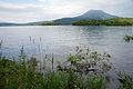 Lake Akan and Mount Oakan
 -
A few scenes in 2021


See also[edit]
- List of Special Places of Scenic Beauty, Special Historic Sites and Special Natural Monuments
- Ramsar sites in Japan
References[edit]
- ^ "Akan-ko". Ramsar Sites Information Service. Retrieved 25 April 2018.
- ^ "Data Summary: Akan-ko (Lake Akan)". World Lakes Database. International Lake Environment Committee. Archived from the original on 2012-04-20. Retrieved 2009-05-18.
- ^ "Ramsar Sites in Japan - Akan-ko" (PDF). Ministry of the Environment. Retrieved 24 March 2011.
- ^ a b c "AKAN-KO (LAKE AKAN)". World Lakes Database. International Lake Environment Committee. Archived from the original on 2012-03-05. Retrieved 2009-05-18.
- ^ 観測史上1~10位の値(年間を通じての値). JMA. Retrieved March 3, 2022.
- ^ 気象庁 / 平年値(年・月ごとの値). JMA. Retrieved March 3, 2022.
Wikimedia Commons has media related to Lake Akan.
| International | |
|---|---|
| National | |