
Saveh
Saveh
Persian: ساوه | |
|---|---|
City | |
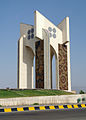
 Shahrdari Square in Saveh | |
 Saveh | |
| Coordinates: 35°01′40″N 50°21′40″E / 35.02778°N 50.36111°E[1] | |
| Country | Iran |
| Province | Markazi |
| County | Saveh |
| District | Central |
| Elevation | 1,008 m (3,307 ft) |
| Population (2016)[2] | |
| • Total | 220,762 |
| Time zone | UTC+3:30 (IRST) |
| Website | www www |
Saveh (Persian: ساوه), also Romanized as Sāveh and Sāwa,[3] is a city in the Central District of Saveh County, Markazi province, Iran, serving as capital of both the county and the district.[4] It is about 100 km (60 mi) southwest of Tehran.[5][6]
At the 2006 National Census, its population was 179,009 in 48,221 households.[7] The following census in 2011 counted 200,481 people in 58,255 households.[8] The latest census in 2016 showed a population of 220,762 people in 67,230 households.[2]
History[edit]
In the 7th century BC it was a stronghold of the Medes. During the Parthian rule of Persia, it was called Saavakineh, and was one of the main hubs of the empire.
In the 11th century, it was a residence of the Daylamites and of the Seljuks. It was severely damaged by the Mongol invasion in the 13th century; it was restored during the Ilkhanids. Saveh was again sacked by the Timurids, but later grew under the Safavids. In the summer of 1725 the city was besieged and captured by the Afghans after a battle with Tahmasp Mirza.[9] It eventually lost much of its importance when Tehran became the official capital of Persia and, in the mid-19th century, many of the inhabitants moved to Tehran.
Climate[edit]
Saveh has a hot semi-arid climate, (BSh) in Köppen climate classification and (BS) in Trewartha climate classification.[10] Its summers are very hot and dry, while its winters are cool to cold and somewhat rainy.
| Climate data for Saveh, altitude: 1108.0 m, from 1992–2005. | |||||||||||||
|---|---|---|---|---|---|---|---|---|---|---|---|---|---|
| Month | Jan | Feb | Mar | Apr | May | Jun | Jul | Aug | Sep | Oct | Nov | Dec | Year |
| Record high °C (°F) | 19.6 (67.3) |
23.6 (74.5) |
29.0 (84.2) |
33.6 (92.5) |
39.8 (103.6) |
42.0 (107.6) |
43.8 (110.8) |
43.0 (109.4) |
39.6 (103.3) |
34.6 (94.3) |
28.0 (82.4) |
23.6 (74.5) |
43.8 (110.8) |
| Mean daily maximum °C (°F) | 9.6 (49.3) |
12.5 (54.5) |
17.1 (62.8) |
23.7 (74.7) |
29.3 (84.7) |
35.2 (95.4) |
37.7 (99.9) |
37.2 (99.0) |
33.0 (91.4) |
26.1 (79.0) |
17.1 (62.8) |
11.0 (51.8) |
24.1 (75.4) |
| Daily mean °C (°F) | 4.8 (40.6) |
7.0 (44.6) |
11.4 (52.5) |
17.7 (63.9) |
22.9 (73.2) |
28.5 (83.3) |
31.4 (88.5) |
30.8 (87.4) |
26.2 (79.2) |
19.8 (67.6) |
11.7 (53.1) |
6.5 (43.7) |
18.2 (64.8) |
| Mean daily minimum °C (°F) | 0.1 (32.2) |
1.5 (34.7) |
5.8 (42.4) |
11.7 (53.1) |
16.4 (61.5) |
21.8 (71.2) |
25.1 (77.2) |
24.4 (75.9) |
19.4 (66.9) |
13.4 (56.1) |
6.4 (43.5) |
2.0 (35.6) |
12.3 (54.2) |
| Record low °C (°F) | −11.0 (12.2) |
−14.4 (6.1) |
−4.6 (23.7) |
0.8 (33.4) |
6.8 (44.2) |
13.0 (55.4) |
17.6 (63.7) |
16.6 (61.9) |
11.2 (52.2) |
5.6 (42.1) |
−7.2 (19.0) |
−6.5 (20.3) |
−14.4 (6.1) |
| Average precipitation mm (inches) | 36.2 (1.43) |
23.1 (0.91) |
34.1 (1.34) |
28.0 (1.10) |
14.5 (0.57) |
1.4 (0.06) |
1.3 (0.05) |
0.2 (0.01) |
0.4 (0.02) |
6.0 (0.24) |
28.0 (1.10) |
33.1 (1.30) |
206.3 (8.13) |
| Average precipitation days | 7.5 | 5.8 | 7.3 | 7.5 | 6.2 | 1.2 | 0.9 | 0.3 | 0.5 | 2.3 | 5.9 | 6.9 | 52.3 |
| Source: [11] | |||||||||||||
Main sights[edit]
- Jameh Mosque of Saveh, built by the Seljuks during the 11th century. It includes a courtyard, porch, a 14 m tall minaret, nocturnal areas, a tiled dome (14 m tall, with a diameter of 16 m) and two altars with inscription in Kufic script.
- Red Mosque of Saveh, also known as Enqelab Mosque. Dating to the Seljuk-era, it has a brickwork dome, an 11th-century minaret, three porticoes, and internally houses an altar with plasterwork and inscriptions.
- Imamzadeh Soltan Seyed Eshaq Mausoleum
- Sorkhdeh Bridge, south of the city
- Khamseh-Abad caravansarai
Outside the city are the fortresses of Esmaeilieh (35 km), Alvir and Ardemin (56 km, on the road to Hamadan), as well as the archaeological sites of Aveh and Alishar.
Economy[edit]
Saveh produces large amounts of wheat and cotton. It is also well known for its pomegranates and melons.[12] Kaveh Industrial City, the largest industrial city in Iran, is located in Saveh.
Legends[edit]
According to Iranian tradition, the Magi who visited the infant Jesus traveled from Saveh, and are buried among its ruins. Marco Polo described the tombs of the Magi in his travel book, Il Milione:
In Persia is the city of Saba, from which the Three Magi set out... and in this city they are buried, in three very large and beautiful monuments, side by side. And above them there is a square building, beautifully kept. The bodies are still entire, with hair and beard remaining. (Book i).[13]
Saveh is said to have possessed one of the greatest libraries in the Middle East, until its destruction by the Mongols during their first invasion of Iran.[13]
Another legend about Saveh is the Lake of Saveh. It is a lake which is said to have been located near the city. According to the legend mentioned in historical Persian texts, this lake dried out on the night of the birth of Muhammad. A recent investigation in the Zarand area between Tehran and Saveh has revealed some evidence of the existence of this lake in Zarand Plain.[14]
Politics[edit]
In 2004, Saveh became only the second city in the history of the Islamic Republic to appoint a woman as mayor.[6]
Notable people[edit]
- Yusuf Adil Shah (former Mamluk and founder of the Bijapur Sultanate)
Gallery[edit]
-
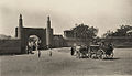 Saveh Gate, 1920s
 -
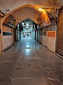 Saveh Bazaar
 -

-
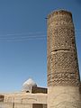 Minaret of Jameh Mosque of Saveh
 -
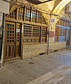 Saveh Bazaar Mosque
 -
 Sardaran square


References[edit]
- ^ OpenStreetMap contributors (1 September 2023). "Saveh, Saveh County" (Map). OpenStreetMap. Retrieved 1 September 2023.
- ^ a b "Census of the Islamic Republic of Iran, 1395 (2016)". AMAR (in Persian). The Statistical Center of Iran. p. 00. Archived from the original (Excel) on 17 October 2020. Retrieved 19 December 2022.
- ^ Saveh can be found at GEOnet Names Server, at this link, by opening the Advanced Search box, entering "-3083174" in the "Unique Feature Id" form, and clicking on "Search Database".
- ^ Habibi, Hassan (21 June 1369). "Approval of the organization and chain of citizenship of the elements and units of Markazi province's divisions to the citizenship of Arak city". Lamtakam (in Persian). Ministry of Interior, Political Commission of Defense of the Government Board. Archived from the original on 18 January 2024. Retrieved 18 January 2024.
- ^ "Savah". 1911 Encyclopædia Britannica.
- ^ a b "Iran's only female mayor sweeps up small town". The Daily Star. 4 August 2004.
- ^ "Census of the Islamic Republic of Iran, 1385 (2006)". AMAR (in Persian). The Statistical Center of Iran. p. 00. Archived from the original (Excel) on 20 September 2011. Retrieved 25 September 2022.
- ^ "Census of the Islamic Republic of Iran, 1390 (2011)". Syracuse University (in Persian). The Statistical Center of Iran. p. 00. Archived from the original (Excel) on 19 January 2023. Retrieved 19 December 2022.
- ^ Floor, Willem M. (1998). The Afghan Occupation of Safavid Persia, 1721-1729. Peeters Publishers & Booksellers. ISBN 2910640051.
- ^ "Climate: Saveh - Climate graph, Temperature graph, Climate table". IRIMO.IR. Retrieved 30 August 2013.
- ^ I.R. OF IRAN SHAHREKORD METEOROLOGICAL ORGANIZATION (IN PERSIAN) Archived 2017-08-29 at the Wayback Machine. 1992–2005
- ^ Cohen, Saul (1998). The Columbia Gazetteer of the World. Columbia University Press. p. 2833. ISBN 9780231110402.
- ^ a b Polo, Marco and Rustichello da Pisa (1903). Henry Yule and Henri Cordier (ed.). The Travels of Marco Polo: The Complete Yule-Cordier Edition.
- ^ Okhravi, R. and Djamali, M. (2003). "The missing ancient lake of Saveh: a historical review". Iranica Antiqua, 38, 327-344.
External links[edit]
Markazi Province, Iran | |||||||||||||||||||||||||
|---|---|---|---|---|---|---|---|---|---|---|---|---|---|---|---|---|---|---|---|---|---|---|---|---|---|
| Capital |  | ||||||||||||||||||||||||
| Counties and cities |
| ||||||||||||||||||||||||
| Sights |
| ||||||||||||||||||||||||
| populated places | |||||||||||||||||||||||||