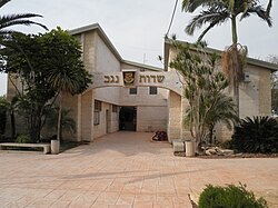
Sdot Negev Regional Council
Sdot Negev Regional Council
מועצה אזורית שדות נגב مجلس إقليمي سدوت نقب | |
|---|---|
 | |
 | |
| District | Southern |
| Established | 1951 |
| Government | |
| • Head of Municipality | Tamir Idan |
| Area | |
| • Total | 117,350 dunams (117.35 km2 or 45.31 sq mi) |
| Population (2014) | |
| • Total | 9,100 |
| • Density | 78/km2 (200/sq mi) |
| Website | Official website |

Sdot Negev Regional Council (Hebrew: מועצה אזורית שדות נגב, Mo'atza Azorit Sdot Negev, lit. Negev Fields Regional Council), formerly Azata Regional Council (Hebrew: מועצה אזורית עזתה, Mo'atza Azorit Azata) is a regional council in the northwestern Negev desert in the Southern District of Israel.
History[edit]
The Sdot Negev region council was established in 1951 by the Religious Zionist HaPoel HaMizrahi settlement movement. The council encompasses 16 communities: two kibbutzim, 12 moshavim and two community settlements.[1]
Despite frequent rocket attacks from the nearby Gaza Strip, the population of the Sdot Negev region has increased 55 percent in 2006–2012.[1] Residents have cited the educational system, atmosphere and rural lifestyle as incentives for moving to this part of the Negev.[1]
List of communities[edit]
Kibbutzim:
Moshavim:
- Beit HaGadi
- Givolim
- Kfar Maimon
- Mlilot
- Sharsheret
- Shibolim
- Shokeda
- Shuva
- Tkuma
- Yoshivia
- Zru'a
- Zimrat
Community settlements:
References[edit]
External links[edit]
- Official website (in Hebrew)

