
Wadi Qor
Wadi Qor
وادي قور | |
|---|---|
 Wadi Qor | |
| Coordinates: 24°54′41″N 56°5′55″E / 24.91139°N 56.09861°E | |
| Country | United Arab Emirates |
| Emirate | Ras Al Khaimah |
| Elevation | 401 m (1,318 ft) |
Wadi Qor (Arabic: وادي قور) is a seasonal watercourse in the Hajar Mountains of Ras Al Khaimah, in the United Arab Emirates. The wadi runs from the mountain village of Al Qor, near the Dubai exclave of Hatta, through the villages of Huwaylat, Rafaq and Al Nasla before crossing the Omani border and fanning out to the Batinah plain and the Gulf of Oman north of the Omani coastal village of Bu Baqarah.[1]
Traditionally a major trade route, the Wadi Qor forms one of the oldest caravan routes from the interior of the Gulf to the Batinah Coast. Its importance as a passage through the Hajar Mountains was eclipsed by the construction of the metalled road from Hatta to the Batinah coast.[2]
Extent[edit]
The wadi contains a number of Umm Al Nar era gravesites[3] and has been a rich source of archaeological finds.[4] Like many of the Hajar Mountain wadis, it is prone to heavy flooding.[5] A number of the communities throughout the wadi are increasingly deserted by young people moving to the UAE's cities, and seasonal occupation of houses is common, for instance during the Eid celebrations, when family members return to the villages.[6] The villages along the Wadi Qor were traditionally settled by members of the Dahaminah, Washahat and Bani Kaab tribes,[7][1] as well as some Maharzah.[8]
There is an Iron Age fort in the village of Rafaq.[9] An Islamic era fort in the village of Al Nasla has been restored.[10] A series of watchtowers dot the sides of the wadi along its course.
Waterways[edit]
The Wadi Qor also features a number of aflaj daudi, underground waterways or falaj, dug to distribute water for irrigation to fields from a mother spring or aquifer. The falaj daudi is distinguished from the falaj ghayli - open surface water channels and irrigation systems, or aflaj.[8]
-
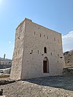 Al Nasla Fort in the Wadi Qor is an Islamic era fort, likely constructed in the 19th century.
 -
 The Wadi Qor facing north at Huwailat
 -
 The Wadi Qor at Al Nasla, looking north
 -
 One of a series of (mostly dilapidated) watchtowers overlooking the Wadi Qor


See also[edit]
References[edit]
- ^ a b Lorimer, John (1915). Gazetteer of the Persian Gulf. British Government, Bombay. p. 1560.
- ^ Zandi, Dariush (1991). Off-road in the Emirates. Dubai, U.A.E.: Motivate Publishing. p. 50. ISBN 1-873544-20-0. OCLC 39101747.
- ^ "Umm an Nar tombs in Wadi Qor". www.enhg.org. Retrieved 2018-09-16.
- ^ Phillips, C. S. (1997). "The pattern of settlement in the Wadi al-Qawr". Proceedings of the Seminar for Arabian Studies. 27: 205–218. JSTOR 41223600.
- ^ "Sharjah Police rescue 30 families as rains flood homes". The National. Retrieved 2018-09-16.
- ^ "Mosque in Wadi Qor set for busy Eid". The National. Retrieved 2018-09-12.
- ^ Heard-Bey, Frauke (2005). From Trucial States to United Arab Emirates : a society in transition. London: Motivate. p. 435. ISBN 1860631673. OCLC 64689681.
- ^ a b Lancaster, William, 1938- (2011). Honour is in contentment : life before oil in Ras al-Khaimah (UAE) and some neighbouring regions. Lancaster, Fidelity. Berlin: De Gruyter. p. 191. ISBN 978-3-11-022340-8. OCLC 763160662.
{{cite book}}: CS1 maint: multiple names: authors list (link) CS1 maint: numeric names: authors list (link) - ^ United Arab Emirates : a new perspective. Abed, Ibrahim., Hellyer, Peter. London: Trident Press. 2001. pp. 49. ISBN 1900724472. OCLC 47140175.
{{cite book}}: CS1 maint: others (link) - ^ "Historical Places". mun.rak.ae. Retrieved 2020-10-18.
| Cities |  | |
|---|---|---|
| Settlements | ||
| Mountains | ||
These prefixes ignored in the alphabetical ordering: Al, Al-Bu, Albu, Banu. | |
| Tribal coalition | |
Part of Arab tribes | |