
Wiesbaden
Wiesbaden | |
|---|---|
 Flag  Coat of arms | |
Location of Wiesbaden within Hessen  | |
 Wiesbaden  Wiesbaden | |
| Coordinates: 50°04′57″N 08°14′24″E / 50.08250°N 8.24000°E | |
| Country | Germany |
| State | Hesse |
| Admin. region | Darmstadt |
| District | Urban district |
| Founded | 121 |
| Subdivisions | 26 boroughs |
| Government | |
| • Lord mayor (2019–25) | Gert-Uwe Mende[1] (SPD) |
| • Governing parties | CDU / SPD |
| Area | |
| • Total | 203.9 km2 (78.7 sq mi) |
| Elevation | 115 m (377 ft) |
| Population (2022-12-31)[2] | |
| • Total | 283,083 |
| • Density | 1,400/km2 (3,600/sq mi) |
| Time zone | UTC+01:00 (CET) |
| • Summer (DST) | UTC+02:00 (CEST) |
| Postal codes | 65183–65207 55246 (Mainz-Kostheim) 55252 (Mainz-Kastel) |
| Dialling codes | 0611, 06122, 06127, 06134 |
| Vehicle registration | WI |
| Website | wiesbaden.de |


.jpg)


Wiesbaden (German pronunciation: [ˈviːsˌbaːdn̩] ⓘ; lit. 'meadow baths') is the capital of the German state of Hesse, and the second-largest Hessian city after Frankfurt am Main. With around 283,000 inhabitants, it is Germany's 24th-largest city. Wiesbaden forms a conurbation with a population of around 500,000 with the neighbouring city of Mainz. This conurbation is in turn embedded in the Rhine-Main Metropolitan Region—Germany's second-largest metropolitan region after Rhine-Ruhr—which also includes the nearby cities of Frankfurt am Main, Darmstadt, Offenbach am Main, and Hanau, and has a combined population exceeding 5.8 million.
The city is located on the Rhine, at the foothills of the Taunus, opposite the Rhineland-Palatine capital of Mainz, and the city centre is located in the wide valley of the small Salzbach stream. Wiesbaden lies in the Rheingau wine-growing region, one of Germany's 13 wine regions. Three of Wiesbaden's boroughs were part of the city of Mainz until 1945, and still bear the designation "Mainz" in their names—the so-called AKK-boroughs of Mainz-Amöneburg, Mainz-Kastel, and Mainz-Kostheim. This so-called AKK-Konflikt (de:AKK-Konflikt) is the main cause for the rivalry between Mainz and Wiesbaden. Wiesbaden Main Station is connected to Frankfurt am Main by the Rhine-Main S-Bahn rapid transit system.
Historically, Wiesbaden was a Nassauian city. From 1170 to 1629, it lay in the County of Nassau, and from 1629 to 1721, it was in the county and later principality of Nassau-Idstein, all of which were territories within the Holy Roman Empire ruled by branches of the House of Nassau. In 1728, the city found itself in the principality of Nassau-Usingen, and in 1744, Biebrich Palace became the main residence of the House of Nassau-Usingen. In 1806, the city became the capital of the Duchy of Nassau. Since 1841, the newly built Wiesbaden City Palace was the principal Nassauian residence. From 1868 to 1944, the city lay in the Prussian Province of Hesse-Nassau, and from 1944 to 1945, it was the capital of the Province of Nassau. In 1945, it became the capital of Greater Hesse and subsequently, in 1946, of Hesse.
Wiesbaden is one of the oldest spa towns in Europe. Its name translates to "meadow baths", and there are 15 mineral springs—14 of which are hot springs—in the city centre.[3] With a yield of around 2 million liters daily, Wiesbaden is the second-most productive German spa after Aachen. Its location in a mountain basin at the southern foot of the Taunus, protected by the mountains in the north and west, gives Wiesbaden a mild climate. It has been called the "Nice of the North" because of its climate and architecture.[4] The city of Wiesbaden is one of the wealthiest cities in Germany and one of those with above-average purchasing power.[5] The United States Army Europe and Africa headquarters are located in Wiesbaden-Erbenheim.
Geographical setting[edit]
Wiesbaden is situated on the right (northern) bank of the Rhine, above the confluence of the Main, where the Rhine's main direction changes from north to west. The city is across the Rhine from Mainz, the capital of the state of Rhineland-Palatinate. Frankfurt am Main is located about 38 kilometres (23.6 mi) east. To the north of the city are the Taunus Mountains, which trend in a northeasterly direction.
The city center, the Stadtmitte, is located in the north-easternmost part of the Upper Rhine Valley at the spurs of the Taunus mountains, about 5 kilometres (3.1 mi) from the Rhine. The landscape is formed by a wide lowland between the Taunus heights in the north, the Bierstadter Höhe and the Hainerberg in the east, the Mosbacher Mountain in the south, and the Schiersteiner Mountain in the west, an offshoot of the Taunus range.
The downtown is drained only by the narrow valley of the Salzbach, a tributary of the Rhine, on the eastern flanks of the Mosbacher Mountain. The city's main railway line and the Mainz road (Mainzer Straße) follow this valley. Several other streams drain into the Salzbach within the city center: the Wellritzbach, the Kesselbach, the Schwarzbach, the Dambach, and the Tennelbach, as well as the outflow of many thermal and mineral springs in the Kurhaus (spa) district. Above the city center, the Salzbach is better known as the Rambach.
The highest point of the Wiesbaden municipality is located northwest of the city center near the summit of the Hohe Wurzel, with an elevation of 608 metres (1,995 ft) above sea level. The lowest point is the harbour entrance of Schierstein at 83 metres (272 ft) above sea level. The central square (the Schlossplatz, or palace square) is at an elevation of 115 metres (377 ft).
Wiesbaden covers an area of 204 km2 (79 sq mi). It is 17.6 kilometres (10.9 mi) from north to south and 19.7 kilometres (12.2 mi) from west to east. In the north are vast forest areas, which cover 27.4% of the urban area. In the west and east are vineyards and agricultural land, which cover 31.1% of the area. Of the municipality's 79 kilometres (49.1 mi)-long border, the Rhine makes up 10.3 kilometres (6.4 mi).
Climate[edit]
Wiesbaden has a temperate-oceanic climate (Köppen: Cfb) with relatively cold winters and warm summers. Its average annual temperature is 9.8 °C (49.6 °F), with monthly mean temperatures ranging from 1.0 °C (33.8 °F) in January to 18.6 °C (65.5 °F) in July.
| Climate data for Wiesbaden | |||||||||||||
|---|---|---|---|---|---|---|---|---|---|---|---|---|---|
| Month | Jan | Feb | Mar | Apr | May | Jun | Jul | Aug | Sep | Oct | Nov | Dec | Year |
| Mean daily maximum °C (°F) | 4 (39) |
6 (43) |
11 (52) |
15 (59) |
20 (68) |
23 (73) |
25 (77) |
25 (77) |
20 (68) |
14 (57) |
8 (46) |
5 (41) |
14.7 (58.5) |
| Daily mean °C (°F) | 1.0 (33.8) |
2.2 (36.0) |
5.5 (41.9) |
9.4 (48.9) |
13.8 (56.8) |
17.0 (62.6) |
18.6 (65.5) |
18.0 (64.4) |
14.6 (58.3) |
10.0 (50.0) |
4.9 (40.8) |
2.1 (35.8) |
9.8 (49.6) |
| Mean daily minimum °C (°F) | −1 (30) |
−1 (30) |
2 (36) |
5 (41) |
9 (48) |
12 (54) |
14 (57) |
14 (57) |
11 (52) |
7 (45) |
3 (37) |
1 (34) |
6.3 (43.3) |
| Average precipitation mm (inches) | 48 (1.9) |
41 (1.6) |
46 (1.8) |
41 (1.6) |
55 (2.2) |
68 (2.7) |
66 (2.6) |
63 (2.5) |
49 (1.9) |
49 (1.9) |
57 (2.2) |
55 (2.2) |
638 (25.1) |
| Average precipitation days (≥ 1 mm) | 10 | 8 | 8 | 9 | 10 | 10 | 10 | 10 | 8 | 8 | 10 | 10 | 111 |
| Source: Sonnenlaender.de[6] | |||||||||||||
History[edit]

Classical antiquity[edit]
While evidence of settlement at present-day Wiesbaden dates back to the Neolithic era, historical records document continuous occupancy after the erection of a Roman fort in 6 AD which housed an auxiliary cavalry unit. The thermal springs of Wiesbaden are first mentioned in Pliny the Elder's Naturalis Historia. They were famous for their recreation pools for Roman army horses and possibly as the source of a mineral used for red hair dye (which was very fashionable around the turn of BC/AD among women in Rome).[8]
The Roman settlement is first mentioned using the name Aquae Mattiacorum (Latin for "Waters of the Mattiaci") in 121. The Mattiaci were a Germanic tribe, possibly a branch of the neighboring Chatti, who lived in the vicinity at that time. The town also appears as Mattiacum in Ptolemy's Geographia (2.10). The Roman Empire built the Limes Germanicus, which was a line of Roman frontier fortifications in the Taunus. Wiesbaden is just south of the Taunus.
The capital of the province of Germania Superior, Mogontiacum (present-day Mainz), base of 2 (at times 3) Roman legions, was just over the Rhine and connected by a bridge at the present-day borough of Mainz-Kastel (Roman "castellum"), a strongly fortified bridgehead.
The Alamanni, a coalition of Germanic tribes from beyond the Limes, captured the fort around 260. Later, in the 370s, when the Romans and Alamanni were allied, the Alemanni gained control of the Wiesbaden area and were in charge of its defense against other Germanic tribes.
Middle Ages[edit]
After the Franks under Clovis I defeated the Alamanni in the Battle of Tolbiac in 496, the Franks eventually displaced the Alamanni in the Wiesbaden area over the course of the 6th century. In the 8th century, Wiesbaden became the site of a royal palace of the Frankish kingdom. The first documented use of the name Wiesbaden is by Einhard, the biographer of Charlemagne, whose writings mention "Wisabada" sometime between 828 and 830.
When the Frankish Carolingian Empire broke up in 888, Wiesbaden was in the eastern half, called East Francia (which would evolve into the Holy Roman Empire). The town was part of Franconia, the heartland of East Francia. In the 1170s, the Count of Nassau, Walram I, received the area around Wiesbaden as a fiefdom. When Franconia fragmented in the early 13th century, Nassau emerged as an independent state as part of the Holy Roman Empire.
In 1232 Wiesbaden became a Reichsstadt, an imperial city, of the Holy Roman Empire. However, in 1242, during the war of Emperor Frederick II against the Pope, the Archbishop of Mainz, Siegfried III, ordered the city's destruction.
Wiesbaden returned to the control of the House of Nassau in 1270 under Count Walram II, Count of Nassau. However, Wiesbaden and the castle at Sonnenberg were again destroyed in 1283 in conflict with Eppstein.
Walram's son and successor Adolf would later become king of Germany from 1292 until 1298. In 1329, under Adolf's son Gerlach I of Nassau-Weilburg the House of Nassau and thereby, Wiesbaden, received the right of coinage from Holy Roman Emperor Louis the Bavarian.
In 1355, the County of Nassau-Weilburg was divided among the sons of Gerlach. The County of Nassau's holdings would be subdivided many times among heirs, with the parts being brought together again whenever a line died out. Wiesbaden became the seat of the County of Nassau-Wiesbaden under Count Adolf I (1307–1370), eldest son of Gerlach. It would eventually fall back to Nassau-Weilburg in 1605.
Modern era[edit]

Due to its participation in the uprisings of the German Peasants' War of 1525, Wiesbaden lost all its privileges for over 40 years. During this time, Wiesbaden became Protestant with the nomination of Wolf Denthener as first Lutheran pastor on 1 January 1543. The same day, the first Latin school was opened, preparing pupils for the gymnasium in Idstein. In 1566, the privileges of the city were restored.
The oldest remaining building of Wiesbaden, the old city hall, was built in 1609 and 1610. No older buildings are preserved due to two fires in 1547 and 1561. In 1648, at the end of the devastating Thirty Years' War, chronicles tell that Wiesbaden had barely 40 residents left. In 1659, the County of Nassau-Weilburg was divided again. Wiesbaden became part of the County of Nassau-Usingen. In 1744, the seat of Nassau-Usingen was moved to Biebrich. In 1771, the Count of Nassau-Usingen granted a concession for gambling in Wiesbaden. In 1810, the Wiesbaden Casino (German: Spielbank) was opened in the old Kurhaus. Gambling was later outlawed by Prussian authorities in 1872.
As a result of Napoleon's victory over Austria in the Battle of Austerlitz, the Holy Roman Empire was dissolved in 1805. On 12 July 1806, 16 states in present-day Germany, including the remaining counties of Nassau-Usingen and Nassau-Weilburg, formally left the Holy Roman Empire and joined in the Confederation of the Rhine. Napoleon was its "protector". Under pressure from Napoleon, both counties merged to form the Duchy of Nassau on 30 August 1806.

At the 1815 Congress of Vienna, the Duchy of Nassau joined the German Confederation. The capital of Nassau was moved from Weilburg to Wiesbaden, and the city became the ducal residence. Building activity started to give the city a magnificent appearance. Most of the historical center of Wiesbaden dates back to this time.

In the Revolutions of 1848, 30,000 citizens of Nassau assembled in Wiesbaden on 4 March. They demanded a constitution from the Duke, which they received.
In the Austro-Prussian War of 1866, Nassau took Austria's side. This decision led to the end of the duchy. After the Austrian defeat, Nassau was annexed by Prussia and became part of the Prussian province of Hesse-Nassau. The deposed duke Adolph of Nassau in 1890 became the Grand Duke of Luxembourg (see House of Nassau). This turned out to be a fortunate change for the city, as it then became an international spa town. A rise in construction commenced after the aristocracy followed the lead of the Hohenzollern emperors, who began annual trips to Wiesbaden.[9]
The period around the turn of the 20th century is regarded as the heyday of the city. Kaiser Wilhelm II visited the city regularly in summer, such that it became an unofficial "summer residence". The city was also popular among the Russian nobility. In the wake of the imperial court, numerous nobles, artists, and wealthy businessmen increasingly settled in the city. Many wealthy persons chose Wiesbaden as their retirement seat, as it offered leisure and medical treatment alike. In the latter part of the 19th century, Wiesbaden became the German city with the most millionaires.[10]
In 1894, the present Hessian State Theater, designed by the Vienna architects Fellner and Helmer, was built on behalf of Kaiser Wilhelm II.
Weimar Republic and Third Reich (1919 to 1945)[edit]
After World War I, Wiesbaden fell under the Allied occupation of the Rhineland and was occupied by the French army in 1918. In 1921, the Wiesbaden Agreement on German reparations to France was signed in the city. In 1925, Wiesbaden became the headquarters of the British Army of the Rhine until the withdrawal of occupying forces from the Rhineland in 1930.
In 1929, an airport was constructed in Erbenheim on the site of a horse-racing track. In 1936, Fighter Squadron 53 of the Luftwaffe was stationed here.
In the Kristallnacht pogrom on 10 November 1938, Wiesbaden's large synagogue on Michelsberg was destroyed. The synagogue had been designed by Phillip Hoffmann and built in 1869. Another synagogue in Wiesbaden-Bierstadt was also destroyed. When the Nazis came to power in Germany, there were 2,700 Jews living in Wiesbaden. By June 1942 nearly all of them had been deported to the extermination camps in German-occupied Poland.[11]
General Ludwig Beck from Wiesbaden was one of the planners of the 20 July 1944 assassination attempt of Adolf Hitler. Beck was designated by his fellow conspirators to be future Head of State (Regent) after elimination of Hitler. The plot failed, however, and Beck was forced to commit suicide. Today, the city annually awards the Ludwig Beck prize for civil courage in his honor.
Lutheran pastor and theologian Martin Niemöller, founder of the Confessing Church resistance movement against the Nazis, is an Honorary Citizen of Wiesbaden. He presented his last sermon before his arrest in Wiesbaden's Market Church.
World War II[edit]
In World War II, Wiesbaden was the headquarters for Germany's Wehrkreis XII.[12] This military district included the Eifel, part of Hesse, the Palatinate, and the Saarland. After the Battle of France, this Wehrkreis was extended to include Lorraine, including Nancy, and the Grand Duchy of Luxembourg. The commander was General der Infanterie Walther Schroth.
Wehrkreis XII was made up of three subordinate regions: Bereich Hauptsitze Koblenz, Mannheim and Metz.
- Bereich Hauptsitz Koblenz was the headquarters for 12 Unterregion-Hauptsitze, namely Trier I, Trier II, Koblenz, Neuwied, Kreuznach, Wiesbaden, Limburg an der Lahn, Lahn, Mainz, Worms, Darmstadt, and Luxembourg.
- Bereich Hauptsitz Mannheim was the headquarters for 10 Unterregion-Hauptsitze, namely Saarlautern, Saarbrücken, St. Wendel, Zweibrücken, Kaiserslautern, Neustadt an der Weinstraße, Ludwigshafen (Rhein), Mannheim I, Mannheim II, and Heidelberg.
- Bereich Hauptsitz Metz was the headquarters for Unterregion-Hauptsitze Metz, Diedenhofen (Thionville), and Saint-Avold.
During the war, Wiesbaden was, between August 1940 and the end of 1942, bombed by the Royal Air Force and from 1943 through to March 1945, was attacked by both RAF and United States Air Force bombers on 66 days. In the attacks, about 18% of the city's homes were destroyed. During the war, more than 25% of the city's buildings were damaged or worse and 1,700 people were killed.[13]
Wiesbaden was the location of a camp for Sinti and Romani people (see Romani Holocaust),[14] and two subcamps of the Hinzert concentration camp, mostly for Luxembourgish prisoners.[15]
Wiesbaden was captured by U.S. Army forces on 28 March 1945. The U.S. 317th Infantry Regiment attacked in assault boats across the Rhine from Mainz while the 319th Infantry attacked across the river Main near Hochheim am Main. The attack started at 01:00 and by early afternoon the two forces of the 80th U.S. Infantry Division had linked up with the loss of only three dead and three missing. The Americans captured 900 German soldiers and a warehouse full of 4,000 cases of champagne.[16]
After the war's end, American rock artist Elvis Presley was stationed in Friedberg and often visited Wiesbaden.[13]
Cold War and contemporary history[edit]
After World War II, the state of Hesse was established (see Greater Hesse), and Wiesbaden became its capital, though nearby Frankfurt am Main is much larger and works as Hesse's economic and financial centre. Wiesbaden however suffered much less than Frankfurt from air bombing. There is a persistent rumour that the U.S. Army Air Force spared the town with the intention of turning it into a postwar HQ, but USAAF sources claim this to be a myth, arguing that Wiesbaden's economic and strategic importance simply did not justify more bombing.[citation needed] Wiesbaden was host to the Headquarters, U.S. Air Forces, Europe based at the former Lindsey Air Station from 1953 to 1973.
American armed forces have been present in Wiesbaden since World War II. The U.S. 1st Armored Division was headquartered at the Wiesbaden Army Airfield, just off the autobahn toward Frankfurt, until the Division completed relocation to Fort Bliss, Texas, in 2011. Wiesbaden is now home to the U.S. Army Europe Headquarters and the General John Shalikashvili Mission Command Center.[17]
Bathing and gambling[edit]
Wiesbaden has long been famous for its thermal springs and spa. Use of the thermal springs was first documented by the Romans. The business of spring bathing became important for Wiesbaden near the end of the Middle Ages. By 1370, 16 bath houses were in operation. By 1800, the city had 2,239 inhabitants and 23 bath houses.
By 1900, Wiesbaden, with a population of 86,100, hosted 126,000 visitors annually. Famous visitors to the springs included Johann Wolfgang von Goethe, Fyodor Dostoevsky, Richard Wagner, Johannes Brahms, and Henrik Pontoppidan. In those years, more millionaires were living in Wiesbaden than in any other city in Germany.
Gambling followed bathing en suite, and in the 19th century, Wiesbaden was famous for both. Its casino (Spielbank) rivalled those of Bad Homburg, Baden-Baden, and Monaco. In 1872, the Prussian-dominated imperial government closed down all German gambling houses. The Wiesbaden casino was reopened in 1949.
Main sights[edit]

The Palace Square[edit]

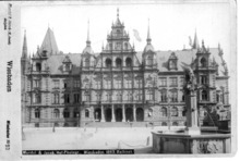
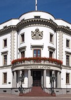
The Schloßplatz ("palace square") is situated in the center of the city, surrounded by several outstanding buildings. The ducal palace was begun under William, Duke of Nassau. Its foundations were laid in 1837 and it was completed in November 1841 (two years after William's death). For the twenty-six remaining years of ducal authority it was the residence of the ruling family. It later served as a secondary residence for the King of Prussia 1866 to 1918. It was later used as a headquarters for French and British occupying forces after World War I, then as a museum.
Since 1945, the building has served as Landtag (parliamentary building) for the state of Hesse. The site of the palace had been that of a castle, probably from the early Middle Ages, around which the city had developed. While nothing is known of the former castle, remains of it were uncovered during excavations after World War II.

The new town hall was built in 1887. A tile mosaic in front of the town hall shows the heraldic eagle of the Kingdom of Prussia (of which Wiesbaden was a part at the time), the coat of arms of the Prussian Province of Hesse-Nassau, and the fleur-de-lis of Wiesbaden. The old town hall, built in 1610, is the oldest preserved building in the city center and now is used as a civil registry office.
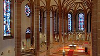
The Protestant Marktkirche ("market church") was built from 1852 to 1862 in a neo-Gothic style. Its western steeple is 92 metres (302 feet) in height, making the church the highest building in the city.
Kurhaus and Theater[edit]

The monumental Neo-Classical Kurhaus ("spa house") was built at the request of Kaiser Wilhelm II between 1904 and 1907. Its famous Spielbank (casino) is again in operation.
In front of the Kurhaus is a lawn known as the Bowling Green. To one side of the Bowling Green is the Kurhaus Kolonnade. Built in 1827, the 129 meter structure is the longest hall in Europe supported by pillars. To the other side is the Theater Kolonnade, built in 1839. It is adjacent to the Hessisches Staatstheater Wiesbaden, built between 1892 and 1894.
St. Bonifatius[edit]
St. Bonifatius, the first church for the Catholic community after the Reformation, was built from 1845 until 1849 by Philipp Hoffmann in Gothic Revival style and dedicated to Saint Boniface.
St. Elizabeth's Church[edit]
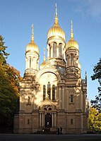
The Russian Orthodox Church of Saint Elizabeth, called Griechische Kapelle (Greek chapel) locally, was built on the Neroberg from 1847 to 1855 by Duke Adolf of Nassau on the occasion of the early death of his wife Elizabeth Mikhailovna, who died in childbirth. The architect was again Philipp Hoffmann.
Other sights[edit]
Another building from the regency of Duke Wilhelm is the Luisenplatz, a square named for the Duke's first wife. It is surrounded by Neoclassicist buildings, and in the middle of the square is the Waterloo Obelisk, commemorating the 683 Nassauers who died on 18 June 1815 near Hougoumont Farm in the respective battle against Napoleon.[18] Apart from the palace in the center, the ducal family had a large palace on the banks of the Rhine, known as Schloss Biebrich. This baroque building was erected in the first half of the 18th century.
North of the city is the Neroberg. From the top of this hill it is possible to view a panorama of the city. The Nerobergbahn funicular railway connects the city with the hill. South of it, the Nerotalanlagen are a park along a creek, created in 1897/98 as an English landscape garden.
One of the three Hessian state museums, Museum Wiesbaden is located in Wiesbaden.
Other churches are the Bergkirche, completed in 1879 in Gothic Revival style, and the Lutherkirche, finished in 1910 in Jugendstil. The church Mariä Heimsuchung is a tall concrete landmark in the Kohlheck suburb.
Oriental Christianity is also represented with the St. Isaiah Syriac Orthodox Church on the Willi-Juppe-Straße in Dotzheim, built 2016 by Suryoye-Assyrians.
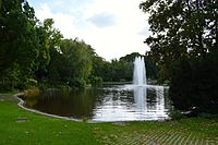
The Warmer Damm park is a 4.5-hectare park on the east side of Wilhelmstrasse and south of the State theater and Kurhaus which features a lake, a fountain, various statues, and large grassy areas. The park was created in 1859–1860 and is named after the medieval fortifications around a pond into which the warm waters of the town's 26 warm springs flowed.[19]
Gallery[edit]
-
 Biebrich Palace
 -
 City Palace
 -
 Nerobergbahn funicular
 -
 Griechische Kapelle
 -
 Nerotalanlagen
 -
 Marktkirche
 -
 Warmer Damm
 -
 Warmer Damm
 -
 St. Bonifatius


Boroughs of Wiesbaden[edit]
The city of Wiesbaden is divided into 26 boroughs: five in the central city and 21 suburban districts. The 21 suburban districts were incorporated in four phases from 1926 to 1977. The former Mainz suburbs on the right bank of river Rhine viz. Amöneburg, Kastel and Kostheim have belonged to Wiesbaden since 1945.
.svg)
Inner boroughs[edit]
| Borough | Area | Population | Density | Purchasing power per inhabitant |
Map |
|---|---|---|---|---|---|
| Mitte[20] | 1.53 km2 | 20,797 | 13,593 | 19,707 € | |
| Nordost[21] | 19.44 km2 | 22,621 | 1,163 | 21,709 € | |
| Rheingauviertel[22] | 2.47 km2 | 19,802 | 8,017 | 17,461 € | |
| Südost[23] | 6.62 km2 | 18,835 | 2,845 | 24,370 € | |
| Westend[24] | 0.67 km2 | 16,528 | 24,669 | 19,047 € |
Suburban boroughs[edit]
| Borough | Area | Population | Density | Purchasing power per inh. |
Incorporated since | Map |
|---|---|---|---|---|---|---|
| Auringen[25] | 3.12 km2 | 3,399 | 1,079 | 22,114 € | 1 January 1977 | |
| Biebrich[26] | 12.99 km2 | 36,896 | 2,840 | 18,779 € | 28 October 1926 | |
| Bierstadt[27] | 9.22 km2 | 12,109 | 1,313 | 22,807 € | 1 April 1928 | |
| Breckenheim[28] | 6.53 km2 | 3,375 | 517 | 22,074 € | 1 January 1977 | |
| Delkenheim[29] | 7.43 km2 | 4,938 | 665 | 20,908 € | 1 January 1977 | |
| Dotzheim[30] | 18.27 km2 | 26,234 | 1,436 | 18,793 € | 1 April 1928 | |
| Erbenheim[31] | 11.27 km2 | 9,258 | 821 | 19,357 € | 1 April 1928 | |
| Frauenstein[32] | 10.65 km2 | 2,359 | 222 | 19,365 € | 1 April 1928 | |
| Heßloch[33] | 1.54 km2 | 695 | 451 | 24,525 € | 1 April 1928 | |
| Igstadt[34] | 7.26 km2 | 2,090 | 288 | 21,869 € | 1 April 1928 | |
| Klarenthal[35] | 6.13 km2 | 10,280 | 1,677 | 18,103 € | 1 September 1964 | |
| Kloppenheim[36] | 5.39 km2 | 2,301 | 427 | 21,592 € | 1 April 1928 | |
| Mainz-Amöneburg[37] | 3.71 km2 | 1,444 | 389 | 17,267 € | 25 July 1945 | |
| Mainz-Kastel[38] | 9.51 km2 | 12,021 | 1,264 | 19,874 € | 25 July 1945 | |
| Mainz-Kostheim[39] | 9.53 km2 | 13,935 | 1,462 | 18,623 € | 25 July 1945 | |
| Medenbach[40] | 4.74 km2 | 2,501 | 560 | 21,170 € | 1 January 1977 | |
| Naurod[41] | 10.99 km2 | 4,414 | 402 | 21,865 € | 1 January 1977 | |
| Nordenstadt[42] | 7.73 km2 | 7,896 | 1,021 | 21,503 € | 1 January 1977 | |
| Rambach[43] | 9.92 km2 | 2,175 | 219 | 24,902 € | 1 April 1928 | |
| Schierstein[44] | 9.43 km2 | 10,129 | 1,074 | 19,938 € | 28 October 1926 | |
| Sonnenberg[45] | 8.34 km2 | 7,972 | 956 | 27,701 € | 28 October 1926 |
Population[edit]

| Year | Pop. | ±% |
|---|---|---|
| 1521 | 192 | — |
| 1699 | 730 | +280.2% |
| 1722 | 1,329 | +82.1% |
| 1800 | 2,239 | +68.5% |
| 1840 | 11,648 | +420.2% |
| 1861 | 20,800 | +78.6% |
| 1871 | 35,500 | +70.7% |
| 1880 | 50,238 | +41.5% |
| 1890 | 64,670 | +28.7% |
| 1900 | 86,111 | +33.2% |
| 1905 | 100,953 | +17.2% |
| 1910 | 109,002 | +8.0% |
| 1917 | 86,555 | −20.6% |
| 1925 | 102,737 | +18.7% |
| 1933 | 159,755 | +55.5% |
| 1939 | 170,354 | +6.6% |
| 1946 | 188,370 | +10.6% |
| 1950 | 220,741 | +17.2% |
| 1956 | 244,994 | +11.0% |
| 1961 | 253,280 | +3.4% |
| 1965 | 260,331 | +2.8% |
| 1970 | 250,122 | −3.9% |
| 1980 | 274,464 | +9.7% |
| 1987 | 251,871 | −8.2% |
| 1990 | 260,301 | +3.3% |
| 2000 | 270,109 | +3.8% |
| 2005 | 274,611 | +1.7% |
| 2010 | 275,976 | +0.5% |
| 2015 | 276,218 | +0.1% |
| 2019 | 278,764 | +0.9% |
| Population size may be affected by changes in administrative divisions. | ||
Wiesbaden has a population of about 280,000. In 1946, when Wiesbaden became the capital of Hesse state, it had a population of about 188,000. At that time, Wiesbaden was a part of American occupied zone and parts of the city of Mainz, which was the right side on the Rhine river, became a part of Wiesbaden. In 1950s many Americans came to Wiesbaden due to its jobs by military bases. Many people who work in Frankfurt live in Wiesbaden due to its high rent of the city. Wiesbaden is one of the most international cities in Germany with people from over 180 countries.

List of largest groups of foreign residents of Wiesbaden:[46]
| Rank | Nationality | Population (2022) |
|---|---|---|
| 1 | 9,351 | |
| 2 | 4,648 | |
| 3 | 4,089 | |
| 4 | 3,678 | |
| 5 | 3,265 | |
| 6 | 2,843 | |
| 7 | 2,774 | |
| 8 | 2,495 | |
| 9 | 1,947 | |
| 10 | 1,815 | |
| 11 | 1,801 | |
| 12 | 1,523 | |
| 13 | 1,333 | |
| 14 | 1,245 | |
| 15 | 1,240 | |
| 16 | 1,143 | |
| 17 | 1,138 | |
| 18 | 820 | |
| 19 | 774 | |
| 20 | 713 |
Politics[edit]
Mayor[edit]
.svg)
The current mayor of Wiesbaden is Gert-Uwe Mende of the Social Democratic Party (SPD), who was elected in 2019.
The most recent mayoral election was held on 26 May 2019, with a runoff held on 16 June, and the results were as follows:
| Candidate | Party | First round | Second round | |||
|---|---|---|---|---|---|---|
| Votes | % | Votes | % | |||
| Gert-Uwe Mende | Social Democratic Party | 29,940 | 27.1 | 41,000 | 62.0 | |
| Eberhard Seidensticker | Christian Democratic Union | 26,997 | 24.5 | 25,104 | 38.0 | |
| Christiane Hinninger | Alliance 90/The Greens | 25,849 | 23.4 | |||
| Sebastian Rutten | Free Democratic Party | 11,590 | 10.5 | |||
| Eckhard Müller | Alternative for Germany | 6,859 | 6.2 | |||
| Ingo von Seemen | The Left | 5,336 | 4.8 | |||
| Christian Bachmann | Free Voters | 3,812 | 3.5 | |||
| Valid votes | 110,383 | 98.9 | 66,104 | 98.6 | ||
| Invalid votes | 1,202 | 1.1 | 937 | 1.4 | ||
| Total | 111,585 | 100.0 | 67,041 | 100.0 | ||
| Electorate/voter turnout | 208,686 | 53.5 | 208,821 | 32.1 | ||
| Source: City of Wiesbaden (1st round, 2nd round) | ||||||
The following is a list of mayors since 1945:[a]
- 1849–1868: Heinrich Fischer
- 1868–1882: Wilhelm Lanz
- 1882–1883: Christian Schlichter
- 1883–1913: Carl Bernhard von Ibell
- 1913–1919: Karl Glässing
- 1919–1929: Fritz Travers
- 1930–1933: Georg Krücke
- 1933–1937: Alfred Schulte
- 1937–1945: Erich Mix
- 1945–1946: Georg Krücke
- 1946–1953: Hans Heinrich Redlhammer
- 1951–1954: Georg Kluge
- 1954–1960: Erich Mix
- 1960–1968: Georg Buch
- 1968–1980: Rudi Schmitt
- 1980–1982: Georg-Berndt Oschatz
- 1982–1985: Hans-Joachim Jentsch
- 1985–1997: Achim Exner
- 1997–2007: Hildebrand Diehl
- 2007–2013: Helmut Müller
- 2013–2019: Sven Gerich
- 2019– : Gert-Uwe Mende[48]
City council[edit]

The Wiesbaden city council (Stadtverordnetenversammlung) governs the city alongside the Mayor. The most recent city council election was held on 14 March 2021, and the results were as follows:
| Party | Lead candidate | Votes | % | +/- | Seats | +/- | |
|---|---|---|---|---|---|---|---|
| Christian Democratic Union (CDU) | Daniela Georgi | 1,526,381 | 23.5 | 19 | |||
| Alliance 90/The Greens (Grüne) | Christiane Hinninger | 1,390,605 | 21.4 | 17 | |||
| Social Democratic Party (SPD) | Hendrik Schmehl | 1,320,299 | 20.3 | 17 | |||
| Free Democratic Party (FDP) | Christian Diers | 675,021 | 10.4 | 8 | ±0 | ||
| Alternative for Germany (AfD) | Eckhard Müller | 423,519 | 6.5 | 5 | |||
| The Left (Die Linke) | Ingo von Seemen | 402,735 | 6.2 | 5 | ±0 | ||
| Volt Germany (Volt) | Daniel Weber | 246,454 | 3.8 | New | 3 | New | |
| Free Voters (FW) | Christian Bachmann | 163,942 | 2.5 | 2 | |||
| Initiative Pro Auto Wiesbaden (Pro Auto) | Christian Hill | 105,047 | 1.6 | New | 1 | New | |
| Citizens' List Wiesbaden (BLW) | Monika Becht | 73,255 | 1.1 | 1 | ±0 | ||
| Die PARTEI (PARTEI) | Lukas Haker | 51,343 | 0.8 | New | 1 | New | |
| Independent List Wiesbaden (ULW) | Veit Wilhelmy | 50,920 | 0.8 | 1 | ±0 | ||
| Alliance for Innovation and Justice (BIG) | Faissal Wardak | 44,344 | 0.7 | 1 | |||
| Liberal Conservative Reformers (LKR) | Thomas Preinl | 25,988 | 0.4 | New | 0 | New | |
| Valid votes | 83,885 | 95.9 | |||||
| Invalid votes | 3,597 | 4.1 | |||||
| Total | 87,482 | 100.0 | 81 | ±0 | |||
| Electorate/voter turnout | 209,347 | 41.8 | |||||
| Source: Statistics Hesse | |||||||
Transport[edit]

Roads[edit]
Wiesbaden is well connected to the German motorway (Autobahn) system. The Wiesbadener Kreuz is an Autobahn interchange east of the city where the Bundesautobahn 3 (A 3), Cologne to Würzburg, and the Bundesautobahn 66 (A 66), Rheingau to Fulda, meet. With approximately 210,000 cars daily it is one of the most heavily used interchange in Germany. The Bundesautobahn 66 (A 66) connects Wiesbaden with Frankfurt.
The Bundesautobahn 643 (A 643) is mainly a commuter motorway which starts in the south of the city centre, runs through the southern part of Wiesbaden crosses the Rhine via the Schierstein Bridge and connect in the northwestern part of Mainz to the A60. The Bundesautobahn 671 (A 671) is a very short motorway in the southeastern part of Wiesbaden which primarily serves as a fast connection between the city centre and the Bundesautobahn 60 to serve the cities like Rüsselsheim, Darmstadt and the Rhine-Neckar region (Mannheim, Ludwigshafen and Heidelberg).
The downtown area is bordered on the north side by Taunusstrasse, which has once featured many antique stores.[49] The east side is constrained by Wilhelmstrasse, created by Christian Zais. This 1,000 meter-long street is named after Duke William of Nassau (German Wilhelm), not Emperor Wilhelm II, as many mistakenly believe.[50]
The streets of central Wiesbaden are regularly congested with cars during rush hour. Besides some areas, especially the Ringroad and not directly in the centre, and the southern arterial roads like the Mainzer Straße, Biebricher Allee and Schiersteiner Straße.
Rail[edit]

Wiesbaden's main railway station and several minor railway stops connect the town with Frankfurt, Darmstadt, Mainz, Limburg, and Koblenz via Rüdesheim. Wiesbaden Hauptbahnhof is connected to the Cologne-Frankfurt high-speed rail line by a 13-kilometer branch line. Hamburg, München, Leipzig, Dresden, Stuttgart, Mannheim, and Hanover are connected directly to Wiesbaden via long-distance service of the Deutsche Bahn. More services to locations outside the immediate area connect through Mainz or Frankfurt Airport or Frankfurt Hauptbahnhof. Regional trains and bus services are coordinated by the Rhein-Main-Verkehrsverbund.
Public transport[edit]

- S-Bahn
Wiesbaden is connected to the Frankfurt S-Bahn network and served by three lines (![]()
![]()
![]() ) which connect Wiesbaden with the densely populated Rhine Main Region. All routes have an at least 30 minute service during the day, in the rush hour partially every 15 minutes schedule. It provides access to nearby cities such as Mainz, Rüsselsheim, Frankfurt, Hanau, and Offenbach am Main, and smaller towns that are on the way.
) which connect Wiesbaden with the densely populated Rhine Main Region. All routes have an at least 30 minute service during the day, in the rush hour partially every 15 minutes schedule. It provides access to nearby cities such as Mainz, Rüsselsheim, Frankfurt, Hanau, and Offenbach am Main, and smaller towns that are on the way.
- Bus
The city's public transportation service ESWE Verkehr connects all city districts to downtown by 45 bus lines in the daytime and 9 bus lines in the night. Five more bus lines, operated by the public transportation service of the city of Mainz, connects Wiesbaden's districts Kastel and Kostheim to Mainz downtown.
Airports[edit]

The city can be accessed from around the world via Frankfurt Airport (Flughafen Frankfurt am Main) which is located 15 km (9.3 mi) east of Wiesbaden. The airport has four runways and serves 265 non-stop destinations. Run by transport company Fraport it ranks among the world's 10 busiest airports by passenger traffic and is the second busiest airport by cargo traffic in Europe. The airport also serves as a hub for Condor and as the main hub for German flag carrier Lufthansa. Depending on whether total passengers or flights are used, it ranks second or third busiest in Europe alongside London Heathrow Airport and Paris Charles de Gaulle Airport. Passenger traffic at Frankfurt Airport in 2011 was 56.5 million.
The airport can be reached by car or train and has two railway stations, one for regional and one for long-distance traffic. The S-Bahn lines S8 and S9 (direction Offenbach Ost or Hanau Hbf) departing at the regional train station take 30 minutes from the airport to Wiesbaden Central Station, the ICE trains departing at the long-distance railway station take also 30 minutes to the central station.
Despite the name, Frankfurt Hahn Airport (Flughafen Frankfurt-Hahn) is not located anywhere near Frankfurt but is instead situated approximately 100 km (62 mi) from the city in Lautzenhausen (Rhineland-Palatinate). Hahn Airport was a major base for low-cost carrier Ryanair. This airport can be reached by car or bus. The nearest train station is in Traben-Trarbach, it is ca. 17 km (11 mi) from the airport, on foot. The roads are not lit.
Port[edit]
There are small container port operations nearby on the rivers Rhine and Main.
Military[edit]
Lucius D. Clay Kaserne (formerly Wiesbaden Army Airfield or WAAF) is located adjacent to Wiesbaden-Erbenheim and is home to the US Army in Europe (USAREUR) headquarters, the 2nd Signal Brigade and the 66th Military Intelligence Brigade. The airfield was one of the points of origin for flights to Berlin in support of Operation Vittles (the Berlin airlift) during the Soviet blockade of Berlin. General Clay, the commander of the US occupation zone in Germany, was the architect of the airlift.
The United States Army runs a garrison in Wiesbaden. The facilities for US soldiers and families are spread across various locations including: Aukamn, Hainerberg, Mainz-Kastel and the Wiesbaden Army-Airfield, where the names of the streets are named after servicemen and women who sacrificed their lives during the Berlin Airlift.[51]
Economy[edit]
Wiesbaden hosts a number of international companies, which have their German or European headquarters there including Abbott Laboratories, DXC Technology, Ferrari, Federal-Mogul, Melbourne IT, Porsche, Norwegian Cruise Line, and SCA. Several German companies also have their headquarters in Wiesbaden, including SGL Carbon, Dyckerhoff, KION Group, DBV-Winterthur, and R + V Versicherung. Wiesbaden is also home to the "Industriepark Kalle-Albert", an industrial park in the southern quarter of Biebrich. It is one of the largest in Germany with over 80 companies from the pharmaceutical and chemical industries, including Agfa-Gevaert, Clariant, Mitsubishi Chemical Corporation, and Shin-Etsu Chemical. The park was founded by chemical company Hoechst AG in 1997.
The Federal Criminal Police Office and the Federal Statistical Office of Germany are both based in Wiesbaden, along with many Hessian ministries such as the Hessian State Criminal Police Office.
At approximately €77,500, Wiesbaden has the second largest gross domestic product per inhabitant in Hesse, after Frankfurt, making it one of the richest cities in Germany. The purchasing power per inhabitant is €22,500.[citation needed]
Culture[edit]
Wiesbaden's most important stage is the Hessisches Staatstheater Wiesbaden. Concert halls include the Friedrich-von-Thiersch-Saal of the Kurhaus. Wiesbaden has a State Library and a conservatory, where Max Reger studied and taught as a young man. Choirs such as the Wiesbadener Knabenchor, Schiersteiner Kantorei and Chor von St. Bonifatius are known in the region and even internationally.
International May Festival[edit]
The International May Festival is an annual arts festival presented by the Hessisches Staatstheater Wiesbaden every May. Established in 1896, it is one of the most distinguished international theatre and music festivals in the world. The festival features performances of plays, musicals, operas, and ballets. Concerts from a wide array of music are featured, as are artistic circus acts and modern dance presentations. Lectures, recitals, cabaret performances, and readings are also featured.[52]
Rheingau Wine Festival[edit]
The wines and sparkling wines of the close Rheingau are presented annually at the ten-day festival in August, Rheingauer Weinwoche (Rheingau Wine Week) around the Wiesbaden City Hall, on the Schlossplatz (Palace Square), the square Dern'sches Gelände and in the pedestrian area. At 118 booths, Rheingau and Wiesbaden vintners offer their wine and sparkling wine and invite to discover the already well known and favored, but also new vintages. Every year thousands of visitors use this opportunity to get acquainted with Rheingau Riesling wines and all their various facets and flavors. Regional specialities compatible with the wines are offered as well. A diversified musical program entertains the wine festival guests. Initiated more than 30 years ago by the Rheingau vintners, this wine festival has a long tradition.
Shooting Star Market[edit]
Wiesbaden's Sternschnuppenmarkt is located at the central Schlossplatz and the neighbouring streets of the parliamentary building, old town hall, and market church. The Sternschnuppenmarkt takes place from the end of November until 23 December every year and is open from Monday until Thursday 10:30 – 9:00 pm, Friday and Saturday 10:30 – 9:30 pm, and Sunday 12:00 – 9:00 pm.
The market is related to the city arms of Wiesbaden: the colours blue and gold and the three lilies are characteristic. Four gates and an illuminated floral roof symbolizing Fleur-de-lis, consisting of twelve over ten metre high and twelve metre wide luminous lilies, emboss the Sternschnuppenmarkt.
Over 110 booths are decorated in oriental style, coloured blue and gold, offering Christmas style goods, arts and crafts as well as nostalgic carousels and a toy train. A Christmas tree more than 28 metres (92 feet) tall is decorated with 1000 blue and golden ties, 2500 electric bulbs and 30 flash bulbs. The nativity scene displays life-sized wooden figures.
Rheingau Musik Festival[edit]

From the beginning in 1988 the Rheingau Musik Festival has staged summer concerts in the Marktkirche and in the concert hall of the Kurhaus now named Friedrich-von-Thiersch-Saal.
Sport[edit]
Since 2007 Wiesbaden has been home to SV Wehen Wiesbaden, an association football team that formerly played in nearby Taunusstein. The club was promoted to the 2. Bundesliga in 2019, but relegated back to the 3. Liga in 2020.
Twin towns – sister cities[edit]
Town twinning between Wiesbaden and other cities began with Klagenfurt in 1930, one of the first town-twinnings in Germany. Wiesbaden is twinned with:[53]
 Klagenfurt, Austria (1930)
 Montreux, Switzerland (1953)
 Friedrichshain-Kreuzberg (Berlin), Germany (1964)
 Ghent, Belgium (1969)
 Fondettes, France (1975)
 Ljubljana, Slovenia (1977)
 Kfar Saba, Israel (1981)
 San Sebastián, Spain (1981)
 Wrocław, Poland (1987)
 Royal Tunbridge Wells, England, United Kingdom (1989)
- Görlitz, Germany (1990)
 Ocotal, Nicaragua (1990)
 Fatih, Turkey (2012)
 Kamianets-Podilskyi, Ukraine (2023)
Coat of arms[edit]
Wiesbaden's coat of arms features three fleurs-de-lys, stylized representations of the city's heraldic symbol, the lily. The blazon is: "Azure, two and one fleurs-de-lys Or".
Notable people[edit]
- Kathrin Ackermann (born 1938), actress
- Adolphe, Grand Duke of Luxembourg (born 1817, Biebrich Palace), reign 23 November 1890 – 17 November 1905
- Norbert J. Becker (1937–2012), agricultural scientist and specialist in the area of vine breeding and viticulture
- Adolphus Busch (1839–1913), founder of Anheuser-Busch
- Sarah Colonna (born 1974), American stand-up comedian
- Shlomo Eckstein (1929–2020), Israeli economist and President of Bar-Ilan University
- Gisela Ehrensperger (born 1943), Swiss operatic soprano
- Petra Fuhrmann (1955–2019), member of the Hessian Landtag
- Biruté Galdikas (born 1946), Lithuanian-Canadian primatologist
- Jürgen Grabowski (1944–2022), footballer
- Peter Hanenberger (born 1942), automotive specialist for General Motors, previously chairman of Holden
- Franz Kaiser (1891–1962), astronomer, discoverer of asteroid 717 Wisibada and asteroid 765 Mattiaca, both named in honour of the city of Wiesbaden
- Wilhelm Kempf (1906–1982), Catholic theologian, Bishop of Limburg 1949–1981
- Michael Kessler (born 1967), actor and comedian
- Alfred Koerppen (1926–2022), organist, music pedagogue, composer and academic teacher
- Otto Krebs (1873–1941), industrialist and art collector
- Günther Lütjens (1889–1941), admiral and commander of the World War II naval Operation Rheinübung, aboard the battleship Bismarck
- Bruce Maxwell (born 1990), American baseball player (born on a U.S. military base)
- John McEnroe (born 1959), American tennis player (born on a U.S. military base)
- August Momberger (1905–1969), racing driver and engineer
- Melody Perkins (born 1974), American actress
- Emil Pfeiffer (1846–1921), physician
- Bud Pierce (born 1956), American politician
- Dieter Rams (born 1932), industrial designer, former head of design for Braun
- Rudolf von Ribbentrop (1921–2019), captain in the Waffen-SS, recipient of the Knights Cross of the Iron Cross for bravery
- Nico Rosberg (born 1985), Finnish-German racing driver, 2016 Formula One World Champion
- Volker Schlöndorff (born 1939), film director
- Kristina Schröder (born 1977), politician (CDU)
- Henry Schwarzschild (1925–1996), American activist for civil rights and human rights
- Kiki VanDeWeghe (born 1958), American basketball player, coach and executive
- Valerie Weigmann (born 1989), Filipino-German actress, host and Miss World Philippines 2014 titleholder
- Silvia Weiss, soprano
- William IV, Grand Duke of Luxembourg (born 1852, Biebrich Palace), reign 17 November 1905 – 25 February 1912
- Maria Yakunchikova (1870–1902), Russian painter and graphic artist
- Schoolboy Q (born 1986), American rapper (born on a U.S. military base)
- Leona Riemann (born 1952) German writer, author, and publisher
Notable residents[edit]
- Peter Carl Fabergé, fled Russia to Germany, settled first in Bad Homburg and then in Wiesbaden
- Alexej von Jawlensky, Russian Expressionist painter, lived there in 1922–1941 and died there
- Hava Lazarus-Yafeh (1930–1998), Orientalist, scholar, editor, and educator; born in Wiesbaden.[54]
- Béla Kéler, Hungarian composer, he lived in Wiesbaden from 1863 until his death in 1882. He led the orchestra of the Second Regiment of the Duke of Nassau (1863-1866), and later also the spa orchestra (1870-1872).
- Vladimir Nabokov, Russian novelist, poet, translator and entomologist, writes in his autobiography about his memories of his childhood in Wiesbaden
- Priscilla Presley, lived in Wiesbaden with her parents. It was here that she met Elvis Presley.
- Max Reger, studied in Wiesbaden
- Mickey Rourke, resides in Wiesbaden at least part-time with his Russian-born girlfriend Anastassija Makarenko
- Debby Ryan, American actress, lived in Wiesbaden for three years
- Richard Wagner, settled in Biebrich (now part of Wiesbaden) in 1861, after the political ban against him in Germany was lifted. It was there that he began work on Die Meistersinger von Nürnberg.
- Reese Witherspoon, lived in Wiesbaden with her parents
- Mayte Garcia, American belly dancer, actress, author, singer and choreographer, lived in Wiesbaden with her parents. It was here that she met her future husband, the singer Prince, backstage at one of his concert
- Eno, rapper, lives in Wiesbaden
Notable visitors[edit]
- In the 19th century, visitors to the Wiesbaden's famous hot springs included Johann Wolfgang von Goethe and Johannes Brahms. Brahms' Symphony No. 3 (Op. 90) was composed in Wiesbaden in the summer of 1883.
- Washington Roebling, chief engineer of the Brooklyn Bridge, came to Wiesbaden—along with his wife, Emily Warren Roebling—in 1873, hoping that the warm springs would ameliorate the effects of the decompression sickness he suffered as a result of working in caissons of the bridge.[55]
- Russian author Fyodor Dostoevsky, who suffered from an acute gambling compulsion, allegedly lost his travelling money in Wiesbaden's Spielbank casino in 1865. The experience became the inspiration of his 1866 novel The Gambler (Russian Игрок), set in the fictitious place "Roulettenburg". Some historians have disputed this account, saying that Bad Homburg was the location for Dostoevsky's real-life misfortune.
- Wiesbaden's Bowling Green has been very popular in recent years since various open-air concerts have been held there by artists like Elton John (2009, 2011 & 2019), Rod Stewart (2009), Eric Clapton (2008), R.E.M. (2003), Sting (2001), Bryan Adams (2000), Simply Red (1999), José Carreras (1992), and Luciano Pavarotti (1993). Lionel Richie and Plácido Domingo (2nd time in Wiesbaden) have also performed there.
Rivalry with Mainz[edit]
Mainz, on the opposite side of the Rhine, is Wiesbaden's archrival – the two cities are the capitals of their respective Bundesländer, and citizens of both cities jokingly refer to those on the other one as "living on the wrong side of the river".
Fictional references[edit]
- In his short story "The Horror of the Heights" (1913), Sir Arthur Conan Doyle refers to an aerial region over Wiesbaden and Homburg in which aircraft mysteriously vanish.
- In the 1983 American television movie The Day After, Wiesbaden was the first city to be destroyed by a nuclear weapon during the escalating war between NATO and Warsaw Pact forces that eventually leads to a full-scale nuclear exchange between the United States and the Soviet Union.
- The historical novel series Romanike (2006–2014) by Codex Regius features Wiesbaden in the Roman age, or Aquae Mattiacorum, as one of its main locations.[56]
References[edit]
- ^ "Ergebnisse der letzten Direktwahl aller hessischen Landkreise und Gemeinden" (XLS) (in German). Hessisches Statistisches Landesamt. 5 September 2022. Archived from the original on 13 November 2022. Retrieved 11 November 2022.
- ^ "Bevölkerung in Hessen am 31.12.2022 nach Gemeinden" (XLS) (in German). Hessisches Statistisches Landesamt. June 2023.
- ^ Wiesbadener Tagblatt. 18 September 2008
- ^ Heinrich-Verlag GmBH (2011). Wiesbaden: For Old Friends and New. Heinrich-Verlag GmBH. p. 4. ISBN 978-3-89889-167-7.
- ^ "Kaufkraft 2017" (PDF). IHK Wiesbaden. Archived from the original (PDF) on 25 August 2017. Retrieved 24 August 2017.
- ^ "Weather Information for Wiesbaden". Archived from the original on 26 April 2012. Retrieved 8 April 2012.
- ^ The hypothesis of the Heidenmauer being a remainder of an aquaeduct now has been definitely proven wrong. Further reading see: Klee, Margot: Sperrmauer oder Aquädukt? Zur Deutung der Heidenmauer in Wiesbaden. (Blocking wall or aquaeduct. Re. Interpretation of the Heidenmauer in Wiesbaden). In: NA (Nassauische Annalen) 2014. Eck Werner: Ein praefectus Aquen(sium), kein praefectus aqu(a)e. Zur Inschrift CIL XIII 7279 aus Mainz Kastel (A praefectus Aquen(sium), not a praefectus aqu(a)e. Re. Inscription CIL XIII 7279 from Mainz Kastel). In: NA (Nassauische Annalen) 2014.
- ^ Csysz, Walter: Wiesbaden in der Römerzeit. Aalen: Theiss editors, 2000; mentioned by Roman poet Martial: Epigrammata 14, 27.
- ^ Heinrich-Verlag GmBH (2011). Wiesbaden: For Old Friends and New. Heinrich-Verlag GmBH. p. 11. ISBN 978-3-89889-167-7.
- ^ Heinrich-Verlag GmBH (2011). Wiesbaden: For Old Friends and New. Heinrich-Verlag GmBH. p. 12. ISBN 978-3-89889-167-7.
- ^ "Wiesbaden | The Valley of the Communities". www.yadvashem.org. Archived from the original on 30 January 2023. Retrieved 8 January 2023.
- ^ Tessin, Georg (1996). Zweng, Christian (ed.). Verzeichnis der Friedensgarnisonen 1932–1939 und Stationierungen im Kriege 1939–1945. Wehrkreise VII–XIII. Verbände und Truppen der deutschen Wehrmacht und Waffen-SS im Zweiten Weltkrieg 1939-1945 (in German). Vol. 17. Osnabrück: Biblio Verlag. p. 276. ISBN 3764809418.
- ^ a b Heinrich-Verlag GmBH (2011). Wiesbaden: For Old Friends and New. Heinrich-Verlag GmBH. p. 80. ISBN 978-3-89889-167-7.
- ^ "Lager für Sinti und Roma Wiesbaden". Bundesarchiv.de (in German). Retrieved 9 January 2024.
- ^ Megargee, Geoffrey P. (2009). The United States Holocaust Memorial Museum Encyclopedia of Camps and Ghettos 1933–1945. Volume I. Indiana University Press, United States Holocaust Memorial Museum. p. 842. ISBN 978-0-253-35328-3.
- ^ The Last Offensive by Charles B. MacDonald, Library of Congress Catalog Card Number 71-183070
- ^ "Wiesbaden ceremonies mark key milestones in U.S. Army Europe transition". Eur.army.mil. 14 June 2012. Archived from the original on 17 March 2013. Retrieved 13 August 2023.
- ^ The Duchy of Nassau participated with two regiments of total 6180 men infantry, about half came under fire and mainly 2nd rgt. 1st battalion in the defense of the fortified Hougoumont Farm. The duke issued a medal to all surviving participants in 1816. https://www.nmm.nl/zoeken-in-de-collectie/detail/231159/[permanent dead link]
- ^ Heinrich-Verlag GmBH (2011). Wiesbaden: For Old Friends and New. Heinrich-Verlag GmBH. pp. 14–15. ISBN 978-3-89889-167-7.
- ^ Landeshauptstadt Wiesbaden – Ortsbezirk Mitte Archived 14 August 2011 at the Wayback Machine, September 2009
- ^ Landeshauptstadt Wiesbaden – Ortsbezirk Nordost Archived 16 August 2012 at the Wayback Machine, September 2009
- ^ Landeshauptstadt Wiesbaden – Ortsbezirk Rheingauviertel Archived 14 August 2011 at the Wayback Machine, September 2009
- ^ Landeshauptstadt Wiesbaden – Ortsbezirk Südost Archived 19 June 2012 at the Wayback Machine, September 2009
- ^ Landeshauptstadt Wiesbaden – Ortsbezirk Westend[permanent dead link], September 2009
- ^ Landeshauptstadt Wiesbaden – Ortsbezirk Auringen Archived 14 August 2011 at the Wayback Machine, September 2009
- ^ Landeshauptstadt Wiesbaden – Ortsbezirk Biebrich Archived 16 August 2012 at the Wayback Machine, September 2009
- ^ Landeshauptstadt Wiesbaden – Ortsbezirk Bierstadt Archived 19 June 2012 at the Wayback Machine, September 2009
- ^ Landeshauptstadt Wiesbaden – Ortsbezirk Breckenheim Archived 5 June 2012 at the Wayback Machine, September 2009
- ^ Landeshauptstadt Wiesbaden – Ortsbezirk Delkenheim Archived 14 August 2011 at the Wayback Machine, September 2009
- ^ Landeshauptstadt Wiesbaden – Ortsbezirk Dotzheim Archived 13 August 2011 at the Wayback Machine, September 2009
- ^ Landeshauptstadt Wiesbaden – Ortsbezirk Erbenheim Archived 14 August 2011 at the Wayback Machine, September 2009
- ^ Landeshauptstadt Wiesbaden – Ortsbezirk Frauenstein Archived 15 August 2012 at the Wayback Machine, September 2009
- ^ Landeshauptstadt Wiesbaden – Ortsbezirk Heßloch Archived 14 August 2011 at the Wayback Machine, September 2009
- ^ Landeshauptstadt Wiesbaden – Ortsbezirk Igstadt Archived 16 August 2012 at the Wayback Machine, September 2009
- ^ Landeshauptstadt Wiesbaden – Ortsbezirk Klarenthal Archived 13 August 2011 at the Wayback Machine, September 2009
- ^ Landeshauptstadt Wiesbaden – Ortsbezirk Kloppenheim Archived 15 August 2012 at the Wayback Machine, September 2009
- ^ Landeshauptstadt Wiesbaden – Ortsbezirk Mainz-Amöneburg Archived 14 August 2011 at the Wayback Machine, September 2009
- ^ Landeshauptstadt Wiesbaden – Ortsbezirk Mainz-Kastel Archived 18 August 2012 at the Wayback Machine, September 2009
- ^ Landeshauptstadt Wiesbaden – Ortsbezirk Mainz-Kostheim Archived 18 August 2012 at the Wayback Machine, September 2009
- ^ Landeshauptstadt Wiesbaden – Ortsbezirk Medenbach Archived 13 June 2010 at the Wayback Machine, September 2009
- ^ Landeshauptstadt Wiesbaden – Ortsbezirk Naurod Archived 14 August 2011 at the Wayback Machine, September 2009
- ^ Landeshauptstadt Wiesbaden – Ortsbezirk Nordenstadt Archived 11 November 2011 at the Wayback Machine, September 2009
- ^ Landeshauptstadt Wiesbaden – Ortsbezirk Rambach Archived 14 August 2011 at the Wayback Machine, September 2009
- ^ Landeshauptstadt Wiesbaden – Ortsbezirk Schierstein Archived 17 August 2012 at the Wayback Machine, September 2009
- ^ Landeshauptstadt Wiesbaden – Ortsbezirk Sonnenberg Archived 16 August 2012 at the Wayback Machine, September 2009
- ^ "Landeshauptstadt Wiesbaden: Statistisches Jahrbuch 2016 – Bevölkerung" (PDF). wiesbaden.de. 26 March 2017. Archived from the original (PDF) on 25 June 2018. Retrieved 27 April 2017.
- ^ "Amtsvorgänger". Archived from the original on 25 December 2009. Retrieved 13 December 2009.
- ^ "Porträt Gert-Uwe Mende | Landeshauptstadt Wiesbaden". Archived from the original on 27 August 2019. Retrieved 27 August 2019.
- ^ Heinrich-Verlag GmBH (2011). Wiesbaden: For Old Friends and New. Heinrich-Verlag GmBH. p. 10. ISBN 978-3-89889-167-7.
- ^ It features a wide variety of businesses from restaurants to hotels to banks.Heinrich-Verlag GmBH (2011). Wiesbaden: For Old Friends and New. Heinrich-Verlag GmBH. p. 11. ISBN 978-3-89889-167-7.
- ^ Fish, Todd J. "About". U.S. Army Garrison Wiesbaden. Accessed 11 September 2016. http://www.wiesbaden.army.mil/about/ Archived 19 September 2016 at the Wayback Machine.
- ^ "International May Festival". staatstheater-wiesbaden.de. Archived from the original on 19 July 2011. Retrieved 5 September 2010.
- ^ "Partnerstädte". wiesbaden.de (in German). Wiesbaden. Archived from the original on 27 July 2022. Retrieved 17 February 2021.
- ^ Strauss, Herbert A.; Röder, Werner; Caplan, Hannah; Radvany, Egon; Möller, Horst; Schneider, Dieter Marc (7 February 2014). "Lazarus-Yafeh, Hava". The Arts, Sciences, and Literature. Walter de Gruyter GmbH & Co KG. p. 699. ISBN 978-3-11-097027-2. Archived from the original on 18 September 2023. Retrieved 2 June 2022.
- ^ Wagner, Erica, Chief Engineer: Washington Roebling, The Man Who Built the Brooklyn Bridge, New York, Bloomsbury, 2017, p.191ff
- ^ Codex Regius. "Romanike (by Codex Regius)". Archived from the original on 6 August 2016. Retrieved 8 November 2014.
Notes[edit]
External links[edit]
- Official website
- The Jewish Community of Wiesbaden on the Yad Vashem website
- Wiesbaden City Panoramas – Panoramic Views and virtual Tours
- Photos of Wiesbaden
- More Photos of Wiesbaden Archived 22 July 2012 at the Wayback Machine
- Wiesbaden Daily Photos
- Webcam to Wiesbaden (Remote-Control Pan-Tilt)
- 23 live webcams to Wiesbaden
- Webcam to Railway-Station Wiesbaden
- Wiesbaden U.S. Army Garrison
- Chisholm, Hugh, ed. (1911). . Encyclopædia Britannica (11th ed.). Cambridge University Press.
Places adjacent to Wiesbaden | |
|---|---|
| |||||||
| |||||||
| |||||||
| International | |
|---|---|
| National | |
| Geographic | |
| Other | |