Cachoeira dos Índios
Belém do Cachoeira dos Índios | |
|---|---|
Municipality | |
| The Municipality of Cachoeira dos Índios | |
 | |
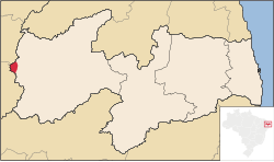
 Location of Cachoeira dos Índios in the State of Paraíba | |
| Coordinates: 06°55′37″S 38°40′26″W / 6.92694°S 38.67389°W | |
| Country | |
| Region | Northeast |
| State | |
| Government | |
| • Mayor | Francisco Dantas Ricarte (DEM) |
| Area | |
| • Total | 172.906 km2 (66.759 sq mi) |
| Population (2020 [1]) | |
| • Total | 10,305 |
| • Density | 47.5/km2 (123/sq mi) |
| Time zone | UTC−3 (BRT) |
| HDI (2000) | 0.577 – medium[2] |
Cachoeira dos Índios is the westernmost municipality in the Brazilian state of Paraíba. As of 2020, it had a population of 10,305.
References[edit]
- ^ IBGE 2020
- ^ "Archived copy". Archived from the original on 2009-10-03. Retrieved 2009-12-17.
{{cite web}}: CS1 maint: archived copy as title (link) - UNDP
