
Saddle Mountain (Alberta)
| Saddle Mountain | |
|---|---|
 East aspect | |
| Highest point | |
| Elevation | 2,433 m (7,982 ft)[1][2] |
| Prominence | 107 m (351 ft)[3] |
| Parent peak | Fairview Mountain (2,744 m) |
| Isolation | 0.74 km (0.46 mi)[3] |
| Listing | Mountains of Alberta |
| Coordinates | 51°23′35″N 116°12′31″W / 51.39306°N 116.20861°W[4] |
| Geography | |
 Saddle Mountain Location in Alberta  Saddle Mountain Saddle Mountain (Canada) | |
| Country | Canada |
| Province | Alberta |
| Protected area | Banff National Park |
| Parent range | Bow Range Canadian Rockies |
| Topo map | NTS 82N8 Lake Louise[4] |
| Geology | |
| Age of rock | Cambrian |
| Type of rock | Gog quartzite[1] |
| Climbing | |
| Easiest route | Trail + scrambling[5] |
Saddle Mountain is a 2,433-metre (7,982 ft) summit in Alberta, Canada.
Description[edit]
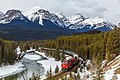
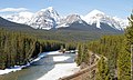
Saddle Mountain is located in the Bow Valley within Banff National Park, and it is part of the Bow Range of the Canadian Rockies. Lake Louise townsite is situated 4 kilometres (2.5 mi) to the northeast and the Continental Divide is 6 kilometres (3.7 mi) to the west. The nearest higher neighbor is Fairview Mountain, 1.2 km (0.75 mi) to the northwest.[3] Precipitation runoff from Saddle Mountain drains into tributaries of the Bow River. Topographic relief is modest as the summit rises over 600 meters (1,968 ft) above Paradise Creek in one kilometer (0.6 mile) and nearly 900 meters (2,953 ft) above Bow River in 3 km (1.9 mi). The peak is visible from Alberta Highway 1 to the east,[2] and is prominent in the iconic photographs taken from Morant's Curve.
Access[edit]
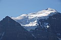
The Paradise Valley Trail leads from Lake Louise to Saddleback Pass, and from the pass an off-trail scramble leads to the top of Saddle Mountain. The summit offers one of the finest views of the area,[6] including the Bow Valley and a close view of the impressive north face of Mount Temple.
History[edit]
The mountain's descriptive name was applied in 1894 by Samuel E.S. Allen.[2][7] The mountain's toponym was officially adopted on April 3, 1952, by the Geographical Names Board of Canada.[4]
Geology[edit]
Like other mountains in Banff Park, Saddle Mountain is composed of sedimentary rock laid down during the Precambrian to Jurassic periods.[8] Formed in shallow seas, this sedimentary rock was pushed east and over the top of younger rock during the Laramide orogeny.[9]
Climate[edit]
Based on the Köppen climate classification, Saddle Mountain is located in a subarctic climate zone with cold, snowy winters, and mild summers.[10] Winter temperatures can drop below -20 °C with wind chill factors below -30 °C.
See also[edit]
Gallery[edit]
-
 Saddle Mountain seen from the southeast side of Fairview Mountain.
Saddleback Pass in lower right. -
 Mt. Temple (left), Saddle Mountain (centre), Fairview Mountain (right).
 -
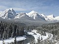
 Saddle Mountain (centre) seen from Morant's Curve
 -
 Mount Temple from the summit of Saddle Mountain
 -
 Winter scene from Morant's Curve.
Saddle Mountain left of center. -
 Saddle Mountain (upper left) from Morant's Curve
 -
 Mount Temple from Saddle Mountain
 -
 Haddo (left), Saddle Mountain (centre), Fairview Mountain (right), from Morant's Curve


.jpg)
References[edit]
- ^ a b Ben Gadd (2008), Canadian Rockies Geology Road Tours, Corax Press, ISBN 978-0-9692631-2-8, p. 137.
- ^ a b c "Saddle Mountain". cdnrockiesdatabases.ca. Retrieved 2023-03-02.
- ^ a b c "Saddle Mountain, Alberta". Peakbagger.com. Retrieved 2023-03-02.
- ^ a b c "Saddle Mountain". Geographical Names Data Base. Natural Resources Canada. Retrieved 2023-03-02.
- ^ Brian Patton, Bart Robinson (2007), Canadian Rockies Trail Guide, Summerthought Publishing, ISBN 978-0-9782375-0-9, p. 95.
- ^ Lawrence Johnstone Burpee (1914), Among the Canadian Alps, John Lane Company, p. 89.
- ^ Karamitsanis, Aphrodite (1991). Place Names of Alberta. Vol. I: Mountains, mountain parks, and foothills. University of Calgary Press. p. 215. ISBN 978-0-919813-73-1.
- ^ Belyea, Helen R. (1960). The Story of the Mountains in Banff National Park (PDF). parkscanadahistory.com (Report). Ottawa: Geological Survey of Canada. Archived (PDF) from the original on 2015-10-02. Retrieved 2019-09-13.
- ^ Gadd, Ben (2008). Geology of the Rocky Mountains and Columbias.
- ^ Peel, M. C.; Finlayson, B. L. & McMahon, T. A. (2007). "Updated world map of the Köppen−Geiger climate classification". Hydrol. Earth Syst. Sci. 11: 1633–1644. ISSN 1027-5606.
External links[edit]
- Parks Canada web site: Banff National Park
- Samuel E.S. Allen in memoriam: Americanalpineclub.org
Places adjacent to Saddle Mountain (Alberta) | ||||||||||||||||
|---|---|---|---|---|---|---|---|---|---|---|---|---|---|---|---|---|
| ||||||||||||||||